TopoQuest Logo
Do you find TopoQuest useful?
Help keep TopoQuest running and adding new maps/features by donating!
Bitcoin:  19c7KJd3qBynnjoSw5npx9KScwjBe4ifkT
Litecoin:  LXs6TkuXGGXo1vDsWCkWVdjQX94eUKd6ui
Home View Maps Find Maps Find Places Resources & Links


Conrad, Montana Topographic Map

USGS Map Title: Conrad, MT
USGS Map MRC: 48111B8
DRG (GeoTIFF) Download: o48111b8.tif


Neighboring USGS Topographic Map Quads:


  Belgian Hill, MT  
48112C1
 

  Pioneer School, MT  
48111C8
 

  Ledger, MT  
48111C7
 

  Sam George Hill, MT  
48112B1
 

  Conrad, MT  
48111B8
 

  Letz Lake, MT  
48111B7
 

  Gallup City, MT  
48112A1
 

  Conrad SW, MT  
48111A8
 

  Brady, MT  
48111A7


Map MRC Location:

N49°
W112°
N49°
W111°
H8 H7 H6 H5 H4 H3 H2 H1
G8 G7 G6 G5 G4 G3 G2 G1
F8 F7 F6 F5 F4 F3 F2 F1
E8 E7 E6 E5 E4 E3 E2 E1
D8 D7 D6 D5 D4 D3 D2 D1
C8 C7 C6 C5 C4 C3 C2 C1
B8 B7 B6 B5 B4 B3 B2 B1
A8 A7 A6 A5 A4 A3 A2 A1
N48°
W112°
N48°
W111°

Conrad, MT USGS 1:24K Topographic Map Preview:
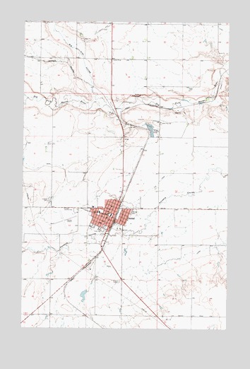
Conrad, MT USGS Topographic Map
Click on map above to begin viewing in our Map Viewer.

This topographic map contains these locations and features:
Feature Name Type Latitude Longitude GNIS ID View Map
Abel ParkParkN48.1761°W111.9564°1748748View Map
Abundant Life Christian CenterChurchN48.1750°W111.9464°1748730View Map
Anniston (historical)LocaleN48.2083°W111.9370°1748812View Map
Bankas Shell MuseumBuildingN48.1691°W111.9475°1748772View Map
Big Flat CouleeValleyN48.2161°W111.9506°768788View Map
Blackfoot (historical)LocaleN48.2078°W111.9342°1748809View Map
Burke (historical)LocaleN48.2153°W111.9175°1748804View Map
Christian Reformed ChurchChurchN48.1772°W111.9442°1748733View Map
City of ConradCivilN48.1740°W111.9468°2410217View Map
Columbia Grain International Incorporated ElevatorLocaleN48.1703°W111.9461°1748755View Map
ConradLocaleN48.1683°W111.9447°1748802View Map
ConradPopulated PlaceN48.1703°W111.9461°806937View Map
Conrad AirportAirportN48.1714°W111.9691°806393View Map
Conrad Assembly of God ChurchChurchN48.1747°W111.9464°1748731View Map
Conrad Baptist ChurchChurchN48.1778°W111.9489°1748736View Map
Conrad Christian SchoolSchoolN48.1714°W111.9897°1748841View Map
Conrad City ParkParkN48.1666°W111.9509°1748746View Map
Conrad City Police DepartmentBuildingN48.1683°W111.9469°1748816View Map
Conrad High SchoolSchoolN48.1722°W111.9542°1748833View Map
Conrad Mission ChurchChurchN48.1686°W111.9517°1748734View Map
Conrad Post OfficePost OfficeN48.1673°W111.9469°1748803View Map
Conrad Public LibraryBuildingN48.1694°W111.9478°1748817View Map
Conrad Southern Baptist MissionChurchN48.1736°W111.9595°1748738View Map
Conrad Volunteer Fire DepartmentBuildingN48.1682°W111.9484°1748813View Map
First Christian Church of ConradChurchN48.1708°W111.9525°1748740View Map
First Presbyterian ChurchChurchN48.1703°W111.9495°1748739View Map
First Reformed ChurchChurchN48.1703°W111.9461°1748741View Map
G CanalCanalN48.2464°W111.8781°771664View Map
General Mills Incorporated ElevatorLocaleN48.1703°W111.9461°1748754View Map
Hillside CemeteryCemeteryN48.1769°W111.9845°772418View Map
Interchange 335CrossingN48.1305°W111.9072°1748819View Map
Interchange 339CrossingN48.1778°W111.9342°1748820View Map
Kiwanis ParkParkN48.1691°W111.9409°1748747View Map
Legion ParkParkN48.1655°W111.9531°1748745View Map
Lighthouse Tabernacle ChurchChurchN48.1703°W111.9461°1748771View Map
Meadowlark Elementary SchoolSchoolN48.1714°W111.9470°1748834View Map
Mental Health CenterHospitalN48.1744°W111.9578°1748764View Map
Oliver CouleeValleyN48.1736°W111.8842°1748709View Map
P CanalCanalN48.1561°W111.8975°775018View Map
P-6 CanalCanalN48.1850°W111.9178°775021View Map
PMC Hamilton ClinicHospitalN48.1714°W111.9495°1748762View Map
Pondera County CourthouseBuildingN48.1689°W111.9481°1748815View Map
Pondera County Rural Fire District Station 2BuildingN48.1682°W111.9484°2546549View Map
Pondera County Sheriff's OfficeBuildingN48.1690°W111.9481°1748814View Map
Pondera Golf ClubLocaleN48.1739°W111.9759°799345View Map
Pondera Medical CenterHospitalN48.1744°W111.9587°1748765View Map
Pondera Medical Center Long Term CareHospitalN48.1744°W111.9578°1748763View Map
Pondera Trailer ParkLocaleN48.1661°W111.9522°1748760View Map
Pondera Valley Lutheran ChurchChurchN48.1678°W111.9531°1748735View Map
Pondera Village Shopping CenterLocaleN48.1666°W111.9497°1748761View Map
Prairie View SchoolSchoolN48.1791°W111.9489°1748835View Map
Railroad CouleeValleyN48.1625°W111.9397°1748706View Map
Saint Marys Hospital (historical)HospitalN48.1703°W111.9461°1748891View Map
Saint Michaels Catholic ChurchChurchN48.1728°W111.9489°1748732View Map
School Section CouleeValleyN48.1833°W111.8764°1748707View Map
Sim Oliver CouleeValleyN48.1625°W111.8814°1748708View Map
Spartan Manor Trailer ParkPopulated PlaceN48.1703°W111.9461°1748756View Map
Speer Trailer ParkPopulated PlaceN48.1703°W111.9461°1748757View Map
Spring CreekStreamN48.2214°W111.9978°777065View Map
Sunrise Trailer CourtPopulated PlaceN48.1678°W111.9414°1748759View Map
The Church of Jesus Christ of Latter Day SaintsChurchN48.1716°W111.9597°1748737View Map
Torens Trailer ParkPopulated PlaceN48.1703°W111.9461°1748758View Map
Uncle Sam CouleeValleyN48.1561°W111.9856°1748701View Map
Utterback Middle SchoolSchoolN48.1716°W111.9481°1748836View Map
Valier JunctionLocaleN48.2083°W111.9370°1748777View Map
Walstom DamDamN48.1383°W111.9625°795855View Map
Welch CouleeValleyN48.2083°W111.9370°1748702View Map
Whoop-up Rodeo GroundLocaleN48.2197°W111.9292°778443View Map
Whoop-Up Trail Historical MarkerParkN48.1930°W111.9342°1748689View Map

Note: Coordinates in the location and feature list above are referenced to NAD83 datum.


Copyright (C) 2008-2025 Ryan Niemi / Sunset Dynamics ... All Rights Reserved