TopoQuest Logo
Do you find TopoQuest useful?
Help keep TopoQuest running and adding new maps/features by donating!
Bitcoin:  19c7KJd3qBynnjoSw5npx9KScwjBe4ifkT
Litecoin:  LXs6TkuXGGXo1vDsWCkWVdjQX94eUKd6ui
Home View Maps Find Maps Find Places Resources & Links


Dahlgren, Virginia Topographic Map

USGS Map Title: Dahlgren, VA
USGS Map MRC: 38077C1
DRG (GeoTIFF) Download: o38077c1.tif


Neighboring USGS Topographic Map Quads:


  Nanjemoy, MD  
38077D2
 

  Mathias Point, VA  
38077D1
 

  Popes Creek, MD  
38076D8
 

  King George, VA  
38077C2
 

  Dahlgren, VA  
38077C1
 

  Colonial Beach North, VA  
38076C8
 

  Port Royal, VA  
38077B2
 

  Rollins Fork, VA  
38077B1
 

  Colonial Beach South, VA  
38076B8


Map MRC Location:

N39°
W78°
N39°
W77°
H8 H7 H6 H5 H4 H3 H2 H1
G8 G7 G6 G5 G4 G3 G2 G1
F8 F7 F6 F5 F4 F3 F2 F1
E8 E7 E6 E5 E4 E3 E2 E1
D8 D7 D6 D5 D4 D3 D2 D1
C8 C7 C6 C5 C4 C3 C2 C1
B8 B7 B6 B5 B4 B3 B2 B1
A8 A7 A6 A5 A4 A3 A2 A1
N38°
W78°
N38°
W77°

Dahlgren, VA USGS 1:24K Topographic Map Preview:
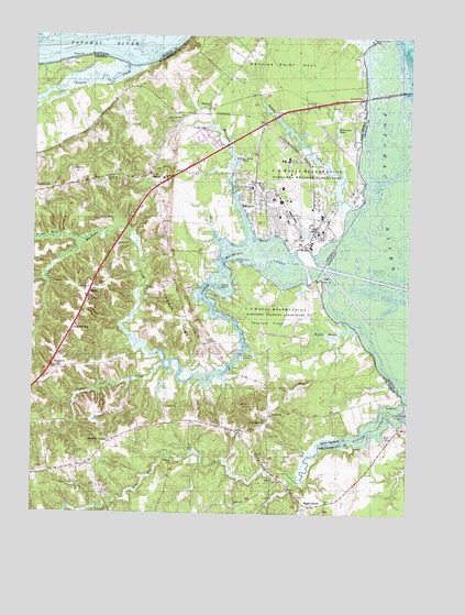
Dahlgren, VA USGS Topographic Map
Click on map above to begin viewing in our Map Viewer.

This topographic map contains these locations and features:
Feature Name Type Latitude Longitude GNIS ID View Map
AldenPopulated PlaceN38.2743°W77.0719°1749172View Map
AllnutPopulated PlaceN38.3082°W77.1058°1492462View Map
Baber PointCapeN38.3112°W77.0291°1462639View Map
Berrys WharfLocaleN38.3215°W77.0583°1478043View Map
Black MarshSwampN38.2929°W77.0284°1463488View Map
Brick House WharfLocaleN38.3173°W77.0636°1478044View Map
Bumbrey CemeteryCemeteryN38.3373°W77.1005°1464088View Map
Carruthers CornerPopulated PlaceN38.2687°W77.0986°1477179View Map
Chestnut HillPopulated PlaceN38.2993°W77.1108°1492756View Map
Chotank CreekStreamN38.3673°W77.0936°1464875View Map
Company 2BuildingN38.3394°W77.0650°2075320View Map
DahlgrenPopulated PlaceN38.3312°W77.0511°1465571View Map
Dahlgren Census Designated PlaceCensusN38.3442°W77.0623°2389388View Map
Dahlgren Center Census Designated PlaceCensusN38.3397°W77.0323°2630627View Map
Dahlgren DistrictCivilN38.3112°W77.0550°1927170View Map
Dahlgren Naval Surface Warfare Center AirportAirportN38.3323°W77.0395°2675625View Map
Dahlgren Post OfficePost OfficeN38.3312°W77.0465°2519602View Map
Dahlgren Rescue Station 2BuildingN38.3394°W77.0693°2331686View Map
Dahlgren United Methodist ChurchChurchN38.3332°W77.0500°1749177View Map
Deep CreekStreamN38.3215°W77.0630°1465700View Map
Frank LandingLocaleN38.3012°W77.0558°1478039View Map
Gambo CreekStreamN38.3304°W77.0191°1466967View Map
Good Hope Baptist ChurchChurchN38.2737°W77.0472°1467211View Map
Good Hope Baptist Church CemeteryCemeteryN38.2743°W77.0469°1749182View Map
Grace Presbyterian ChurchChurchN38.2938°W77.1200°2677321View Map
Harry W Nice Memorial BridgeBridgeN38.3601°W77.0055°1467796View Map
Hideaway PondReservoirN38.3490°W77.0232°1468000View Map
Hoge WharfLocaleN38.3226°W77.0500°1478038View Map
HooesPopulated PlaceN38.3573°W77.0669°1493106View Map
Howland PointCapeN38.3168°W77.0561°1468338View Map
King George Fire and Rescue Company 2 DahlgrenBuildingN38.3394°W77.0651°2331715View Map
King George PointCapeN38.2771°W77.0016°1469008View Map
Little Ark Baptist Church CemeteryCemeteryN38.3546°W77.0775°1749193View Map
Little Ark ChurchChurchN38.3537°W77.0761°1469455View Map
Little Ferry LandingLocaleN38.2915°W77.0547°1493207View Map
Long PointCapeN38.2868°W77.0664°1478040View Map
Lucas CemeteryCemeteryN38.2704°W77.0458°1469928View Map
Maple GrovePopulated PlaceN38.2518°W77.0314°1493246View Map
Mildale CemeteryCemeteryN38.2629°W77.0775°1470453View Map
Naval District Washington Fire Department DahlgrenBuildingN38.3277°W77.0373°2331776View Map
Naval Surface Warfare Center Dahlgren MainsideMilitaryN38.3406°W77.0327°2511952View Map
Naval Surface Warfare Center Pumpkin AnnexMilitaryN38.2996°W77.0422°2512434View Map
NindePopulated PlaceN38.2712°W77.0561°1493349View Map
Ninde Post OfficePost OfficeN38.2741°W77.0722°2766481View Map
Oakland CemeteryCemeteryN38.3376°W77.0866°1749202View Map
Oakland ChurchChurchN38.3379°W77.0811°1471783View Map
OwensPopulated PlaceN38.3387°W77.0864°1471988View Map
Oyster Shell LandingLocaleN38.3093°W77.0691°1749203View Map
Pepper Mill CreekStreamN38.3218°W77.1075°1472199View Map
Persimmon PointCapeN38.3746°W77.0119°1472218View Map
Pine Hill CreekStreamN38.2587°W77.0369°1472359View Map
Poplar Neck CreekStreamN38.2893°W77.0814°1472658View Map
Potomac Elementary SchoolSchoolN38.3362°W77.0530°1472711View Map
Pumpkin NeckCapeN38.3007°W77.0761°1472857View Map
Rescue Squad Station 2BuildingN38.3392°W77.0689°2075323View Map
Round Hill Baptist Church CemeteryCemeteryN38.2521°W77.0572°1749207View Map
Round Hill ChurchChurchN38.2518°W77.0561°1473579View Map
Sacred Heart ChapelChurchN38.3285°W77.0439°1749208View Map
Saint Pauls ChurchChurchN38.3323°W77.1250°1749210View Map
Saint Pauls Episcopal Church CemeteryCemeteryN38.3328°W77.1249°1749211View Map
Sharp Hill CemeteryCemeteryN38.2587°W77.0425°1474449View Map
Spy Hill CemeteryCemeteryN38.2826°W77.0389°1475038View Map
Stony PointCapeN38.2787°W77.0028°1475213View Map
Stuart PointCapeN38.3690°W77.1114°1475262View Map
TetotumPopulated PlaceN38.2760°W77.0453°1493696View Map
Tetotum FlatsFlatN38.3001°W77.0455°1475550View Map
Union Bethel Baptist Church CemeteryCemeteryN38.2882°W77.1166°1749219View Map
Union Bethel ChurchChurchN38.2879°W77.1161°1476021View Map
United States Naval Proving Grounds DamDamN38.3535°W77.0414°1490194View Map
United States Naval Proving Grounds PondReservoirN38.3535°W77.0414°1490195View Map
Upper Machodoc CreekStreamN38.3146°W77.0280°1476117View Map
WGRQ-FM (Colonial Beach)TowerN38.2596°W77.0250°1502623View Map
Williams CreekStreamN38.3226°W77.0525°1476763View Map
Wood IslandIslandN38.3090°W77.0619°1476929View Map

Note: Coordinates in the location and feature list above are referenced to NAD83 datum.


Copyright (C) 2008-2024 Ryan Niemi / Sunset Dynamics ... All Rights Reserved