TopoQuest Logo
Do you find TopoQuest useful?
Help keep TopoQuest running and adding new maps/features by donating!
Bitcoin:  19c7KJd3qBynnjoSw5npx9KScwjBe4ifkT
Litecoin:  LXs6TkuXGGXo1vDsWCkWVdjQX94eUKd6ui
Home View Maps Find Maps Find Places Resources & Links


Mathias Point, Virginia Topographic Map

USGS Map Title: Mathias Point, VA
USGS Map MRC: 38077D1
DRG (GeoTIFF) Download: o38077d1.tif


Neighboring USGS Topographic Map Quads:


  Indian Head, MD  
38077E2
 

  Port Tobacco, MD  
38077E1
 

  La Plata, MD  
38076E8
 

  Nanjemoy, MD  
38077D2
 

  Mathias Point, VA  
38077D1
 

  Popes Creek, MD  
38076D8
 

  King George, VA  
38077C2
 

  Dahlgren, VA  
38077C1
 

  Colonial Beach North, VA  
38076C8


Map MRC Location:

N39°
W78°
N39°
W77°
H8 H7 H6 H5 H4 H3 H2 H1
G8 G7 G6 G5 G4 G3 G2 G1
F8 F7 F6 F5 F4 F3 F2 F1
E8 E7 E6 E5 E4 E3 E2 E1
D8 D7 D6 D5 D4 D3 D2 D1
C8 C7 C6 C5 C4 C3 C2 C1
B8 B7 B6 B5 B4 B3 B2 B1
A8 A7 A6 A5 A4 A3 A2 A1
N38°
W78°
N38°
W77°

Mathias Point, VA USGS 1:24K Topographic Map Preview:
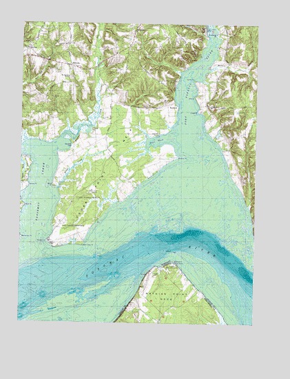
Mathias Point, VA USGS Topographic Map
Click on map above to begin viewing in our Map Viewer.

This topographic map contains these locations and features:
Feature Name Type Latitude Longitude GNIS ID View Map
Balls PointCapeN38.4326°W77.1069°583007View Map
Benny Gray PointCapeN38.4104°W77.1241°583157View Map
Blossom PointCapeN38.4082°W77.1097°583297View Map
Blossom Point Proving GroundsLocaleN38.4271°W77.0894°1676970View Map
Bluff PointCapeN38.4237°W77.1228°583306View Map
Bluff Point CoveBayN38.4282°W77.1241°1676972View Map
BrentlandPopulated PlaceN38.4654°W77.0408°589808View Map
Bristol (historical)Populated PlaceN38.4701°W77.0261°1676976View Map
Burgess CreekStreamN38.4479°W77.1069°583484View Map
Cedar GrovePopulated PlaceN38.4782°W77.0747°1676986View Map
Cedar Point NeckCapeN38.4396°W77.0805°583669View Map
Cedar Point Neck School (historical)SchoolN38.4712°W77.0775°1676987View Map
Chapel PointCapeN38.4640°W77.0291°583694View Map
Chapel PointPopulated PlaceN38.4637°W77.0289°1676989View Map
Chapel Point State ParkParkN38.4693°W77.0139°1676990View Map
Charles CountyCivilN38.4737°W77.0135°1676992View Map
ComptonPopulated PlaceN38.4512°W77.1144°588891View Map
Deep PointCapeN38.4698°W77.0316°584067View Map
District 2, Hill TopCivilN38.4619°W77.0952°1929533View Map
Fourth PointCapeN38.4765°W77.0322°584468View Map
Goose Bay MarinaLocaleN38.4540°W77.0508°584645View Map
Goose CreekBayN38.4518°W77.0522°584650View Map
Gumtree CoveBayN38.4485°W77.1003°584796View Map
Halls PointCapeN38.4162°W77.1078°1677036View Map
Harry Diamond LaboratoriesLocaleN38.4146°W77.0966°592434View Map
Henson LandingLocaleN38.4737°W77.0428°1677040View Map
Hill TopPopulated PlaceN38.4890°W77.1219°590470View Map
Kings CreekStreamN38.4310°W77.1050°585313View Map
Lanseair Farms AirportAirportN38.4613°W77.0462°595310View Map
Leonardtown Volunteer Rescue Squad Company 19BuildingN38.4997°W77.0714°2086968View Map
Mathias PointCapeN38.4004°W77.0422°1470184View Map
Mathias Point NeckCapeN38.3865°W77.0455°1470185View Map
Melody AcresPopulated PlaceN38.4835°W77.0914°1677078View Map
Mill RunStreamN38.4754°W77.0839°585876View Map
Mount AirPopulated PlaceN38.4357°W77.0064°1677082View Map
Mount Bethel Recreation CenterLocaleN38.3993°W77.0428°1470814View Map
Nanjemoy CreekStreamN38.4029°W77.1178°586137View Map
Penn ManorPopulated PlaceN38.4932°W77.0430°1677115View Map
Port Tobacco MarinaLocaleN38.4976°W77.0264°586670View Map
Port Tobacco RiverStreamN38.4423°W77.0286°582842View Map
Potomac ShoresPopulated PlaceN38.4876°W77.0186°1677122View Map
Saint Ignatius CemeteryCemeteryN38.4653°W77.0243°1677136View Map
Saint Ignatius ChurchChurchN38.4657°W77.0233°587010View Map
Simms LandingPopulated PlaceN38.4862°W77.0291°591292View Map
Sutton AcresPopulated PlaceN38.4971°W77.0200°1677155View Map
Tanners PointCapeN38.4321°W77.1208°587693View Map
The Welcome MissionChurchN38.4771°W77.0997°587759View Map
Upper Cedar PointCapeN38.4076°W77.0914°587976View Map
Warehouse PointCapeN38.4954°W77.0205°588047View Map
WelcomeLocaleN38.4818°W77.0983°588107View Map
Welcome AcresPopulated PlaceN38.4807°W77.1041°1677178View Map
Welcome Post OfficePost OfficeN38.4828°W77.0983°1677180View Map
Wills BranchStreamN38.4818°W77.0244°588266View Map
Wills Island (historical)IslandN38.4832°W77.0261°1677186View Map
Windmill PointCapeN38.4446°W77.0416°588291View Map
Zion CemeteryCemeteryN38.4898°W77.1216°1677191View Map
Zion ChurchChurchN38.4887°W77.1219°588376View Map

Note: Coordinates in the location and feature list above are referenced to NAD83 datum.


Copyright (C) 2008-2024 Ryan Niemi / Sunset Dynamics ... All Rights Reserved