TopoQuest Logo
Do you find TopoQuest useful?
Help keep TopoQuest running and adding new maps/features by donating!
Bitcoin:  19c7KJd3qBynnjoSw5npx9KScwjBe4ifkT
Litecoin:  LXs6TkuXGGXo1vDsWCkWVdjQX94eUKd6ui
Home View Maps Find Maps Find Places Resources & Links


Snow Hill, North Carolina Topographic Map

USGS Map Title: Snow Hill, NC
USGS Map MRC: 35077D6
DRG (GeoTIFF) Download: o35077d6.tif


Neighboring USGS Topographic Map Quads:


  Stantonsburg, NC  
35077E7
 

  Walstonburg, NC  
35077E6
 

  Farmville, NC  
35077E5
 

  Jason, NC  
35077D7
 

  Snow Hill, NC  
35077D6
 

  Hookerton, NC  
35077D5
 

  La Grange, NC  
35077C7
 

  Falling Creek, NC  
35077C6
 

  Kinston, NC  
35077C5


Map MRC Location:

N36°
W78°
N36°
W77°
H8 H7 H6 H5 H4 H3 H2 H1
G8 G7 G6 G5 G4 G3 G2 G1
F8 F7 F6 F5 F4 F3 F2 F1
E8 E7 E6 E5 E4 E3 E2 E1
D8 D7 D6 D5 D4 D3 D2 D1
C8 C7 C6 C5 C4 C3 C2 C1
B8 B7 B6 B5 B4 B3 B2 B1
A8 A7 A6 A5 A4 A3 A2 A1
N35°
W78°
N35°
W77°

Snow Hill, NC USGS 1:24K Topographic Map Preview:
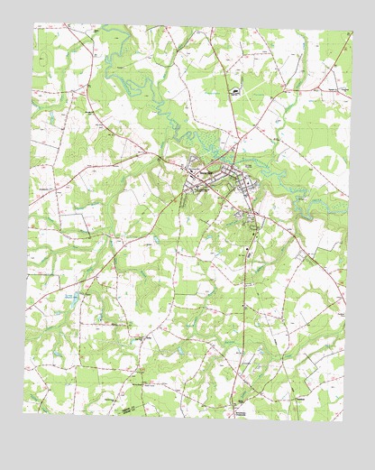
Snow Hill, NC USGS Topographic Map
Click on map above to begin viewing in our Map Viewer.

This topographic map contains these locations and features:
Feature Name Type Latitude Longitude GNIS ID View Map
ArbaPopulated PlaceN35.4013°W77.7022°980271View Map
Arba Rural Fire AssociationBuildingN35.4032°W77.6964°2639407View Map
Beargarden PocosinSwampN35.4810°W77.6658°980747View Map
Bests ChurchChurchN35.4977°W77.7261°1003740View Map
Branch Grove ChurchChurchN35.3799°W77.7141°1003748View Map
Brown ChapelChurchN35.3802°W77.6644°1003751View Map
Browntown CrossroadsPopulated PlaceN35.3771°W77.6675°1023850View Map
Friendship ChurchChurchN35.4818°W77.6272°1003743View Map
GlenfieldPopulated PlaceN35.3821°W77.6352°1023990View Map
Green County Juvenile RestitutionBuildingN35.4499°W77.6839°2130880View Map
Greene Central High SchoolSchoolN35.4506°W77.6685°1003742View Map
Greene Central Junior High SchoolSchoolN35.4818°W77.6705°1006635View Map
Greene CountyCivilN35.4850°W77.6758°1008557View Map
Greene County Emergency Medical ServicesBuildingN35.4535°W77.6829°2720685View Map
Greene County Sheriff's OfficeBuildingN35.4554°W77.6699°2130888View Map
Grimsley ChurchChurchN35.4807°W77.6305°1024011View Map
Harrells ChurchChurchN35.4713°W77.7253°1003741View Map
Hill ViewPopulated PlaceN35.4404°W77.6672°1023551View Map
Horsepen BranchStreamN35.4021°W77.6822°1024045View Map
Hull Road ChurchChurchN35.4002°W77.7036°1003749View Map
Jacks ForkStreamN35.4274°W77.7372°987481View Map
Jerusalem ChurchChurchN35.4477°W77.7405°987587View Map
Lenoir Community College - Snow HillSchoolN35.4758°W77.6705°1003745View Map
Lewis BranchStreamN35.4754°W77.7497°988374View Map
Liberty ChurchChurchN35.4474°W77.6644°1003746View Map
McCoy ChapelChurchN35.3854°W77.7030°1003750View Map
Mill RunStreamN35.4763°W77.6986°1024153View Map
Mink Point BranchStreamN35.4324°W77.7186°1025995View Map
Newbern SchoolSchoolN35.4135°W77.7416°991117View Map
North Carolina State Highway Patrol Troop C District 5 SubstationBuildingN35.4553°W77.6698°2131046View Map
Panther Swamp CreekStreamN35.4391°W77.6569°1024206View Map
Poorhouse RunStreamN35.4366°W77.6578°1024234View Map
Reedy BranchStreamN35.4360°W77.7166°993164View Map
Shepherd RunStreamN35.4416°W77.6430°1024297View Map
Snow HillPopulated PlaceN35.4516°W77.6811°995074View Map
Snow Hill CemeteryCemeteryN35.4393°W77.6598°1003747View Map
Snow Hill Elementary SchoolSchoolN35.4504°W77.6644°1006634View Map
Snow Hill Emergency Medical ServicesBuildingN35.4537°W77.6688°2720684View Map
Snow Hill Post OfficePost OfficeN35.4435°W77.6632°2773995View Map
Snow Hill Rural Fire DepartmentBuildingN35.4512°W77.6653°2638437View Map
Sowell RunStreamN35.3949°W77.6528°1003752View Map
Spring BranchStreamN35.4427°W77.7186°1024315View Map
Suggs SchoolSchoolN35.4271°W77.6358°995667View Map
Suggs SidingLocaleN35.4102°W77.6564°995668View Map
Town of Snow HillCivilN35.4505°W77.6768°2407362View Map
Township of JasonCivilN35.3955°W77.7369°1026724View Map
Township of Snow HillCivilN35.4626°W77.6989°1026728View Map
Turnage MillpondReservoirN35.4120°W77.7305°998949View Map
Turnage Millpond DamDamN35.4135°W77.7297°998948View Map
Tyson MarshStreamN35.4682°W77.6941°1024370View Map
Washington BranchStreamN35.4993°W77.6880°1003665View Map
West Greene SchoolSchoolN35.4541°W77.6864°1003744View Map
Whiteoaks SchoolSchoolN35.4788°W77.7453°997245View Map

Note: Coordinates in the location and feature list above are referenced to NAD83 datum.


Copyright (C) 2008-2024 Ryan Niemi / Sunset Dynamics ... All Rights Reserved