TopoQuest Logo
Do you find TopoQuest useful?
Help keep TopoQuest running and adding new maps/features by donating!
Bitcoin:  19c7KJd3qBynnjoSw5npx9KScwjBe4ifkT
Litecoin:  LXs6TkuXGGXo1vDsWCkWVdjQX94eUKd6ui
Home View Maps Find Maps Find Places Resources & Links


Farmville, North Carolina Topographic Map

USGS Map Title: Farmville, NC
USGS Map MRC: 35077E5
DRG (GeoTIFF) Download: o35077e5.tif


Neighboring USGS Topographic Map Quads:


  Fountain, NC  
35077F6
 

  Falkland, NC  
35077F5
 

  Greenville NW, NC  
35077F4
 

  Walstonburg, NC  
35077E6
 

  Farmville, NC  
35077E5
 

  Greenville SW, NC  
35077E4
 

  Snow Hill, NC  
35077D6
 

  Hookerton, NC  
35077D5
 

  Ayden, NC  
35077D4


Map MRC Location:

N36°
W78°
N36°
W77°
H8 H7 H6 H5 H4 H3 H2 H1
G8 G7 G6 G5 G4 G3 G2 G1
F8 F7 F6 F5 F4 F3 F2 F1
E8 E7 E6 E5 E4 E3 E2 E1
D8 D7 D6 D5 D4 D3 D2 D1
C8 C7 C6 C5 C4 C3 C2 C1
B8 B7 B6 B5 B4 B3 B2 B1
A8 A7 A6 A5 A4 A3 A2 A1
N35°
W78°
N35°
W77°

Farmville, NC USGS 1:24K Topographic Map Preview:
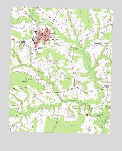
Farmville, NC USGS Topographic Map
Click on map above to begin viewing in our Map Viewer.

This topographic map contains these locations and features:
Feature Name Type Latitude Longitude GNIS ID View Map
Advent ChurchChurchN35.5360°W77.6028°1004045View Map
Ballards CrossroadPopulated PlaceN35.5479°W77.5033°1024317View Map
Beacon ChurchChurchN35.6243°W77.5919°1004042View Map
Bell ArthurPopulated PlaceN35.5904°W77.5136°1023414View Map
Bell Arthur Census Designated PlaceCensusN35.5912°W77.5127°2584308View Map
Bell Arthur Volunteer Fire DepartmentBuildingN35.5913°W77.5132°2638790View Map
Bellarthur Post OfficePost OfficeN35.5906°W77.5129°2505332View Map
BirchwoodPopulated PlaceN35.6040°W77.5944°1005868View Map
Black SwampStreamN35.6199°W77.5997°1023838View Map
Bright Leaf Shopping CenterLocaleN35.5807°W77.5900°1018731View Map
Caswell CenterBuildingN35.6113°W77.6169°1024510View Map
Community ChurchChurchN35.5485°W77.5047°1004049View Map
Contentea CampgroundLocaleN35.5374°W77.5164°1007461View Map
Crafts Airport (historical)AirportN35.6018°W77.6097°997944View Map
En-Power Disciple Church MinistriesChurchN35.5821°W77.5906°2633149View Map
FarmvillePopulated PlaceN35.5954°W77.5852°1020222View Map
Farmville Community CenterBuildingN35.5935°W77.5902°1007456View Map
Farmville Country ClubLocaleN35.6065°W77.5864°1007459View Map
Farmville Emergency Medical ServicesBuildingN35.6028°W77.5912°2720390View Map
Farmville Fire DepartmentBuildingN35.5976°W77.5846°2638061View Map
Farmville Healthcare CenterHospitalN35.5790°W77.5943°2505780View Map
Farmville Middle SchoolSchoolN35.5935°W77.5727°1004056View Map
Farmville Police DepartmentBuildingN35.5991°W77.5848°2130865View Map
Farmville Police DepartmentBuildingN35.6031°W77.5780°2131037View Map
Farmville Post OfficePost OfficeN35.5978°W77.5844°2773844View Map
Farmville Square Shopping CenterLocaleN35.5882°W77.6058°1007457View Map
Farmville Town HallBuildingN35.5979°W77.5850°1004052View Map
Flanagan FieldAirportN35.5580°W77.5593°2679172View Map
Forest Hills CemeteryCemeteryN35.6002°W77.5794°1004054View Map
H B Sugg Elementary SchoolSchoolN35.5940°W77.5750°1024873View Map
Half Moon PocosinSwampN35.5071°W77.5608°1004043View Map
Harpers ChapelChurchN35.5510°W77.6044°1004047View Map
High SchoolSchoolN35.5940°W77.5683°1024481View Map
Hollywood CemeteryCemeteryN35.5974°W77.5761°1004055View Map
J Y Monk ParkParkN35.6054°W77.5927°1007460View Map
Jacob BranchStreamN35.6138°W77.5944°1024060View Map
Kittrell HillPopulated PlaceN35.6093°W77.5436°1005866View Map
Lakeside Fore Mobile Home ParkPopulated PlaceN35.6128°W77.5086°2505483View Map
Lanes Crossroads - Mobile Home ParkPopulated PlaceN35.5601°W77.5488°2505485View Map
LizziePopulated PlaceN35.5066°W77.6169°1006282View Map
MarlboroPopulated PlaceN35.5802°W77.5919°989350View Map
Marlboro ChurchChurchN35.5715°W77.5761°1004048View Map
Marlboro ForestPopulated PlaceN35.5854°W77.6116°1005864View Map
Matthews Mobile Home ParkPopulated PlaceN35.6029°W77.5345°2505495View Map
Middle SchoolSchoolN35.5935°W77.5727°1024482View Map
Middle SwampStreamN35.5141°W77.5091°1024144View Map
Mount Herman ChurchChurchN35.5052°W77.6214°1004046View Map
Moyes ChapelChurchN35.5549°W77.5547°1024493View Map
Municipal Athletic ParkParkN35.6029°W77.5847°1007458View Map
North RidgePopulated PlaceN35.6190°W77.5858°1005867View Map
Oldwoman BranchStreamN35.5921°W77.5455°991627View Map
Patrick ChapelChurchN35.5141°W77.5927°1024492View Map
Pine Grove ApartmentsPopulated PlaceN35.5852°W77.5875°1005865View Map
Pinelog BranchStreamN35.5849°W77.5330°1024220View Map
Pleasant Mount Post OfficePost OfficeN35.5432°W77.5236°1025003View Map
Saint Johns ChurchChurchN35.5863°W77.5941°1004053View Map
Saint Pauls ChurchChurchN35.5513°W77.6044°1004051View Map
Sam D Bundy Elementary SchoolSchoolN35.5950°W77.5765°1024874View Map
Sandy RunStreamN35.5324°W77.5561°1024290View Map
Town of FarmvilleCivilN35.5954°W77.5913°2406493View Map
Township of FarmvilleCivilN35.5945°W77.5912°1027060View Map
Township of OldsCivilN35.5080°W77.6160°1026725View Map
Tysons ChapelChurchN35.5424°W77.6186°1004050View Map
Tysons ChurchChurchN35.6046°W77.5286°1004057View Map
Waterside ChurchChurchN35.5246°W77.5244°1004044View Map
Watkins Way Mobile Home ParkPopulated PlaceN35.6173°W77.6217°2505684View Map
WFAGTowerN35.6046°W77.5747°1024694View Map
WGHB-AM (Farmville)TowerN35.6049°W77.5744°1018465View Map
Willow CreekPopulated PlaceN35.5179°W77.5297°1006409View Map
WRQR-FM (Farmville)TowerN35.6035°W77.5739°1018284View Map
WUNK-TV (Greenville)TowerN35.5529°W77.6014°1024424View Map

Note: Coordinates in the location and feature list above are referenced to NAD83 datum.


Copyright (C) 2008-2024 Ryan Niemi / Sunset Dynamics ... All Rights Reserved