TopoQuest Logo
Do you find TopoQuest useful?
Help keep TopoQuest running and adding new maps/features by donating!
Bitcoin:  19c7KJd3qBynnjoSw5npx9KScwjBe4ifkT
Litecoin:  LXs6TkuXGGXo1vDsWCkWVdjQX94eUKd6ui
Home View Maps Find Maps Find Places Resources & Links


Clinton, Illinois Topographic Map

USGS Map Title: Clinton, IL
USGS Map MRC: 40088B8
DRG (GeoTIFF) Download: o40088b8.tif


Neighboring USGS Topographic Map Quads:


  Funks Grove, IL  
40089C1
 

  Heyworth, IL  
40088C8
 

  Le Roy, IL  
40088C7
 

  Waynesville East, IL  
40089B1
 

  Clinton, IL  
40088B8
 

  De Witt, IL  
40088B7
 

  Kenney, IL  
40089A1
 

  Maroa, IL  
40088A8
 

  Weldon West, IL  
40088A7


Map MRC Location:

N41°
W89°
N41°
W88°
H8 H7 H6 H5 H4 H3 H2 H1
G8 G7 G6 G5 G4 G3 G2 G1
F8 F7 F6 F5 F4 F3 F2 F1
E8 E7 E6 E5 E4 E3 E2 E1
D8 D7 D6 D5 D4 D3 D2 D1
C8 C7 C6 C5 C4 C3 C2 C1
B8 B7 B6 B5 B4 B3 B2 B1
A8 A7 A6 A5 A4 A3 A2 A1
N40°
W89°
N40°
W88°

Clinton, IL USGS 1:24K Topographic Map Preview:
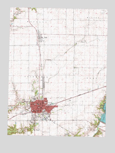
Clinton, IL USGS Topographic Map
Click on map above to begin viewing in our Map Viewer.

This topographic map contains these locations and features:
Feature Name Type Latitude Longitude GNIS ID View Map
Assembly of God ChurchChurchN40.1461°W88.9665°1820747View Map
Calvary United Pentecostal ChurchChurchN40.1495°W88.9590°1820748View Map
Christ Lutheran ChurchChurchN40.1470°W88.9662°1820749View Map
Church of GodChurchN40.1600°W88.9526°1820750View Map
City of ClintonCivilN40.1470°W88.9634°2393568View Map
ClintonPopulated PlaceN40.1536°W88.9645°406261View Map
Clinton City HallBuildingN40.1534°W88.9612°1720066View Map
Clinton Fire DepartmentBuildingN40.1533°W88.9615°2682099View Map
Clinton High SchoolSchoolN40.1459°W88.9779°1720074View Map
Clinton Junior High SchoolSchoolN40.1559°W88.9617°1808822View Map
Clinton Lake DamDamN40.1394°W88.8782°1692384View Map
Clinton Outdoor Theater (historical)LocaleN40.1602°W88.9233°2741714View Map
Clinton Police DepartmentBuildingN40.1534°W88.9615°2759087View Map
Clinton Post OfficePost OfficeN40.1529°W88.9620°1720068View Map
Crum CemeteryCemeteryN40.2443°W88.9896°406857View Map
De Witt CountyCivilN40.1746°W88.9041°426598View Map
De Witt County CourthouseBuildingN40.1525°W88.9604°1720067View Map
Dewitt County Sheriff's OfficeBuildingN40.1540°W88.9611°2758993View Map
Douglas Elementary SchoolSchoolN40.1528°W88.9501°407351View Map
Downey ParkParkN40.1492°W88.9681°1720069View Map
First Baptist ChurchChurchN40.1509°W88.9726°1820751View Map
First Christian ChurchChurchN40.1531°W88.9623°1820752View Map
First Church of GodChurchN40.1520°W88.9520°1820753View Map
Free Methodist ChurchChurchN40.1573°W88.9537°1820754View Map
Hill CemeteryCemeteryN40.1300°W88.9631°410251View Map
John Scharff AirportAirportN40.1674°W88.8975°2679035View Map
Kingdom Hall of Jehovahs WitnessesChurchN40.1534°W88.9437°1820755View Map
Lincoln SchoolSchoolN40.1492°W88.9642°412160View Map
Memorial Park CemeteryCemeteryN40.1628°W88.9679°413388View Map
Oak Park CemeteryCemeteryN40.1620°W88.9693°1951266View Map
Prairie Center ChurchChurchN40.1920°W88.9162°416098View Map
Presbyterian Church of ClintonChurchN40.1556°W88.9601°1820756View Map
Saint Johns Catholic ChurchChurchN40.1564°W88.9590°1820757View Map
Saint Johns SchoolSchoolN40.1564°W88.9584°1720073View Map
Thorp AirportAirportN40.2162°W88.9247°427171View Map
Township of ClintoniaCivilN40.1765°W88.9731°428822View Map
Township of WapellaCivilN40.2482°W88.9762°429892View Map
Village of WapellaCivilN40.2216°W88.9612°2400092View Map
WapellaPopulated PlaceN40.2203°W88.9620°420513View Map
Wapella Fire Protection DistrictBuildingN40.2205°W88.9608°2681832View Map
Wapella High SchoolSchoolN40.2256°W88.9581°1720071View Map
Wapella Post OfficePost OfficeN40.2205°W88.9616°2788832View Map
Warner Hospital and Health ServicesHospitalN40.1484°W88.9647°1720070View Map
Washington Elementary SchoolSchoolN40.1556°W88.9659°420596View Map
Weaver CemeteryCemeteryN40.1598°W88.9813°420674View Map
Webster Elementary SchoolSchoolN40.1581°W88.9529°1720072View Map
Woodlawn CemeteryCemeteryN40.1609°W88.9662°421452View Map

Note: Coordinates in the location and feature list above are referenced to NAD83 datum.


Copyright (C) 2008-2024 Ryan Niemi / Sunset Dynamics ... All Rights Reserved