TopoQuest Logo
Do you find TopoQuest useful?
Help keep TopoQuest running and adding new maps/features by donating!
Bitcoin:  19c7KJd3qBynnjoSw5npx9KScwjBe4ifkT
Litecoin:  LXs6TkuXGGXo1vDsWCkWVdjQX94eUKd6ui
Home View Maps Find Maps Find Places Resources & Links


Bay City, Wisconsin Topographic Map

USGS Map Title: Bay City, WI
USGS Map MRC: 44092E4
DRG (GeoTIFF) Download: o44092e4.tif


Neighboring USGS Topographic Map Quads:


  Diamond Bluff East, WI  
44092F5
 

  Ellsworth, WI  
44092F4
 

  Waverly, WI  
44092F3
 

  Red Wing, MN  
44092E5
 

  Bay City, WI  
44092E4
 

  Maiden Rock, WI  
44092E3
 

  Goodhue East, MN  
44092D5
 

  Lake City NW, MN  
44092D4
 

  Lake City, MN  
44092D3


Map MRC Location:

N45°
W93°
N45°
W92°
H8 H7 H6 H5 H4 H3 H2 H1
G8 G7 G6 G5 G4 G3 G2 G1
F8 F7 F6 F5 F4 F3 F2 F1
E8 E7 E6 E5 E4 E3 E2 E1
D8 D7 D6 D5 D4 D3 D2 D1
C8 C7 C6 C5 C4 C3 C2 C1
B8 B7 B6 B5 B4 B3 B2 B1
A8 A7 A6 A5 A4 A3 A2 A1
N44°
W93°
N44°
W92°

Bay City, WI USGS 1:24K Topographic Map Preview:
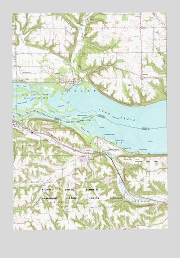
Bay City, WI USGS Topographic Map
Click on map above to begin viewing in our Map Viewer.

This topographic map contains these locations and features:
Feature Name Type Latitude Longitude GNIS ID View Map
Baldwin IslandIslandN44.5658°W92.4871°639596View Map
Bay CityPopulated PlaceN44.5855°W92.4505°1561318View Map
Bay City CemeteryCemeteryN44.5877°W92.4560°1964269View Map
Berean Baptist ChurchChurchN44.5500°W92.4972°2064770View Map
Bullard CreekStreamN44.5602°W92.4527°640629View Map
Catharine PassChannelN44.5725°W92.4574°1562808View Map
EsdailePopulated PlaceN44.6208°W92.4388°1564694View Map
Fishermans PointCapeN44.5655°W92.4488°1565023View Map
Forest Home Community ChurchChurchN44.6161°W92.3960°1565133View Map
Forest Home School (historical)SchoolN44.6164°W92.3963°1578325View Map
Friedrich PointCapeN44.5508°W92.4180°643959View Map
Frontenac Hills Apple FarmLocaleN44.5125°W92.4225°2651176View Map
Goose LakeBayN44.5833°W92.4944°1565648View Map
Greene PointCapeN44.5455°W92.3985°644434View Map
Grotes PondLakeN44.5439°W92.4241°644493View Map
Hartland ChurchChurchN44.6227°W92.3963°1566106View Map
Hedin Island ParkParkN44.5639°W92.4917°2064832View Map
Henry Henricks DamDamN44.5466°W92.4835°1776625View Map
Hiawatha Valley Baptist ChurchChurchN44.5606°W92.4958°2064766View Map
Isabelle CreekStreamN44.5794°W92.4374°1566992View Map
Jackson BluffCliffN44.6197°W92.4530°1567063View Map
Lily PondBayN44.5652°W92.4569°1568053View Map
Minnesota State Training School Entrance WallsParkN44.5597°W92.4972°2064804View Map
Mississippi National Golf LinksLocaleN44.5528°W92.4917°2064835View Map
Mount Frontenac Golf CourseLocaleN44.5139°W92.3833°2064778View Map
Mount Frontenac Ski AreaLocaleN44.5139°W92.3833°2064777View Map
Oak Hill Mobile Home ParkPopulated PlaceN44.5889°W92.4575°2611798View Map
OakridgePopulated PlaceN44.5883°W92.3955°1577759View Map
Oakvale School (historical)SchoolN44.6127°W92.4919°1578353View Map
Presbyterian PointCapeN44.5542°W92.4267°2778773View Map
Rattlesnake BluffCliffN44.5402°W92.4044°649845View Map
Red Wing Regional AirportAirportN44.5892°W92.4814°1582526View Map
Richard J Dorer Memorial Hardwood State ForestForestN44.5236°W92.4357°639172View Map
Sawdust BarBarN44.5647°W92.4402°1573746View Map
Scherf CemeteryCemeteryN44.5111°W92.4778°2064985View Map
Tabor CemeteryCemeteryN44.5866°W92.3952°1964286View Map
Tabor ChurchChurchN44.5869°W92.3952°1575219View Map
Town of IsabelleCivilN44.5818°W92.4325°1583438View Map
Township of WacoutaCivilN44.5523°W92.4153°665888View Map
Village of Bay CityCivilN44.5871°W92.4569°1582763View Map
WacoutaPopulated PlaceN44.5450°W92.4349°653706View Map
Wacouta BayBayN44.5572°W92.4419°653707View Map
Wacouta BeachPopulated PlaceN44.5458°W92.4105°654990View Map
Wacouta CemeteryCemeteryN44.5478°W92.4291°2066837View Map
Wacouta CemeteryCemeteryN44.5479°W92.4290°2066200View Map

Note: Coordinates in the location and feature list above are referenced to NAD83 datum.


Copyright (C) 2008-2024 Ryan Niemi / Sunset Dynamics ... All Rights Reserved