TopoQuest Logo
Do you find TopoQuest useful?
Help keep TopoQuest running and adding new maps/features by donating!
Bitcoin:  19c7KJd3qBynnjoSw5npx9KScwjBe4ifkT
Litecoin:  LXs6TkuXGGXo1vDsWCkWVdjQX94eUKd6ui
Home View Maps Find Maps Find Places Resources & Links


Mason, Kentucky Topographic Map

USGS Map Title: Mason, KY
USGS Map MRC: 38084E5
DRG (GeoTIFF) Download: o38084e5.tif


Neighboring USGS Topographic Map Quads:


  Elliston, KY  
38084F6
 

  Williamstown, KY  
38084F5
 

  Goforth, KY  
38084F4
 

  Lawrenceville, KY  
38084E6
 

  Mason, KY  
38084E5
 

  Berry, KY  
38084E4
 

  New Columbus, KY  
38084D6
 

  Sadieville, KY  
38084D5
 

  Breckinridge, KY  
38084D4


Map MRC Location:

N39°
W85°
N39°
W84°
H8 H7 H6 H5 H4 H3 H2 H1
G8 G7 G6 G5 G4 G3 G2 G1
F8 F7 F6 F5 F4 F3 F2 F1
E8 E7 E6 E5 E4 E3 E2 E1
D8 D7 D6 D5 D4 D3 D2 D1
C8 C7 C6 C5 C4 C3 C2 C1
B8 B7 B6 B5 B4 B3 B2 B1
A8 A7 A6 A5 A4 A3 A2 A1
N38°
W85°
N38°
W84°

Mason, KY USGS 1:24K Topographic Map Preview:
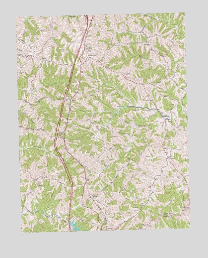
Mason, KY USGS Topographic Map
Click on map above to begin viewing in our Map Viewer.

This topographic map contains these locations and features:
Feature Name Type Latitude Longitude GNIS ID View Map
Ackman CemeteryCemeteryN38.5292°W84.5302°485744View Map
Anness CemeteryCemeteryN38.5378°W84.5606°2542570View Map
Anness CemeteryCemeteryN38.5109°W84.5377°485963View Map
BlanchetPopulated PlaceN38.5198°W84.5716°507523View Map
Brewsaugh CemeteryCemeteryN38.5017°W84.5280°487867View Map
Brock CemeteryCemeteryN38.5081°W84.5435°487945View Map
Brooks CemeteryCemeteryN38.5128°W84.5377°487960View Map
Bruce CemeteryCemeteryN38.5592°W84.5074°488048View Map
Camp NorthwardLocaleN38.5637°W84.5169°488709View Map
Catlick CemeteryCemeteryN38.5759°W84.5166°489095View Map
Cherry Creek School (historical)SchoolN38.6016°W84.5778°2554090View Map
Cherry GrovePopulated PlaceN38.6017°W84.5705°507694View Map
Clark CemeteryCemeteryN38.6081°W84.5727°489535View Map
Collier CemeteryCemeteryN38.5687°W84.5369°489844View Map
Coopertown HillSummitN38.6194°W84.5384°2742186View Map
CordovaPopulated PlaceN38.5409°W84.5152°490094View Map
Corinth DivisionCivilN38.5291°W84.5685°1936950View Map
Corinth LakeReservoirN38.5009°W84.5834°490110View Map
Crouch CemeteryCemeteryN38.5770°W84.5280°490405View Map
Dunn CemeteryCemeteryN38.5523°W84.5297°491325View Map
Dunn Mazie RunStreamN38.5456°W84.5083°2742187View Map
Elizabeth ChurchChurchN38.5162°W84.5005°491636View Map
Grassy Run ChurchChurchN38.5993°W84.6051°493169View Map
HeekinPopulated PlaceN38.6003°W84.6144°508215View Map
HilltopPopulated PlaceN38.6053°W84.5733°508245View Map
Kentucky Veterans Cemetery NorthCemeteryN38.6106°W84.5783°2775095View Map
Lawrence CemeteryCemeteryN38.5556°W84.5455°496073View Map
Lawrence CemeteryCemeteryN38.5681°W84.5310°496074View Map
Lawrence CemeteryCemeteryN38.5903°W84.5441°496075View Map
Layton ChapelChurchN38.5290°W84.5258°496104View Map
Lystra ChurchChurchN38.5565°W84.5938°497397View Map
MasonPopulated PlaceN38.5762°W84.5852°497651View Map
Mason SchoolSchoolN38.5570°W84.5933°497662View Map
Moon CemeteryCemeteryN38.5598°W84.5324°498525View Map
Morgan CemeteryCemeteryN38.5292°W84.5060°498587View Map
Morgan CemeteryCemeteryN38.5423°W84.5272°498588View Map
Mount Oliver CemeteryCemeteryN38.5928°W84.6233°498799View Map
Mount Olivet ChurchChurchN38.6015°W84.6138°498809View Map
Mount Pleasant ChurchChurchN38.5745°W84.5269°498855View Map
North Fork Lick CreekStreamN38.5716°W84.5398°2742191View Map
Oak Ridge ChurchChurchN38.6065°W84.5263°499720View Map
Odors BottomFlatN38.5673°W84.5199°2742192View Map
Page CemeteryCemeteryN38.5467°W84.5180°500110View Map
Phillips CemeteryCemeteryN38.5717°W84.5094°500536View Map
Risen CemeteryCemeteryN38.6067°W84.5516°501966View Map
Saint Marys CemeteryCemeteryN38.5209°W84.5716°502689View Map
Sheriff CemeteryCemeteryN38.6167°W84.6097°503356View Map
Shiloh ChurchChurchN38.5273°W84.6116°503384View Map
Simpson RidgeRidgeN38.6092°W84.6172°503540View Map
South Fork Lick Creek BranchStreamN38.5692°W84.5227°503931View Map
Steger CemeteryCemeteryN38.5303°W84.6130°504327View Map
StringtownPopulated PlaceN38.5120°W84.5011°509150View Map
Webb CemeteryCemeteryN38.5437°W84.5147°506334View Map
Williamstown CreekStreamN38.6203°W84.5205°506838View Map
Windings CemeteryCemeteryN38.5467°W84.5449°506931View Map

Note: Coordinates in the location and feature list above are referenced to NAD83 datum.


Copyright (C) 2008-2024 Ryan Niemi / Sunset Dynamics ... All Rights Reserved