TopoQuest Logo
Do you find TopoQuest useful?
Help keep TopoQuest running and adding new maps/features by donating!
Bitcoin:  19c7KJd3qBynnjoSw5npx9KScwjBe4ifkT
Litecoin:  LXs6TkuXGGXo1vDsWCkWVdjQX94eUKd6ui
Home View Maps Find Maps Find Places Resources & Links


Milan, Wisconsin Topographic Map

USGS Map Title: Milan, WI
USGS Map MRC: 44090H2
DRG (GeoTIFF) Download: o44090h2.tif


Neighboring USGS Topographic Map Quads:


  Stetsonville, WI  
45090A3
 

  Corinth, WI  
45090A2
 

  Athens, WI  
45090A1
 

  Abbotsford, WI  
44090H3
 

  Milan, WI  
44090H2
 

  Wien, WI  
44090H1
 

  Spencer North, WI  
44090G3
 

  Little Rose, WI  
44090G2
 

  Stratford, WI  
44090G1


Map MRC Location:

N45°
W91°
N45°
W90°
H8 H7 H6 H5 H4 H3 H2 H1
G8 G7 G6 G5 G4 G3 G2 G1
F8 F7 F6 F5 F4 F3 F2 F1
E8 E7 E6 E5 E4 E3 E2 E1
D8 D7 D6 D5 D4 D3 D2 D1
C8 C7 C6 C5 C4 C3 C2 C1
B8 B7 B6 B5 B4 B3 B2 B1
A8 A7 A6 A5 A4 A3 A2 A1
N44°
W91°
N44°
W90°

Milan, WI USGS 1:24K Topographic Map Preview:
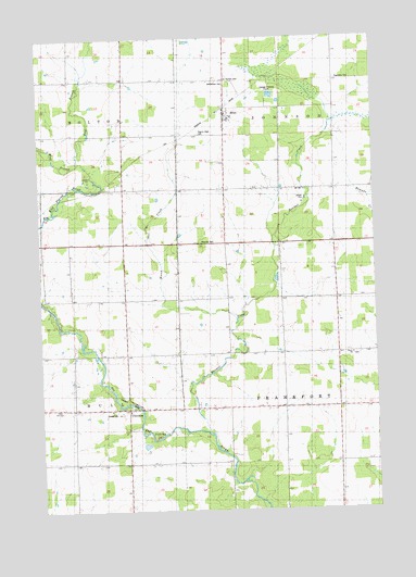
Milan, WI USGS Topographic Map
Click on map above to begin viewing in our Map Viewer.

This topographic map contains these locations and features:
Feature Name Type Latitude Longitude GNIS ID View Map
Ann's DairyLocaleN44.9725°W90.1792°2723391View Map
Bethlehem CemeteryCemeteryN44.9877°W90.1793°1561651View Map
CherokeePopulated PlaceN44.9022°W90.2179°1562981View Map
Cherokee ParkParkN44.9047°W90.2226°1562984View Map
Corinth Airport (historical)AirportN44.9994°W90.1496°1581865View Map
Dixon SchoolSchoolN44.9605°W90.1815°1564010View Map
East Branch Big Eau Pleine RiverStreamN44.9677°W90.2343°1564283View Map
Enmar DairyLocaleN44.9589°W90.1900°2723393View Map
Franklin School (historical)SchoolN44.9311°W90.1390°1876691View Map
Hidden Creek RanchLocaleN44.9461°W90.1669°2723401View Map
Hillcrest School (historical)SchoolN44.9019°W90.1799°1876698View Map
Hoffman FarmsLocaleN44.9708°W90.1819°2723372View Map
J M DairyLocaleN44.9508°W90.1822°2723392View Map
Marsh CreekStreamN44.9255°W90.1760°1569073View Map
MilanPopulated PlaceN44.9811°W90.1796°1569457View Map
Peace ChurchChurchN44.9158°W90.1340°1571115View Map
Pilgrim Rest CemeteryCemeteryN44.9744°W90.1901°1845227View Map
Ploeckelman FarmsLocaleN44.9875°W90.2044°2723368View Map
Randall CreekStreamN44.8955°W90.1887°1572056View Map
Rusk School (historical)SchoolN44.9311°W90.1985°1876734View Map
Saint Thomas CemeteryCemeteryN44.9883°W90.1790°1573587View Map
Schreiber AcresLocaleN44.9589°W90.1692°2723399View Map
Town of FrankfortCivilN44.9020°W90.1385°1583229View Map
Town of JohnsonCivilN44.9889°W90.1389°1583455View Map
Venzke DairyLocaleN44.9878°W90.2011°2723400View Map
West Branch Big Eau Pleine RiverStreamN44.9672°W90.2343°1576460View Map
Wright School (historical)SchoolN44.9633°W90.2187°1876763View Map

Note: Coordinates in the location and feature list above are referenced to NAD83 datum.


Copyright (C) 2008-2024 Ryan Niemi / Sunset Dynamics ... All Rights Reserved