TopoQuest Logo
Do you find TopoQuest useful?
Help keep TopoQuest running and adding new maps/features by donating!
Bitcoin:  19c7KJd3qBynnjoSw5npx9KScwjBe4ifkT
Litecoin:  LXs6TkuXGGXo1vDsWCkWVdjQX94eUKd6ui
Home View Maps Find Maps Find Places Resources & Links


Palmyra, Nebraska Topographic Map

USGS Map Title: Palmyra, NE
USGS Map MRC: 40096F4
DRG (GeoTIFF) Download: o40096f4.tif


Neighboring USGS Topographic Map Quads:


  Walton, NE  
40096G5
 

  Eagle, NE  
40096G4
 

  Elmwood, NE  
40096G3
 

  Bennet, NE  
40096F5
 

  Palmyra, NE  
40096F4
 

  Unadilla, NE  
40096F3
 

  Firth, NE  
40096E5
 

  Douglas, NE  
40096E4
 

  Burr, NE  
40096E3


Map MRC Location:

N41°
W97°
N41°
W96°
H8 H7 H6 H5 H4 H3 H2 H1
G8 G7 G6 G5 G4 G3 G2 G1
F8 F7 F6 F5 F4 F3 F2 F1
E8 E7 E6 E5 E4 E3 E2 E1
D8 D7 D6 D5 D4 D3 D2 D1
C8 C7 C6 C5 C4 C3 C2 C1
B8 B7 B6 B5 B4 B3 B2 B1
A8 A7 A6 A5 A4 A3 A2 A1
N40°
W97°
N40°
W96°

Palmyra, NE USGS 1:24K Topographic Map Preview:
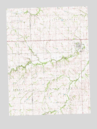
Palmyra, NE USGS Topographic Map
Click on map above to begin viewing in our Map Viewer.

This topographic map contains these locations and features:
Feature Name Type Latitude Longitude GNIS ID View Map
Clearidge Airport (historical)AirportN40.7097°W96.4770°837493View Map
Farmers Cooperative Company ElevatorLocaleN40.7044°W96.3875°1884346View Map
Mueller DamDamN40.6444°W96.4705°1770100View Map
Mueller ReservoirReservoirN40.6439°W96.4712°1770101View Map
North Palmyra Election PrecinctCivilN40.7405°W96.4064°1929107View Map
PalmyraLocaleN40.7028°W96.3881°1884347View Map
PalmyraPopulated PlaceN40.7044°W96.3875°831960View Map
Palmyra Election Precinct (historical)CivilN40.6942°W96.4139°1929131View Map
Palmyra Fire and RescueBuildingN40.7044°W96.3894°2553380View Map
Palmyra Junior-Senior High SchoolSchoolN40.7039°W96.3942°1884349View Map
Palmyra Memorial LibraryBuildingN40.7044°W96.3875°1884348View Map
Palmyra Post OfficePost OfficeN40.7029°W96.3896°1884345View Map
Palmyra RV CampLocaleN40.7044°W96.3875°1884344View Map
Rosewood CemeteryCemeteryN40.7125°W96.3981°832724View Map
Saint Leo Catholic ChurchChurchN40.7044°W96.3875°1884343View Map
Saint Leos CemeteryCemeteryN40.7111°W96.4000°832962View Map
South Palmyra Election PrecinctCivilN40.6535°W96.4067°1929294View Map
Township of North PalmyraCivilN40.7389°W96.4003°1884371View Map
Township of South PalmyraCivilN40.6528°W96.4058°1884372View Map
Triple Creek State Wildlife Management AreaParkN40.6639°W96.4045°1884235View Map
Village of PalmyraCivilN40.7057°W96.3921°2399615View Map

Note: Coordinates in the location and feature list above are referenced to NAD83 datum.


Copyright (C) 2008-2024 Ryan Niemi / Sunset Dynamics ... All Rights Reserved