TopoQuest Logo
Do you find TopoQuest useful?
Help keep TopoQuest running and adding new maps/features by donating!
Bitcoin:  19c7KJd3qBynnjoSw5npx9KScwjBe4ifkT
Litecoin:  LXs6TkuXGGXo1vDsWCkWVdjQX94eUKd6ui
Home View Maps Find Maps Find Places Resources & Links


Pine Prairie, Louisiana Topographic Map

USGS Map Title: Pine Prairie, LA
USGS Map MRC: 30092G4
DRG (GeoTIFF) Download: o30092g4.tif


Neighboring USGS Topographic Map Quads:


  Glenmora, LA  
30092H5
 

  Cocodrie Lake, LA  
30092H4
 

  Lone Pine, LA  
30092H3
 

  Beaver, LA  
30092G5
 

  Pine Prairie, LA  
30092G4
 

  Saint Landry, LA  
30092G3
 

  Bond, LA  
30092F5
 

  Mamou, LA  
30092F4
 

  Ville Platte, LA  
30092F3


Map MRC Location:

N31°
W93°
N31°
W92°
H8 H7 H6 H5 H4 H3 H2 H1
G8 G7 G6 G5 G4 G3 G2 G1
F8 F7 F6 F5 F4 F3 F2 F1
E8 E7 E6 E5 E4 E3 E2 E1
D8 D7 D6 D5 D4 D3 D2 D1
C8 C7 C6 C5 C4 C3 C2 C1
B8 B7 B6 B5 B4 B3 B2 B1
A8 A7 A6 A5 A4 A3 A2 A1
N30°
W93°
N30°
W92°

Pine Prairie, LA USGS 1:24K Topographic Map Preview:
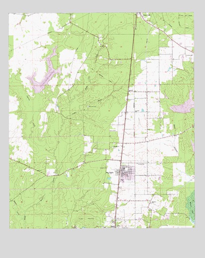
Pine Prairie, LA USGS Topographic Map
Click on map above to begin viewing in our Map Viewer.

This topographic map contains these locations and features:
Feature Name Type Latitude Longitude GNIS ID View Map
Ardoin CemeteryCemeteryN30.7505°W92.4240°542109View Map
Bayou NezpiqueStreamN30.7688°W92.3790°553499View Map
BealePopulated PlaceN30.8294°W92.4196°549415View Map
Beaver CreekStreamN30.7563°W92.4907°532861View Map
Campbell CemeteryCemeteryN30.7852°W92.4337°533665View Map
Campbell CemeteryCemeteryN30.8182°W92.4143°533666View Map
Carps BayouStreamN30.8121°W92.4629°533777View Map
Cedar Grove CemeteryCemeteryN30.8210°W92.4465°533836View Map
Church of ChristChurchN30.8747°W92.4116°2601665View Map
Crooked Creek ReservoirReservoirN30.8406°W92.4705°556751View Map
Cypress CreekStreamN30.7958°W92.4687°534366View Map
Dehany CemeteryCemeteryN30.8071°W92.4279°534475View Map
EastonPopulated PlaceN30.7513°W92.4287°543160View Map
Evangeline Parish Library Pine Prairie BranchBuildingN30.7830°W92.4242°2603061View Map
Evangeline Parish Library Turkey Creek BranchBuildingN30.8729°W92.4132°2603062View Map
Evangeline Parish Ward 5 Fire Protection DistrictBuildingN30.8745°W92.4151°2691742View Map
First Baptist ChurchChurchN30.7827°W92.4272°2601754View Map
Fontenot CemeteryCemeteryN30.7649°W92.4048°535023View Map
Friendship Baptist ChurchChurchN30.7971°W92.4282°554485View Map
Johnson CemeteryCemeteryN30.8505°W92.3801°536085View Map
Parish Governing Authority District 4CivilN30.8441°W92.4838°1930010View Map
Pentecost ChurchChurchN30.8299°W92.4185°538060View Map
Pine PrairiePopulated PlaceN30.7838°W92.4254°538191View Map
Pine Prairie Elementary SchoolSchoolN30.7849°W92.4229°545716View Map
Pine Prairie High SchoolSchoolN30.7848°W92.4230°545717View Map
Pine Prairie Police DepartmentBuildingN30.7783°W92.4227°2755250View Map
Pine Prairie Post OfficePost OfficeN30.7813°W92.4231°1630296View Map
Pine Prarie Wastewater Treatment PlantLocaleN30.7695°W92.4264°2603492View Map
Prairie Manor Nursing HomeBuildingN30.7772°W92.4232°2601103View Map
Saint Peters Catholic ChurchChurchN30.7818°W92.4233°2602756View Map
Saint Peters CemeteryCemeteryN30.7885°W92.4132°539054View Map
Trinity Baptist ChurchChurchN30.8727°W92.4093°545726View Map
Upper Bayou Nezpique Number Seven DamDamN30.7969°W92.3751°556752View Map
Upper Bayou Nezpique Number Six DamDamN30.8169°W92.3851°556753View Map
Upper Bayou Nezpique Number Three DamDamN30.8285°W92.4801°556750View Map
Village of Pine PrairieCivilN30.7818°W92.4224°2407521View Map
Village of Turkey CreekCivilN30.8732°W92.4170°2407563View Map
Ward FourCivilN30.8030°W92.4576°545024View Map

Note: Coordinates in the location and feature list above are referenced to NAD83 datum.


Copyright (C) 2008-2024 Ryan Niemi / Sunset Dynamics ... All Rights Reserved