TopoQuest Logo
Do you find TopoQuest useful?
Help keep TopoQuest running and adding new maps/features by donating!
Bitcoin:  19c7KJd3qBynnjoSw5npx9KScwjBe4ifkT
Litecoin:  LXs6TkuXGGXo1vDsWCkWVdjQX94eUKd6ui
Home View Maps Find Maps Find Places Resources & Links


Rockdale, Wisconsin Topographic Map

USGS Map Title: Rockdale, WI
USGS Map MRC: 42089H1
DRG (GeoTIFF) Download: o42089h1.tif


Neighboring USGS Topographic Map Quads:


  Cottage Grove, WI  
43089A2
 

  Deerfield, WI  
43089A1
 

  Lake Mills, WI  
43088A8
 

  Stoughton, WI  
42089H2
 

  Rockdale, WI  
42089H1
 

  Busseyville, WI  
42088H8
 

  Cooksville, WI  
42089G2
 

  Edgerton, WI  
42089G1
 

  Milton, WI  
42088G8


Map MRC Location:

N43°
W90°
N43°
W89°
H8 H7 H6 H5 H4 H3 H2 H1
G8 G7 G6 G5 G4 G3 G2 G1
F8 F7 F6 F5 F4 F3 F2 F1
E8 E7 E6 E5 E4 E3 E2 E1
D8 D7 D6 D5 D4 D3 D2 D1
C8 C7 C6 C5 C4 C3 C2 C1
B8 B7 B6 B5 B4 B3 B2 B1
A8 A7 A6 A5 A4 A3 A2 A1
N42°
W90°
N42°
W89°

Rockdale, WI USGS 1:24K Topographic Map Preview:
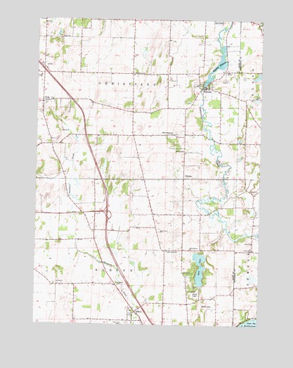
Rockdale, WI USGS Topographic Map
Click on map above to begin viewing in our Map Viewer.

This topographic map contains these locations and features:
Feature Name Type Latitude Longitude GNIS ID View Map
AlbionPopulated PlaceN42.8794°W89.0698°1560730View Map
Albion Prairie CemeteryCemeteryN42.9132°W89.0563°1560731View Map
Albion Prairie ChurchChurchN42.9061°W89.0387°1560732View Map
Albion Prairie SchoolSchoolN42.9053°W89.0518°1560733View Map
Busseyville SchoolSchoolN42.9056°W89.0043°1562464View Map
East Koshkonkong ChurchChurchN42.9531°W89.0487°1564339View Map
East Koshkonong CemeteryCemeteryN42.9535°W89.0479°2781252View Map
Evergreen CemeteryCemeteryN42.8920°W89.0789°1564741View Map
Hickory Hill Girl Scout CampLocaleN42.8956°W89.0384°1566358View Map
HillsidePopulated PlaceN42.9347°W89.0429°1566452View Map
Hillside SchoolSchoolN42.9461°W89.0429°1566467View Map
Kaupanger-Ramsey QuarryMineN42.9275°W89.1197°2633850View Map
Pioneer Norwegian CemeteryCemeteryN42.9311°W89.0430°2781289View Map
Rice LakeLakeN42.8983°W89.0329°1572254View Map
RockdalePopulated PlaceN42.9719°W89.0309°1572479View Map
Rockdale AirportAirportN42.9706°W89.0294°2717235View Map
Rockdale DamDamN42.9728°W89.0323°1792140View Map
Rockdale Lutheran Church CemeteryCemeteryN42.9735°W89.0373°2781291View Map
Rockdale MillpondReservoirN42.9728°W89.0323°1572480View Map
Rockdale Millpond 134ReservoirN42.9804°W89.0259°1792141View Map
RockGen Energy CenterBuildingN42.9769°W89.0489°2392418View Map
Smithback SchoolSchoolN42.9781°W89.0709°1574323View Map
Sweet CemeteryCemeteryN42.8887°W89.0392°1575179View Map
Sweet LakeSwampN42.8875°W89.0351°1575182View Map
Town of AlbionCivilN42.8915°W89.0728°1582668View Map
Town of ChristianaCivilN42.9776°W89.0739°1582959View Map
Turtle LakeSwampN42.8828°W89.0323°1575743View Map
UticaPopulated PlaceN42.9656°W89.1221°1576007View Map
Village of RockdaleCivilN42.9717°W89.0318°1584052View Map

Note: Coordinates in the location and feature list above are referenced to NAD83 datum.


Copyright (C) 2008-2024 Ryan Niemi / Sunset Dynamics ... All Rights Reserved