TopoQuest Logo
Do you find TopoQuest useful?
Help keep TopoQuest running and adding new maps/features by donating!
Bitcoin:  19c7KJd3qBynnjoSw5npx9KScwjBe4ifkT
Litecoin:  LXs6TkuXGGXo1vDsWCkWVdjQX94eUKd6ui
Home View Maps Find Maps Find Places Resources & Links


Cambridge, Missouri Topographic Map

USGS Map Title: Cambridge, MO
USGS Map MRC: 39092C8
DRG (GeoTIFF) Download: o39092c8.tif


Neighboring USGS Topographic Map Quads:


  Brunswick East, MO  
39093D1
 

  Keytesville, MO  
39092D8
 

  Salisbury, MO  
39092D7
 

  New Frankfort, MO  
39093C1
 

  Cambridge, MO  
39092C8
 

  Forest Green, MO  
39092C7
 

  Slater, MO  
39093B1
 

  Saline City, MO  
39092B8
 

  Glasgow, MO  
39092B7


Map MRC Location:

N40°
W93°
N40°
W92°
H8 H7 H6 H5 H4 H3 H2 H1
G8 G7 G6 G5 G4 G3 G2 G1
F8 F7 F6 F5 F4 F3 F2 F1
E8 E7 E6 E5 E4 E3 E2 E1
D8 D7 D6 D5 D4 D3 D2 D1
C8 C7 C6 C5 C4 C3 C2 C1
B8 B7 B6 B5 B4 B3 B2 B1
A8 A7 A6 A5 A4 A3 A2 A1
N39°
W93°
N39°
W92°

Cambridge, MO USGS 1:24K Topographic Map Preview:
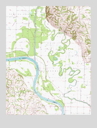
Cambridge, MO USGS Topographic Map
Click on map above to begin viewing in our Map Viewer.

This topographic map contains these locations and features:
Feature Name Type Latitude Longitude GNIS ID View Map
AholtPopulated PlaceN39.2645°W92.9049°740616View Map
Asbury CemeteryCemeteryN39.3574°W92.8976°2681413View Map
Asbury ChurchChurchN39.3570°W92.8974°713415View Map
Bear CreekStreamN39.2751°W92.9576°713804View Map
Big CutoffBendN39.3147°W92.9280°714164View Map
Brown CemeteryCemeteryN39.3700°W92.9707°714769View Map
Buck CreekStreamN39.2872°W92.9602°714960View Map
C and S LakeReservoirN39.2892°W92.9901°761756View Map
C and S Lake DamDamN39.2884°W92.9902°761755View Map
CambridgePopulated PlaceN39.2578°W92.9488°715226View Map
Cambridge CemeteryCemeteryN39.2525°W92.9599°715227View Map
CazzellPopulated PlaceN39.3070°W92.9421°740729View Map
Chariton RiverStreamN39.3128°W92.9582°455352View Map
Chariton River Main Stem LeveeLeveeN39.2642°W92.9172°2109551View Map
Cott LakeReservoirN39.2596°W92.9883°762260View Map
Cott Lake DamDamN39.2600°W92.9885°762259View Map
Elm Ridge ChurchChurchN39.3614°W92.9291°717530View Map
Gilliam BendBendN39.2683°W92.9419°2109553View Map
Gillis Chapel School (historical)SchoolN39.2775°W92.9191°734094View Map
Good Hope CemeteryCemeteryN39.2806°W92.9971°718552View Map
Hayes CutoffBendN39.3275°W92.9202°719258View Map
Henning CemeteryCemeteryN39.3550°W92.9744°719382View Map
Hill School (historical)SchoolN39.3611°W92.9291°734093View Map
Hurt School (historical)SchoolN39.3678°W92.8916°734092View Map
Immanuel ChurchChurchN39.3625°W92.9896°720089View Map
Kottman LakeReservoirN39.3617°W92.8835°761753View Map
Kottman Lake DamDamN39.3617°W92.8835°761752View Map
Little Missouri BendBendN39.3083°W92.9547°2109552View Map
Namrash (historical)Populated PlaceN39.3264°W92.9949°740316View Map
Palmer CreekStreamN39.3164°W92.9682°723976View Map
Porter Chapel CemeteryCemeteryN39.3461°W92.8921°724763View Map
Richardson School (historical)SchoolN39.3164°W92.9494°734091View Map
Riverside School (historical)SchoolN39.3267°W92.9938°734090View Map
RockfordPopulated PlaceN39.3464°W92.9144°741208View Map
Salem SchoolSchoolN39.3150°W92.8755°735835View Map
Shulte CemeteryCemeteryN39.3725°W92.9582°726423View Map
Smith LakeLakeN39.3239°W92.9241°726623View Map
Summers LakeReservoirN39.2525°W92.9938°761758View Map
Summers Lake DamDamN39.2534°W92.9935°761757View Map
Township of CharitonCivilN39.2955°W92.8823°766459View Map
Township of Missouri (historical)CivilN39.3328°W92.9763°766465View Map
Vance SchoolSchoolN39.2839°W92.8810°728131View Map
Whiteside LakeLakeN39.3596°W92.9629°728791View Map
Wilhoite BendBendN39.2553°W92.9153°2109555View Map
Young CreekStreamN39.3434°W92.9169°729209View Map

Note: Coordinates in the location and feature list above are referenced to NAD83 datum.


Copyright (C) 2008-2024 Ryan Niemi / Sunset Dynamics ... All Rights Reserved