TopoQuest Logo
Do you find TopoQuest useful?
Help keep TopoQuest running and adding new maps/features by donating!
Bitcoin:  19c7KJd3qBynnjoSw5npx9KScwjBe4ifkT
Litecoin:  LXs6TkuXGGXo1vDsWCkWVdjQX94eUKd6ui
Home View Maps Find Maps Find Places Resources & Links


Mount Olive, North Carolina Topographic Map

USGS Map Title: Mount Olive, NC
USGS Map MRC: 35078B1
DRG (GeoTIFF) Download: o35078b1.tif


Neighboring USGS Topographic Map Quads:


  Grantham, NC  
35078C2
 

  Southwest Goldsboro, NC  
35078C1
 

  Southeast Goldsboro, NC  
35077C8
 

  Dobbersville, NC  
35078B2
 

  Mount Olive, NC  
35078B1
 

  Williams, NC  
35077B8
 

  Faison, NC  
35078A2
 

  Warsaw North, NC  
35078A1
 

  Summerlins Crossroads, NC  
35077A8


Map MRC Location:

N36°
W79°
N36°
W78°
H8 H7 H6 H5 H4 H3 H2 H1
G8 G7 G6 G5 G4 G3 G2 G1
F8 F7 F6 F5 F4 F3 F2 F1
E8 E7 E6 E5 E4 E3 E2 E1
D8 D7 D6 D5 D4 D3 D2 D1
C8 C7 C6 C5 C4 C3 C2 C1
B8 B7 B6 B5 B4 B3 B2 B1
A8 A7 A6 A5 A4 A3 A2 A1
N35°
W79°
N35°
W78°

Mount Olive, NC USGS 1:24K Topographic Map Preview:
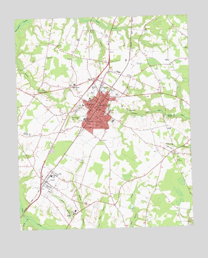
Mount Olive, NC USGS Topographic Map
Click on map above to begin viewing in our Map Viewer.

This topographic map contains these locations and features:
Feature Name Type Latitude Longitude GNIS ID View Map
Baker ChurchChurchN35.2343°W78.0947°980446View Map
Banisters ChapelChurchN35.1849°W78.0650°980517View Map
CalypsoPopulated PlaceN35.1538°W78.1053°982470View Map
Calypso Post OfficePost OfficeN35.1542°W78.1058°2505342View Map
Calypso Volunteer Fire DepartmentBuildingN35.1531°W78.1054°2638184View Map
Calypso Water Treatment PlantLocaleN35.1517°W78.0979°2506338View Map
Carver Memorial ParkCemeteryN35.1902°W78.0800°982707View Map
Carver SchoolSchoolN35.1896°W78.0761°982709View Map
College PlazaLocaleN35.2021°W78.0650°1007885View Map
Duplin County Sheriff's OfficeBuildingN35.1537°W78.1045°2131064View Map
Emmanuel ChurchChurchN35.2174°W78.0578°984771View Map
Faison Police DepartmentBuildingN35.1537°W78.1045°2130848View Map
Faith TabernacleChurchN35.1885°W78.0639°984961View Map
Full Gospel TabernacleChurchN35.1838°W78.0139°985493View Map
Gospel Light ChurchChurchN35.1879°W78.0644°985857View Map
Grace ChurchChurchN35.2388°W78.0580°985887View Map
Hill ChapelChurchN35.1891°W78.0769°986795View Map
Holy TempleChurchN35.1574°W78.0961°986993View Map
Jones Grove ChurchChurchN35.2257°W78.0839°987752View Map
Lee BranchStreamN35.2479°W78.0725°988287View Map
Maplewood CemeteryCemeteryN35.1943°W78.0594°989322View Map
Mount Gilead ChurchChurchN35.1771°W78.0653°990382View Map
Mount OlivePopulated PlaceN35.1966°W78.0664°990457View Map
Mount Olive CollegeSchoolN35.2088°W78.0697°990490View Map
Mount Olive College - Communications BuildingSchoolN35.2078°W78.0689°2505243View Map
Mount Olive College - George and Annie Dail Kornegay ArenaParkN35.2063°W78.0713°2505982View Map
Mount Olive College - Grantham HallSchoolN35.2053°W78.0691°2505244View Map
Mount Olive College - Henderson BuildingSchoolN35.2087°W78.0696°2505245View Map
Mount Olive College - Laughinghouse HallSchoolN35.2066°W78.0682°2505246View Map
Mount Olive College - Lois K Murphy Regional CenterSchoolN35.2073°W78.0712°2505247View Map
Mount Olive College - Moye LibraryBuildingN35.2081°W78.0693°2505953View Map
Mount Olive College - Poole Administration BuildingSchoolN35.2078°W78.0710°2505248View Map
Mount Olive College - Pope Wellness CenterSchoolN35.2058°W78.0719°2505249View Map
Mount Olive College - Rodgers ChapelChurchN35.2073°W78.0695°2505702View Map
Mount Olive College - W Burkette and Rose M Raper HallSchoolN35.2076°W78.0680°2505250View Map
Mount Olive Fire DepartmentBuildingN35.1993°W78.0644°2638847View Map
Mount Olive Junior High SchoolSchoolN35.2013°W78.0725°1006966View Map
Mount Olive Municipal AirportAirportN35.2221°W78.0389°997898View Map
Mount Olive Police DepartmentBuildingN35.1957°W78.0653°2130905View Map
Mount Olive Post OfficePost OfficeN35.2031°W78.0661°2773869View Map
Mount Zion ChurchChurchN35.1571°W78.0997°990635View Map
North Duplin Elementary SchoolSchoolN35.1367°W78.0838°1001133View Map
North Duplin SchoolSchoolN35.1341°W78.0853°991217View Map
Northeast ChapelChurchN35.1927°W78.0592°991286View Map
Northeast ChurchChurchN35.2146°W78.0422°991287View Map
Panther BranchStreamN35.1382°W78.1230°1025599View Map
Payne TempleChurchN35.1874°W78.0742°991959View Map
Price CemeteryCemeteryN35.2102°W78.0867°992802View Map
Reedy BranchStreamN35.1318°W78.1180°993180View Map
Rones Methodist ChapelChurchN35.1682°W78.0117°1008243View Map
Saint James ChurchChurchN35.1918°W78.0744°993905View Map
Saint Lukes ChurchChurchN35.1638°W78.0103°993988View Map
Saint Marks ChurchChurchN35.1863°W78.0680°994012View Map
Saint Marys ChurchChurchN35.1974°W78.0708°994029View Map
Salem ChurchChurchN35.2027°W78.0544°994164View Map
Shady Grove ChurchChurchN35.2271°W78.1022°994543View Map
Sheriff Department Sub StationBuildingN35.1537°W78.1049°2131066View Map
Southern Mobile Home ParkPopulated PlaceN35.1822°W78.0817°2505657View Map
Stanley ChapelChurchN35.2238°W78.0142°995411View Map
The Village Shopping CenterLocaleN35.2118°W78.0617°1006965View Map
Thunder Swamp ChurchChurchN35.2066°W78.1086°996090View Map
Town of CalypsoCivilN35.1548°W78.1044°2405366View Map
Town of Mount OliveCivilN35.1981°W78.0683°2406209View Map
Union ChurchChurchN35.1646°W78.0103°996451View Map
University of Mount OliveSchoolN35.2065°W78.0712°990491View Map
Wayne County Emergency Medical Services Station 9BuildingN35.2014°W78.0623°2720356View Map
WDJS-AM (Mount Olive)TowerN35.2046°W78.0514°1018411View Map
Wilson CemeteryCemeteryN35.1393°W78.0764°997436View Map
Winn ChapelChurchN35.1893°W78.0739°997493View Map

Note: Coordinates in the location and feature list above are referenced to NAD83 datum.


Copyright (C) 2008-2024 Ryan Niemi / Sunset Dynamics ... All Rights Reserved