TopoQuest Logo
Do you find TopoQuest useful?
Help keep TopoQuest running and adding new maps/features by donating!
Bitcoin:  19c7KJd3qBynnjoSw5npx9KScwjBe4ifkT
Litecoin:  LXs6TkuXGGXo1vDsWCkWVdjQX94eUKd6ui
Home View Maps Find Maps Find Places Resources & Links


Williams, North Carolina Topographic Map

USGS Map Title: Williams, NC
USGS Map MRC: 35077B8
DRG (GeoTIFF) Download: o35077b8.tif


Neighboring USGS Topographic Map Quads:


  Southwest Goldsboro, NC  
35078C1
 

  Southeast Goldsboro, NC  
35077C8
 

  La Grange, NC  
35077C7
 

  Mount Olive, NC  
35078B1
 

  Williams, NC  
35077B8
 

  Seven Springs, NC  
35077B7
 

  Warsaw North, NC  
35078A1
 

  Summerlins Crossroads, NC  
35077A8
 

  Albertson, NC  
35077A7


Map MRC Location:

N36°
W78°
N36°
W77°
H8 H7 H6 H5 H4 H3 H2 H1
G8 G7 G6 G5 G4 G3 G2 G1
F8 F7 F6 F5 F4 F3 F2 F1
E8 E7 E6 E5 E4 E3 E2 E1
D8 D7 D6 D5 D4 D3 D2 D1
C8 C7 C6 C5 C4 C3 C2 C1
B8 B7 B6 B5 B4 B3 B2 B1
A8 A7 A6 A5 A4 A3 A2 A1
N35°
W78°
N35°
W77°

Williams, NC USGS 1:24K Topographic Map Preview:
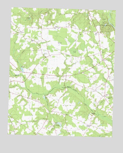
Williams, NC USGS Topographic Map
Click on map above to begin viewing in our Map Viewer.

This topographic map contains these locations and features:
Feature Name Type Latitude Longitude GNIS ID View Map
Bennetts BridgeBridgeN35.1485°W77.8972°981001View Map
Best ChapelChurchN35.2316°W77.9422°981057View Map
Blizzards CrossroadsPopulated PlaceN35.1366°W77.9016°1019218View Map
Briar BedSwampN35.2207°W77.9697°981857View Map
Camp Eagles WestLocaleN35.2396°W77.9780°1024578View Map
Camp JubileeLocaleN35.2254°W77.9172°1024579View Map
Cliffs of the Neuse State ParkParkN35.2388°W77.8841°1023912View Map
Deavers PondReservoirN35.1624°W77.9569°998467View Map
Devils WoodyardSwampN35.2052°W77.9583°984155View Map
Garners ChapelChurchN35.1466°W77.9311°985576View Map
GradysPopulated PlaceN35.1657°W77.8853°985905View Map
Grants ChapelChurchN35.1877°W77.9153°985927View Map
Green BranchStreamN35.1827°W77.9333°1024003View Map
Hines CrossroadsPopulated PlaceN35.2010°W77.8889°1020781View Map
Holly Lake DamDamN35.1385°W77.9397°998428View Map
HopewellPopulated PlaceN35.2263°W77.9878°1006245View Map
Horsepen BranchStreamN35.1982°W77.9911°1024044View Map
Horsepen PocosinSwampN35.2163°W77.9414°987136View Map
Indian SpringsPopulated PlaceN35.2310°W77.9478°987368View Map
Indian Springs Volunteer Fire DepartmentBuildingN35.2392°W77.9613°2639231View Map
Jones CemeteryCemeteryN35.1615°W77.9761°987720View Map
Jones ChapelChurchN35.1377°W77.9472°987734View Map
Jumping Juniper BranchStreamN35.1929°W77.9475°1024067View Map
Jumping Run BranchStreamN35.1718°W77.9386°1024568View Map
Juniper PondSwampN35.2085°W77.9232°987854View Map
Ladds BranchStreamN35.1366°W77.9422°1024076View Map
Lake Genele DamDamN35.1652°W77.9564°998468View Map
Lewis BranchStreamN35.1838°W77.9839°988375View Map
Pineview CemeteryCemeteryN35.2078°W77.8906°1024218View Map
Polly Run CreekStreamN35.1577°W77.9533°992652View Map
Powell RunStreamN35.2446°W77.9100°1024567View Map
PricetownPopulated PlaceN35.1710°W77.8966°1022079View Map
Pricetown Volunteer Fire DepartmentBuildingN35.1698°W77.8937°2639564View Map
Rattlesnake BranchStreamN35.1702°W77.9783°993049View Map
Run BranchStreamN35.1821°W77.9386°1024282View Map
Shines BridgeBridgeN35.1727°W77.9325°994723View Map
Smiths ChapelChurchN35.2024°W77.9561°995000View Map
Spring Creek SchoolSchoolN35.2268°W77.8975°1024580View Map
Tommy Reed CreekStreamN35.2479°W77.9572°1024354View Map
Township of Indian SpringsCivilN35.2247°W77.9372°1027315View Map
Township of WolfscrapeCivilN35.1272°W77.9831°1026651View Map
Tuscarora CampLocaleN35.2407°W77.9769°996371View Map
Wayne ChapelChurchN35.2188°W77.9742°996890View Map
Whitfields PondReservoirN35.1366°W77.9383°998427View Map
WilliamsPopulated PlaceN35.1860°W77.9739°997357View Map
Williams MillpondReservoirN35.1892°W77.9844°997387View Map
Williams Millpond DamDamN35.1871°W77.9842°998507View Map
Wolfscrape BranchStreamN35.1410°W77.9500°1024412View Map
Zion ChurchChurchN35.1707°W77.8966°997762View Map

Note: Coordinates in the location and feature list above are referenced to NAD83 datum.


Copyright (C) 2008-2024 Ryan Niemi / Sunset Dynamics ... All Rights Reserved