TopoQuest Logo
Do you find TopoQuest useful?
Help keep TopoQuest running and adding new maps/features by donating!
Bitcoin:  19c7KJd3qBynnjoSw5npx9KScwjBe4ifkT
Litecoin:  LXs6TkuXGGXo1vDsWCkWVdjQX94eUKd6ui
Home View Maps Find Maps Find Places Resources & Links


Summerlins Crossroads, North Carolina Topographic Map

USGS Map Title: Summerlins Crossroads, NC
USGS Map MRC: 35077A8
DRG (GeoTIFF) Download: o35077a8.tif


Neighboring USGS Topographic Map Quads:


  Mount Olive, NC  
35078B1
 

  Williams, NC  
35077B8
 

  Seven Springs, NC  
35077B7
 

  Warsaw North, NC  
35078A1
 

  Summerlins Crossroads, NC  
35077A8
 

  Albertson, NC  
35077A7
 

  Warsaw South, NC  
34078H1
 

  Kenansville, NC  
34077H8
 

  Beulaville, NC  
34077H7


Map MRC Location:

N36°
W78°
N36°
W77°
H8 H7 H6 H5 H4 H3 H2 H1
G8 G7 G6 G5 G4 G3 G2 G1
F8 F7 F6 F5 F4 F3 F2 F1
E8 E7 E6 E5 E4 E3 E2 E1
D8 D7 D6 D5 D4 D3 D2 D1
C8 C7 C6 C5 C4 C3 C2 C1
B8 B7 B6 B5 B4 B3 B2 B1
A8 A7 A6 A5 A4 A3 A2 A1
N35°
W78°
N35°
W77°

Summerlins Crossroads, NC USGS 1:24K Topographic Map Preview:
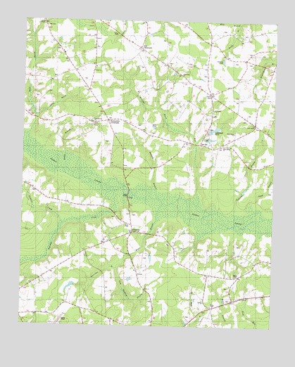
Summerlins Crossroads, NC USGS Topographic Map
Click on map above to begin viewing in our Map Viewer.

This topographic map contains these locations and features:
Feature Name Type Latitude Longitude GNIS ID View Map
Alum Springs ChurchChurchN35.0743°W77.9003°980158View Map
Beaverdam BranchStreamN35.0235°W77.9525°1023811View Map
Bethel Methodist ChurchChurchN35.1043°W77.9650°1008234View Map
Branchs Store Post Office (historical)Post OfficeN35.1207°W77.8972°1008040View Map
Brocks ChapelChurchN35.1238°W77.9905°981959View Map
Bullard BranchStreamN35.0588°W77.9347°982216View Map
Calvary ChurchChurchN35.0104°W77.9086°1007487View Map
Dails PondReservoirN35.0813°W77.9346°983914View Map
Duplin County AirportAirportN35.0009°W77.9833°1025865View Map
Giffords BranchStreamN35.0443°W77.8933°1023989View Map
Grape BranchStreamN35.0513°W77.8833°985931View Map
Grayfield Mobile Home ParkPopulated PlaceN35.0217°W77.9916°2505590View Map
Gum Pudding BranchStreamN35.0235°W77.9522°986228View Map
Halls MarshStreamN35.0832°W77.9942°986324View Map
Herrings Marsh RunStreamN35.0504°W77.9150°1024032View Map
Hills CrossroadsPopulated PlaceN35.1141°W77.9417°986825View Map
Kinsey Jones PondReservoirN35.0974°W77.9336°988013View Map
Kinsey Jones PondLakeN35.0963°W77.9389°1008036View Map
Lightwood PondLakeN35.0807°W77.9046°988479View Map
Little MarshStreamN35.0857°W77.9936°988702View Map
Long BranchStreamN35.0896°W77.9336°988891View Map
Long Ridge ChurchChurchN35.1032°W77.9214°989002View Map
Maple BranchStreamN35.0418°W77.9297°1024128View Map
McGowen Post Office (historical)Post OfficeN35.0324°W77.9233°1008038View Map
Nahunga CreekStreamN35.0554°W77.9539°990839View Map
Oak Wolfe Fire DepartmentBuildingN35.1122°W77.9805°2638207View Map
Outlaws PondReservoirN35.1090°W77.9009°991734View Map
Pate CemeteryCemeteryN35.1227°W77.9883°991925View Map
Pearsall ChapelChurchN35.0207°W77.8925°991992View Map
Pearsall Post Office (historical)Post OfficeN35.0210°W77.8905°1008041View Map
Piney Green ChurchChurchN35.0793°W77.8861°1024581View Map
Red HillPopulated PlaceN35.0752°W77.9114°1024249View Map
Reedy BranchStreamN35.1243°W77.8933°1024252View Map
Rooty BranchStreamN35.0646°W77.9778°1024279View Map
Rooty Branch ChurchChurchN35.0838°W77.9639°993673View Map
Saint Stephen ChurchChurchN35.0888°W77.9055°994142View Map
Scotts StorePopulated PlaceN35.0949°W77.9064°994438View Map
Smith CemeteryCemeteryN35.0449°W77.9536°994944View Map
Smith ChapelChurchN35.0410°W77.9486°994955View Map
Snow Hill ChurchChurchN35.0818°W77.8847°995067View Map
Stewarts CreekStreamN35.0427°W77.9800°995504View Map
Summerlins CrossroadsPopulated PlaceN35.0843°W77.9575°1022836View Map
Sutton ChapelChurchN35.1196°W77.9536°1007486View Map
Township of GlissonCivilN35.0886°W77.8820°1026642View Map
Wards BridgeBridgeN35.0538°W77.9469°996785View Map
Welch BranchStreamN35.0004°W77.8936°996932View Map
Wesley Methodist ChurchChurchN35.0082°W77.9053°1008246View Map
Westbrook CrossroadsPopulated PlaceN35.0385°W77.9450°1005912View Map

Note: Coordinates in the location and feature list above are referenced to NAD83 datum.


Copyright (C) 2008-2024 Ryan Niemi / Sunset Dynamics ... All Rights Reserved