TopoQuest Logo
Do you find TopoQuest useful?
Help keep TopoQuest running and adding new maps/features by donating!
Bitcoin:  19c7KJd3qBynnjoSw5npx9KScwjBe4ifkT
Litecoin:  LXs6TkuXGGXo1vDsWCkWVdjQX94eUKd6ui
Home View Maps Find Maps Find Places Resources & Links


Coquille, Oregon Topographic Map

USGS Map Title: Coquille, OR
USGS Map MRC: 43124B2
DRG (GeoTIFF) Download: o43124b2.tif


Neighboring USGS Topographic Map Quads:


  Charleston, OR  
43124C3
 

  Coos Bay, OR  
43124C2
 

  Daniels Creek, OR  
43124C1
 

  Riverton, OR  
43124B3
 

  Coquille, OR  
43124B2
 

  McKinley, OR  
43124B1
 

  Bill Peak, OR  
43124A3
 

  Myrtle Point, OR  
43124A2
 

  Bridge, OR  
43124A1


Map MRC Location:

N44°
W125°
N44°
W124°
H8 H7 H6 H5 H4 H3 H2 H1
G8 G7 G6 G5 G4 G3 G2 G1
F8 F7 F6 F5 F4 F3 F2 F1
E8 E7 E6 E5 E4 E3 E2 E1
D8 D7 D6 D5 D4 D3 D2 D1
C8 C7 C6 C5 C4 C3 C2 C1
B8 B7 B6 B5 B4 B3 B2 B1
A8 A7 A6 A5 A4 A3 A2 A1
N43°
W125°
N43°
W124°

Coquille, OR USGS 1:24K Topographic Map Preview:
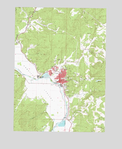
Coquille, OR USGS Topographic Map
Click on map above to begin viewing in our Map Viewer.

This topographic map contains these locations and features:
Feature Name Type Latitude Longitude GNIS ID View Map
5th Street ParkParkN43.1784°W124.1859°2058289View Map
A B Crossing (historical)LocaleN43.1526°W124.1790°1166260View Map
Anderson CreekStreamN43.1332°W124.1915°1132604View Map
Baisen (historical)LocaleN43.1915°W124.2246°1166262View Map
Beaver CreekStreamN43.2307°W124.2357°1117415View Map
Beaver Hill Junction (historical)LocaleN43.2126°W124.2434°1166263View Map
Benham AirportAirportN43.1551°W124.1724°2646007View Map
Budd CreekStreamN43.1901°W124.1901°1118253View Map
Budd MountainSummitN43.1976°W124.1873°1118254View Map
Calloway CreekStreamN43.1859°W124.1929°1118475View Map
Cedar PointPopulated PlaceN43.1796°W124.2134°1161307View Map
ChromeLocaleN43.2146°W124.2462°1118934View Map
City of CoquilleCivilN43.1801°W124.1841°2410226View Map
CoaledoPopulated PlaceN43.2323°W124.2332°1119057View Map
Coaledo Post Office (historical)Post OfficeN43.2323°W124.2332°1165068View Map
Coffee CreekStreamN43.2009°W124.1573°1119073View Map
Cold CreekStreamN43.2076°W124.1509°1119099View Map
Coos County CourthouseBuildingN43.1765°W124.1864°2661133View Map
Coos County JailBuildingN43.1761°W124.1864°2722754View Map
Coos County Public WorksBuildingN43.1853°W124.2028°2661523View Map
Coos County Sheriff's OfficeBuildingN43.1766°W124.1865°2737643View Map
Coquile MuseumBuildingN43.1754°W124.1898°2661460View Map
CoquillePopulated PlaceN43.1771°W124.1876°1119276View Map
Coquille Boat RampLocaleN43.1734°W124.1917°2058201View Map
Coquille City HallBuildingN43.1822°W124.1893°2661371View Map
Coquille DivisionCivilN43.1880°W124.2465°1937986View Map
Coquille Fire and RescueBuildingN43.1767°W124.1897°2576611View Map
Coquille Foursquare ChurchChurchN43.1883°W124.1975°2508096View Map
Coquille High SchoolSchoolN43.1859°W124.1943°2416172View Map
Coquille Municipal CourtBuildingN43.1821°W124.1893°2661373View Map
Coquille Police DepartmentBuildingN43.1822°W124.1893°2737754View Map
Coquille Post OfficePost OfficeN43.1751°W124.1911°1165087View Map
Coquille Public LibraryBuildingN43.1755°W124.1913°2661297View Map
Coquille Public WorksBuildingN43.1822°W124.1893°2661554View Map
Coquille Sewage Treatment PlantLocaleN43.1757°W124.1918°2660658View Map
Coquille Valley HospitalHospitalN43.1795°W124.1794°1119279View Map
Coquille Valley Intermediate SchoolSchoolN43.1847°W124.1876°1161660View Map
Coquille Water Treatment PlantLocaleN43.1765°W124.1392°2660767View Map
Crystal CreekStreamN43.1651°W124.1859°1132598View Map
Cunningham CreekStreamN43.1793°W124.2023°1161337View Map
Department of Motor Vehicles CoquilleBuildingN43.1742°W124.1971°2661339View Map
Dufoe CreekStreamN43.2326°W124.2304°1132141View Map
Dunham GulchValleyN43.2415°W124.2359°1132567View Map
Dutch John RavineValleyN43.1721°W124.1840°1120239View Map
Dye CreekStreamN43.2048°W124.1557°1120248View Map
Emmanuel Baptist Church of Coquille OregonChurchN43.1803°W124.1919°2508097View Map
Fairview Junction (historical)LocaleN43.1798°W124.2034°1166273View Map
Fall CreekStreamN43.1643°W124.1468°1120590View Map
Fat Elk CreekStreamN43.1787°W124.2287°1120641View Map
Fortier FieldParkN43.1871°W124.1840°1120895View Map
G H Chaney Logging Railroad Crossing (historical)LocaleN43.1362°W124.1801°1166274View Map
Garden GulchValleyN43.2387°W124.2359°1132597View Map
George ReservoirReservoirN43.1646°W124.1558°1132599View Map
Glen Aiken CreekStreamN43.1379°W124.1818°1121155View Map
Harlin CreekStreamN43.1346°W124.1721°1132600View Map
Hungry HollowValleyN43.2073°W124.1504°1122135View Map
Hungry MountainSummitN43.1924°W124.1293°1122136View Map
Independent Order of Odd Fellows CemeteryCemeteryN43.1895°W124.1945°1132606View Map
Jefferson School (historical)SchoolN43.1903°W124.1978°1122398View Map
Johnson (historical)LocaleN43.1396°W124.1796°1166667View Map
Johnson Log Storage and Sorting DamDamN43.1332°W124.1912°1131390View Map
Johnson Log Storage and Storing ReservoirReservoirN43.1332°W124.1912°1131389View Map
KSHR-AMTowerN43.1718°W124.1990°1131238View Map
Lincoln Elementary SchoolSchoolN43.1871°W124.1829°1123099View Map
Lions Club ParkParkN43.1865°W124.1923°2058290View Map
Masonic CemeteryCemeteryN43.1885°W124.1945°1154844View Map
Montgomerys CabinLocaleN43.2237°W124.1518°1124302View Map
Myers CreekStreamN43.1629°W124.1554°1124574View Map
Myrtle Crest Memorial GardensCemeteryN43.1601°W124.1773°1124579View Map
Noble HillSummitN43.2380°W124.1540°1124700View Map
North Fork Glen Aiken CreekStreamN43.1457°W124.1651°1132601View Map
OverlandLocaleN43.2454°W124.2240°1166690View Map
Overland MineMineN43.2493°W124.2434°1125071View Map
Penny Sturdivant ParkParkN43.1754°W124.1996°1127679View Map
Phil CreekStreamN43.2012°W124.2234°1132155View Map
Pulaski CreekStreamN43.1482°W124.2012°1125698View Map
Reservoir CreekStreamN43.1693°W124.2359°1132605View Map
Rink CreekStreamN43.1568°W124.1804°1126043View Map
Rink Creek DamDamN43.1765°W124.1395°1131388View Map
Rink Creek ReservoirReservoirN43.1769°W124.1360°1126044View Map
Sanford Heights ParkParkN43.1837°W124.2026°2058291View Map
Sanford Heights PlaygroundParkN43.1837°W124.2018°1126595View Map
Sawdust TheatreBuildingN43.1744°W124.1874°2661123View Map
Shuck MountainSummitN43.1294°W124.1374°1126935View Map
Sturdivant Park Boat RampLocaleN43.1747°W124.1988°2668252View Map
United Valley Christian AcademySchoolN43.1901°W124.1957°2416185View Map
Walker CreekStreamN43.1654°W124.1451°1128588View Map
Washington School (historical)SchoolN43.1761°W124.1819°1128699View Map
Yoakum (historical)LocaleN43.1984°W124.2346°1166285View Map

Note: Coordinates in the location and feature list above are referenced to NAD83 datum.


Copyright (C) 2008-2024 Ryan Niemi / Sunset Dynamics ... All Rights Reserved