TopoQuest Logo
Do you find TopoQuest useful?
Help keep TopoQuest running and adding new maps/features by donating!
Bitcoin:  19c7KJd3qBynnjoSw5npx9KScwjBe4ifkT
Litecoin:  LXs6TkuXGGXo1vDsWCkWVdjQX94eUKd6ui
Home View Maps Find Maps Find Places Resources & Links


Cora, Wyoming Topographic Map

USGS Map Title: Cora, WY
USGS Map MRC: 42109H8
DRG (GeoTIFF) Download: o42109h8.tif


Neighboring USGS Topographic Map Quads:


  Warren Bridge, WY  
43110A1
 

  New Fork Lakes, WY  
43109A8
 

  Fremont Lake North, WY  
43109A7
 

  Daniel Junction, WY  
42110H1
 

  Cora, WY  
42109H8
 

  Fremont Lake South, WY  
42109H7
 

  Daniel, WY  
42110G1
 

  Mount Airy, WY  
42109G8
 

  Pinedale, WY  
42109G7


Map MRC Location:

N43°
W110°
N43°
W109°
H8 H7 H6 H5 H4 H3 H2 H1
G8 G7 G6 G5 G4 G3 G2 G1
F8 F7 F6 F5 F4 F3 F2 F1
E8 E7 E6 E5 E4 E3 E2 E1
D8 D7 D6 D5 D4 D3 D2 D1
C8 C7 C6 C5 C4 C3 C2 C1
B8 B7 B6 B5 B4 B3 B2 B1
A8 A7 A6 A5 A4 A3 A2 A1
N42°
W110°
N42°
W109°

Cora, WY USGS 1:24K Topographic Map Preview:
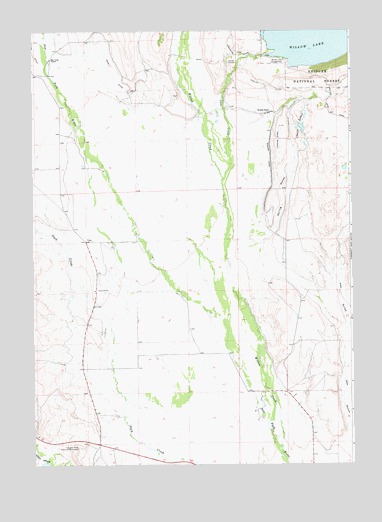
Cora, WY USGS Topographic Map
Click on map above to begin viewing in our Map Viewer.

This topographic map contains these locations and features:
Feature Name Type Latitude Longitude GNIS ID View Map
Bar Cross RanchLocaleN42.9922°W109.9929°1585105View Map
Binning DitchCanalN42.9638°W109.9060°1585547View Map
Binning RanchLocaleN42.9763°W109.9068°1585548View Map
Chain LakesLakeN42.9720°W109.8943°1586538View Map
CoraPopulated PlaceN42.9397°W109.9796°1597349View Map
Cora - Westfall CemeteryCemeteryN42.9523°W109.9861°2774432View Map
Cora Census Designated PlaceCensusN42.9577°W109.9916°2407659View Map
Cora PitMineN42.9444°W109.9861°1746429View Map
Cora Post OfficePost OfficeN42.9395°W109.9781°2767890View Map
F Bar Cross Seventy-six MineMineN42.9905°W109.9885°1746430View Map
Faler CreekStreamN42.8761°W109.9957°1596819View Map
Freds Hill PitMineN42.8939°W109.8928°1746431View Map
Graveyard PitMineN42.9517°W109.9861°1746432View Map
Hay GulchValleyN42.9049°W109.8757°1600247View Map
Highline DitchCanalN42.9847°W109.9063°1589555View Map
Indian GravesCemeteryN42.9911°W109.9227°1589898View Map
Jenkins DitchCanalN42.9941°W109.9996°1590074View Map
Lake CreekStreamN42.9569°W109.9249°1600785View Map
Noble PitMineN42.9661°W109.9875°1746433View Map
Rahm DitchCanalN42.9877°W109.9679°1602359View Map
Spring GulchValleyN42.9416°W109.9046°1594915View Map
Trappers Point Historical MonumentLocaleN42.8797°W109.9827°1595690View Map
Willow CreekStreamN42.8791°W109.9032°1604208View Map
Willow Lake CampgroundLocaleN42.9919°W109.9007°1596464View Map
Willow Lake DamDamN42.9916°W109.9090°1607830View Map
Wimple PitMineN42.9772°W109.9878°1746434View Map

Note: Coordinates in the location and feature list above are referenced to NAD83 datum.


Copyright (C) 2008-2024 Ryan Niemi / Sunset Dynamics ... All Rights Reserved