TopoQuest Logo
Do you find TopoQuest useful?
Help keep TopoQuest running and adding new maps/features by donating!
Bitcoin:  19c7KJd3qBynnjoSw5npx9KScwjBe4ifkT
Litecoin:  LXs6TkuXGGXo1vDsWCkWVdjQX94eUKd6ui
Home View Maps Find Maps Find Places Resources & Links


Fremont Lake North, Wyoming Topographic Map

USGS Map Title: Fremont Lake North, WY
USGS Map MRC: 43109A7
DRG (GeoTIFF) Download: o43109a7.tif


Neighboring USGS Topographic Map Quads:


  Kendall Mountain, WY  
43109B8
 

  Squaretop Mountain, WY  
43109B7
 

  Gannett Peak, WY  
43109B6
 

  New Fork Lakes, WY  
43109A8
 

  Fremont Lake North, WY  
43109A7
 

  Bridger Lakes, WY  
43109A6
 

  Cora, WY  
42109H8
 

  Fremont Lake South, WY  
42109H7
 

  Fayette Lake, WY  
42109H6


Map MRC Location:

N44°
W110°
N44°
W109°
H8 H7 H6 H5 H4 H3 H2 H1
G8 G7 G6 G5 G4 G3 G2 G1
F8 F7 F6 F5 F4 F3 F2 F1
E8 E7 E6 E5 E4 E3 E2 E1
D8 D7 D6 D5 D4 D3 D2 D1
C8 C7 C6 C5 C4 C3 C2 C1
B8 B7 B6 B5 B4 B3 B2 B1
A8 A7 A6 A5 A4 A3 A2 A1
N43°
W110°
N43°
W109°

Fremont Lake North, WY USGS 1:24K Topographic Map Preview:
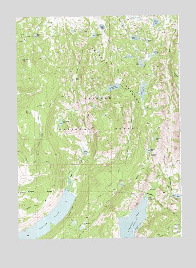
Fremont Lake North, WY USGS Topographic Map
Click on map above to begin viewing in our Map Viewer.

This topographic map contains these locations and features:
Feature Name Type Latitude Longitude GNIS ID View Map
Big Flattop MountainSummitN43.0638°W109.8715°1598145View Map
Big Rock ParkFlatN43.0986°W109.8500°2573556View Map
Bluff Creek TrailTrailN43.0552°W109.8577°1598272View Map
Bluff ParkFlatN43.0908°W109.8304°1598273View Map
Bluff Park CreekStreamN43.0724°W109.8246°1598274View Map
Borum LakeLakeN43.1212°W109.7679°1598309View Map
Bridger CreekStreamN43.0361°W109.7635°1598370View Map
Cliff LakeLakeN43.1168°W109.8317°1598806View Map
Crows Nest LookoutLocaleN43.0136°W109.7624°1604733View Map
Crows Nest LookoutLocaleN43.0466°W109.7729°1599058View Map
Cumberland CreekStreamN43.0930°W109.7596°1599073View Map
Elkhart ParkFlatN43.0041°W109.7546°1599596View Map
Faler CreekStreamN43.0233°W109.7765°1599657View Map
Fremont CreekStreamN43.0347°W109.7579°1599854View Map
Glimpse LakeLakeN43.0489°W109.7746°1599952View Map
Glimpse Lake TrailTrailN43.0236°W109.8032°1599953View Map
Gottfried LakeLakeN43.1107°W109.7747°1599990View Map
Heart LakeLakeN43.1123°W109.7844°1600274View Map
Indian ParkFlatN43.0663°W109.8582°1600502View Map
Lily Pond LakeLakeN43.0652°W109.8418°1600915View Map
Little Trapper LakeLakeN43.0726°W109.7773°1601053View Map
Long Lake TrailTrailN43.0288°W109.7682°1604732View Map
Lost Camp LakeLakeN43.1142°W109.8151°1601130View Map
Martin ParkFlatN43.1127°W109.8690°1601273View Map
Miller CreekStreamN43.0252°W109.7768°1601460View Map
Moosehead BayBayN43.0044°W109.7852°1601551View Map
Neil LakeLakeN43.1041°W109.7683°1601672View Map
Pine Creek Canyon TrailTrailN43.0891°W109.7799°1602154View Map
Pine MountainSummitN43.0758°W109.7979°1602166View Map
Prospector LakeLakeN43.0558°W109.7698°1602318View Map
Rainbow LakeLakeN43.1143°W109.8605°1602365View Map
Round LakeLakeN43.1190°W109.8089°1602637View Map
Section Corner LakeLakeN43.0847°W109.8010°1602791View Map
Section Corner Lake TrailTrailN43.0772°W109.8468°1602792View Map
Snake LakeLakeN43.0486°W109.8234°1603017View Map
Snake Lake TrailTrailN43.0430°W109.8288°1603018View Map
Spring Creek ParkFlatN43.0077°W109.8249°1603277View Map
Trail LakeLakeN43.0980°W109.7799°1603741View Map
Trails End CampgroundLocaleN43.0122°W109.7524°1608749View Map
Trapper CreekStreamN43.0449°W109.8249°1603750View Map
Trapper LakeLakeN43.0826°W109.7784°1603752View Map
Trapper Lake Stock TrailTrailN43.0419°W109.7946°1603753View Map
Upper Fremont Lake CampgroundLocaleN43.0224°W109.7754°1603872View Map
Willow Creek LookoutLocaleN43.0999°W109.8699°1604214View Map
Willow LakeLakeN43.0037°W109.8719°1604220View Map
Willow Lake TrailTrailN43.0383°W109.8457°1604221View Map

Note: Coordinates in the location and feature list above are referenced to NAD83 datum.


Copyright (C) 2008-2024 Ryan Niemi / Sunset Dynamics ... All Rights Reserved