TopoQuest Logo
Do you find TopoQuest useful?
Help keep TopoQuest running and adding new maps/features by donating!
Bitcoin:  19c7KJd3qBynnjoSw5npx9KScwjBe4ifkT
Litecoin:  LXs6TkuXGGXo1vDsWCkWVdjQX94eUKd6ui
Home View Maps Find Maps Find Places Resources & Links


Corbet, Texas Topographic Map

USGS Map Title: Corbet, TX
USGS Map MRC: 32096A5
DRG (GeoTIFF) Download: o32096a5.tif


Neighboring USGS Topographic Map Quads:


  Cryer Creek, TX  
32096B6
 

  Emhouse, TX  
32096B5
 

  Chatfield, TX  
32096B4
 

  Blooming Grove, TX  
32096A6
 

  Corbet, TX  
32096A5
 

  Corsicana, TX  
32096A4
 

  Dawson, TX  
31096H6
 

  Purdon, TX  
31096H5
 

  Richland, TX  
31096H4


Map MRC Location:

N33°
W97°
N33°
W96°
H8 H7 H6 H5 H4 H3 H2 H1
G8 G7 G6 G5 G4 G3 G2 G1
F8 F7 F6 F5 F4 F3 F2 F1
E8 E7 E6 E5 E4 E3 E2 E1
D8 D7 D6 D5 D4 D3 D2 D1
C8 C7 C6 C5 C4 C3 C2 C1
B8 B7 B6 B5 B4 B3 B2 B1
A8 A7 A6 A5 A4 A3 A2 A1
N32°
W97°
N32°
W96°

Corbet, TX USGS 1:24K Topographic Map Preview:
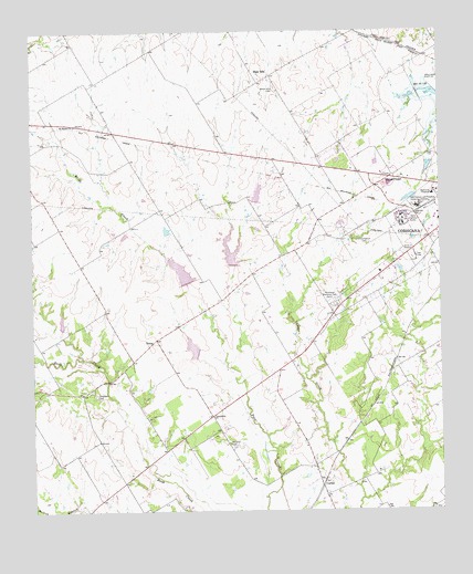
Corbet, TX USGS Topographic Map
Click on map above to begin viewing in our Map Viewer.

This topographic map contains these locations and features:
Feature Name Type Latitude Longitude GNIS ID View Map
Alpha Learning CenterSchoolN32.0788°W96.5058°2007356View Map
Anxiety AerodromeAirportN32.0376°W96.5316°1386437View Map
Black HillsSummitN32.1154°W96.5547°1330751View Map
Black Hills CemeteryCemeteryN32.1104°W96.5497°1330753View Map
Campbell CemeteryCemeteryN32.0304°W96.6064°1332033View Map
CorbetPopulated PlaceN32.0065°W96.5369°1378157View Map
Corsicana High SchoolSchoolN32.0874°W96.5183°2007363View Map
Cunningham CemeteryCemeteryN32.0696°W96.5219°1333815View Map
Dam Number 139DamN32.1092°W96.5008°1373337View Map
DranePopulated PlaceN32.0449°W96.5875°1378226View Map
Marshall CemeteryCemeteryN32.0177°W96.5650°1340991View Map
Mount Moriah ChurchChurchN32.1007°W96.6119°1342056View Map
Navarro College Police DepartmentBuildingN32.0772°W96.5007°2739467View Map
Navarro Regional HospitalHospitalN32.0836°W96.5036°2015729View Map
Oak ValleyPopulated PlaceN32.0335°W96.5130°1388552View Map
Odd Fellows and Rebekah Home for ChildrenLocaleN32.0790°W96.5067°1343061View Map
Pleasant Grove United Methodist ChurchChurchN32.0810°W96.5161°2023018View Map
Resthaven Memorial ParkCemeteryN32.0552°W96.5325°1345102View Map
Soil Conservation Service Site 1350 DamDamN32.0485°W96.6169°1862659View Map
Soil Conservation Service Site 1350 ReservoirReservoirN32.0497°W96.6164°1862660View Map
Soil Conservation Service Site 136 DamDamN32.1218°W96.5269°1863134View Map
Soil Conservation Service Site 136 DamDamN32.0252°W96.6036°1863240View Map
Soil Conservation Service Site 136 ReservoirReservoirN32.1218°W96.5269°1863135View Map
Soil Conservation Service Site 136 ReservoirReservoirN32.0253°W96.6051°1863241View Map
Soil Conservation Service Site 137a DamDamN32.0418°W96.5753°1859344View Map
Soil Conservation Service Site 137a ReservoirReservoirN32.0426°W96.5764°1859345View Map
Soil Conservation Service Site 137g DamDamN32.0585°W96.5769°1859338View Map
Soil Conservation Service Site 137g ReservoirReservoirN32.0585°W96.5769°1859339View Map
Soil Conservation Service Site 138 DamDamN32.0635°W96.5636°1859342View Map
Soil Conservation Service Site 138 ReservoirReservoirN32.0658°W96.5637°1859343View Map
Soil Conservation Service Site 140 DamDamN32.0802°W96.5569°1859340View Map
Soil Conservation Service Site 140 ReservoirReservoirN32.0827°W96.5558°1859341View Map
Soil Conservation Service Site 143a DamDamN32.0185°W96.5336°1863328View Map
Soil Conservation Service Site 143a ReservoirReservoirN32.0185°W96.5332°1863329View Map
Tiger FieldParkN32.0496°W96.5347°2027620View Map
Tiger FieldParkN32.0660°W96.5080°1348559View Map
Town of Oak ValleyCivilN32.0331°W96.5116°2413066View Map
Whites ChapelChurchN32.0868°W96.5150°1350014View Map

Note: Coordinates in the location and feature list above are referenced to NAD83 datum.


Copyright (C) 2008-2024 Ryan Niemi / Sunset Dynamics ... All Rights Reserved