TopoQuest Logo
Do you find TopoQuest useful?
Help keep TopoQuest running and adding new maps/features by donating!
Bitcoin:  19c7KJd3qBynnjoSw5npx9KScwjBe4ifkT
Litecoin:  LXs6TkuXGGXo1vDsWCkWVdjQX94eUKd6ui
Home View Maps Find Maps Find Places Resources & Links


Blooming Grove, Texas Topographic Map

USGS Map Title: Blooming Grove, TX
USGS Map MRC: 32096A6
DRG (GeoTIFF) Download: o32096a6.tif


Neighboring USGS Topographic Map Quads:


  Avalon, TX  
32096B7
 

  Cryer Creek, TX  
32096B6
 

  Emhouse, TX  
32096B5
 

  Frost, TX  
32096A7
 

  Blooming Grove, TX  
32096A6
 

  Corbet, TX  
32096A5
 

  Irene, TX  
31096H7
 

  Dawson, TX  
31096H6
 

  Purdon, TX  
31096H5


Map MRC Location:

N33°
W97°
N33°
W96°
H8 H7 H6 H5 H4 H3 H2 H1
G8 G7 G6 G5 G4 G3 G2 G1
F8 F7 F6 F5 F4 F3 F2 F1
E8 E7 E6 E5 E4 E3 E2 E1
D8 D7 D6 D5 D4 D3 D2 D1
C8 C7 C6 C5 C4 C3 C2 C1
B8 B7 B6 B5 B4 B3 B2 B1
A8 A7 A6 A5 A4 A3 A2 A1
N32°
W97°
N32°
W96°

Blooming Grove, TX USGS 1:24K Topographic Map Preview:
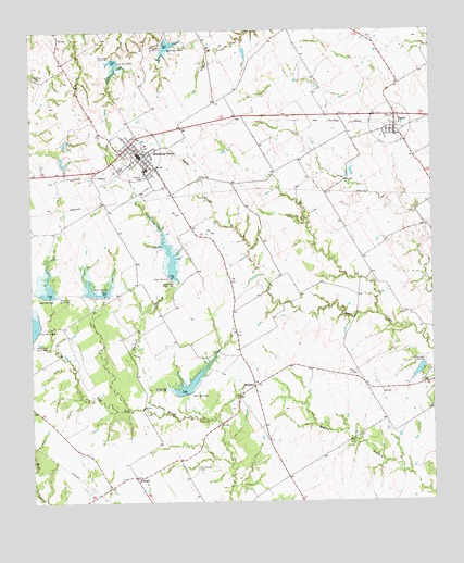
Blooming Grove, TX USGS Topographic Map
Click on map above to begin viewing in our Map Viewer.

This topographic map contains these locations and features:
Feature Name Type Latitude Longitude GNIS ID View Map
BarryPopulated PlaceN32.0993°W96.6361°1330100View Map
Barry Post OfficePost OfficeN32.0991°W96.6366°2731964View Map
Blooming GrovePopulated PlaceN32.0921°W96.7158°1330882View Map
Blooming Grove City HallBuildingN32.0913°W96.7157°2753396View Map
Blooming Grove DivisionCivilN32.0433°W96.7443°1938543View Map
Blooming Grove Post OfficePost OfficeN32.0928°W96.7167°2731688View Map
Blooming Grove Volunteer Fire DepartmentBuildingN32.0918°W96.7180°2552290View Map
Carroll BranchStreamN32.0238°W96.7094°1332198View Map
City of BarryCivilN32.0999°W96.6378°2409789View Map
Cox LakeReservoirN32.0348°W96.6295°1864286View Map
Cox Lake DamDamN32.0368°W96.6286°1864285View Map
Dam Number 105ADamN32.1180°W96.7236°1333907View Map
Dam Number 105BDamN32.1224°W96.7084°1333908View Map
Dam Number 120DamN32.0546°W96.7444°1333916View Map
Dam Number 121DamN32.0552°W96.7272°1333917View Map
Dam Number 123DamN32.0596°W96.7064°1333918View Map
Dam Number 124DamN32.0288°W96.7019°1333919View Map
DresdenPopulated PlaceN32.0307°W96.6805°1378228View Map
Lone Oak CemeteryCemeteryN32.1129°W96.7492°1340382View Map
Old Raleigh CemeteryCemeteryN32.0090°W96.6989°1343197View Map
RaleighPopulated PlaceN32.0090°W96.6989°1378927View Map
Soil Conservation Service Site 105a DamDamN32.1185°W96.7219°1859358View Map
Soil Conservation Service Site 105a ReservoirReservoirN32.1185°W96.7219°1859359View Map
Soil Conservation Service Site 105b DamDamN32.1218°W96.7086°1859346View Map
Soil Conservation Service Site 105b ReservoirReservoirN32.1218°W96.7086°1859347View Map
Soil Conservation Service Site 119a DamDamN32.0447°W96.7488°1859350View Map
Soil Conservation Service Site 120 DamDamN32.0545°W96.7459°1859352View Map
Soil Conservation Service Site 120 ReservoirReservoirN32.0564°W96.7450°1859353View Map
Soil Conservation Service Site 121 DamDamN32.0550°W96.7301°1859348View Map
Soil Conservation Service Site 121 ReservoirReservoirN32.0556°W96.7273°1859349View Map
Soil Conservation Service Site 123 DamDamN32.0597°W96.7074°1859354View Map
Soil Conservation Service Site 123 ReservoirReservoirN32.0622°W96.7064°1859355View Map
Soil Conservation Service Site 124 DamDamN32.0288°W96.7016°1859356View Map
Soil Conservation Service Site 124 ReservoirReservoirN32.0306°W96.7019°1859357View Map
Soil Conservation Service Site 134 DamDamN32.0635°W96.6569°1862653View Map
Soil Conservation Service Site 134 ReservoirReservoirN32.0635°W96.6569°1862654View Map
Soil Conservation Service Site 135a DamDamN32.0835°W96.6453°1862655View Map
Soil Conservation Service Site 135a ReservoirReservoirN32.0836°W96.6465°1862656View Map
Soil Conservation Service Site 135b DamDamN32.0668°W96.6336°1862657View Map
Soil Conservation Service Site 135b ReservoirReservoirN32.0676°W96.6336°1862658View Map
Town of Blooming GroveCivilN32.0924°W96.7173°2411699View Map

Note: Coordinates in the location and feature list above are referenced to NAD83 datum.


Copyright (C) 2008-2025 Ryan Niemi / Sunset Dynamics ... All Rights Reserved