TopoQuest Logo
Do you find TopoQuest useful?
Help keep TopoQuest running and adding new maps/features by donating!
Bitcoin:  19c7KJd3qBynnjoSw5npx9KScwjBe4ifkT
Litecoin:  LXs6TkuXGGXo1vDsWCkWVdjQX94eUKd6ui
Home View Maps Find Maps Find Places Resources & Links


Corbett, New York Topographic Map

USGS Map Title: Corbett, NY
USGS Map MRC: 42075A1
DRG (GeoTIFF) Download: o42075a1.tif


Neighboring USGS Topographic Map Quads:


  Walton West, NY  
42075B2
 

  Walton East, NY  
42075B1
 

  Hamden, NY  
42074B8
 

  Readburn, NY  
42075A2
 

  Corbett, NY  
42075A1
 

  Downsville, NY  
42074A8
 

  Fishs Eddy, NY  
41075H2
 

  Horton, NY  
41075H1
 

  Roscoe, NY  
41074H8


Map MRC Location:

N43°
W76°
N43°
W75°
H8 H7 H6 H5 H4 H3 H2 H1
G8 G7 G6 G5 G4 G3 G2 G1
F8 F7 F6 F5 F4 F3 F2 F1
E8 E7 E6 E5 E4 E3 E2 E1
D8 D7 D6 D5 D4 D3 D2 D1
C8 C7 C6 C5 C4 C3 C2 C1
B8 B7 B6 B5 B4 B3 B2 B1
A8 A7 A6 A5 A4 A3 A2 A1
N42°
W76°
N42°
W75°

Corbett, NY USGS 1:24K Topographic Map Preview:
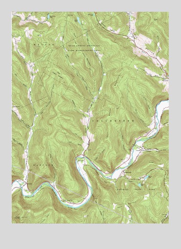
Corbett, NY USGS Topographic Map
Click on map above to begin viewing in our Map Viewer.

This topographic map contains these locations and features:
Feature Name Type Latitude Longitude GNIS ID View Map
Ash RunStreamN42.0468°W75.0641°942618View Map
Barney HollowValleyN42.0588°W75.0139°943062View Map
Baxter BrookStreamN42.0223°W75.1174°943175View Map
Baxter MountainSummitN42.0112°W75.0343°943178View Map
Bear BrookStreamN42.0793°W75.1093°943249View Map
Bear Cub PondLakeN42.1234°W75.0593°943259View Map
Bear Spring Mountain Game Management AreaParkN42.1034°W75.0693°969852View Map
Brace HillSummitN42.1204°W75.0135°944561View Map
Campbell BrookStreamN42.0465°W75.0271°945696View Map
Carcass BrookStreamN42.0562°W75.1091°945813View Map
Cherry Grove Picnic AreaLocaleN42.1223°W75.0804°946514View Map
Clauson BrookStreamN42.0215°W75.0921°946801View Map
CorbettPopulated PlaceN42.0434°W75.0218°947426View Map
Corbett Road BridgeBridgeN42.0464°W75.0273°2614889View Map
Downsville AirportAirportN42.0544°W75.0124°977987View Map
Dry BrookStreamN42.0437°W75.0671°948669View Map
East Trout BrookStreamN42.0715°W75.0607°949258View Map
Fork MountainSummitN42.1009°W75.0704°950443View Map
Fuller HollowValleyN42.0312°W75.0362°950783View Map
Gee BrookStreamN42.0418°W75.1118°950972View Map
Granger HollowValleyN42.1211°W75.1128°951497View Map
Gregory HollowValleyN42.0630°W75.0127°951795View Map
GregorytownPopulated PlaceN42.0312°W75.0363°951798View Map
Gregorytown CemeteryCemeteryN42.0283°W75.0382°951799View Map
HarvardPopulated PlaceN42.0240°W75.1127°952328View Map
Harvard CemeteryCemeteryN42.0203°W75.1146°952329View Map
Hog HollowValleyN42.0578°W75.0061°952941View Map
Horton Brook ChurchChurchN42.0054°W75.0004°953253View Map
Launt PondReservoirN42.1202°W75.0716°955081View Map
Lindsley HollowValleyN42.1116°W75.0317°955414View Map
Little Fuller BrookStreamN42.0034°W75.0027°955537View Map
Long FlatPopulated PlaceN42.0120°W75.0768°955854View Map
Long Flat CemeteryCemeteryN42.0132°W75.0826°955855View Map
Mahoney QuarryMineN42.0342°W75.0061°2567344View Map
Mellis BrookStreamN42.0976°W75.0104°956924View Map
Mills HollowValleyN42.0412°W75.0310°957351View Map
Notch HollowValleyN42.1234°W75.1224°959035View Map
Pine Mountain BranchStreamN42.0645°W75.1060°960523View Map
Possession HollowValleyN42.0595°W75.0654°961008View Map
Quinn LakeLakeN42.0275°W75.0178°962105View Map
Russ Gray PondLakeN42.1222°W75.0956°963109View Map
ShinhopplePopulated PlaceN42.0387°W75.0677°965125View Map
Stuart LakeLakeN42.0229°W75.0232°966653View Map
Thayer HollowValleyN42.0359°W75.0602°967198View Map
Trout BrookStreamN42.0393°W75.0677°967856View Map
Trout Brook MountainSummitN42.0690°W75.0463°967871View Map
Tub Mill BrookStreamN42.0868°W75.0007°967919View Map
Twadell MountainSummitN42.0031°W75.1171°968017View Map
West Trout BrookStreamN42.0715°W75.0607°970883View Map
Wilson Hollow CemeteryCemeteryN42.1099°W75.0289°971422View Map

Note: Coordinates in the location and feature list above are referenced to NAD83 datum.


Copyright (C) 2008-2024 Ryan Niemi / Sunset Dynamics ... All Rights Reserved