TopoQuest Logo
Do you find TopoQuest useful?
Help keep TopoQuest running and adding new maps/features by donating!
Bitcoin:  19c7KJd3qBynnjoSw5npx9KScwjBe4ifkT
Litecoin:  LXs6TkuXGGXo1vDsWCkWVdjQX94eUKd6ui
Home View Maps Find Maps Find Places Resources & Links


Hamden, New York Topographic Map

USGS Map Title: Hamden, NY
USGS Map MRC: 42074B8
DRG (GeoTIFF) Download: o42074b8.tif


Neighboring USGS Topographic Map Quads:


  Treadwell, NY  
42075C1
 

  Delhi, NY  
42074C8
 

  Bloomville, NY  
42074C7
 

  Walton East, NY  
42075B1
 

  Hamden, NY  
42074B8
 

  Andes, NY  
42074B7
 

  Corbett, NY  
42075A1
 

  Downsville, NY  
42074A8
 

  Lewbeach, NY  
42074A7


Map MRC Location:

N43°
W75°
N43°
W74°
H8 H7 H6 H5 H4 H3 H2 H1
G8 G7 G6 G5 G4 G3 G2 G1
F8 F7 F6 F5 F4 F3 F2 F1
E8 E7 E6 E5 E4 E3 E2 E1
D8 D7 D6 D5 D4 D3 D2 D1
C8 C7 C6 C5 C4 C3 C2 C1
B8 B7 B6 B5 B4 B3 B2 B1
A8 A7 A6 A5 A4 A3 A2 A1
N42°
W75°
N42°
W74°

Hamden, NY USGS 1:24K Topographic Map Preview:
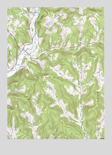
Hamden, NY USGS Topographic Map
Click on map above to begin viewing in our Map Viewer.

This topographic map contains these locations and features:
Feature Name Type Latitude Longitude GNIS ID View Map
Arbuckle HollowValleyN42.2115°W74.9090°942531View Map
Bagley BrookStreamN42.2109°W74.9724°942772View Map
Basin CloveValleyN42.1409°W74.9079°943131View Map
Bostwick CemeteryCemeteryN42.2148°W74.9725°2548321View Map
Bryden HillSummitN42.1293°W74.9271°945000View Map
Covert HollowValleyN42.2093°W74.9809°947580View Map
De LanceyPopulated PlaceN42.2056°W74.9707°948101View Map
Delaware CountyCivilN42.1981°W74.9665°974111View Map
Delhi Volunteer Fire Department Station 2BuildingN42.2107°W74.9800°2735061View Map
Devils BackboneSummitN42.2034°W74.8949°948360View Map
FraserPopulated PlaceN42.2454°W74.9646°972508View Map
Fuller HollowValleyN42.1390°W74.9677°950784View Map
Fyffe CobbleSummitN42.1954°W74.9316°950825View Map
HamdenPopulated PlaceN42.1912°W74.9946°952089View Map
Hamden CemeteryCemeteryN42.1922°W74.9842°2548320View Map
Hamden Covered BridgeBridgeN42.1958°W74.9883°2097332View Map
Holmes HollowValleyN42.2209°W74.9598°953017View Map
Launt HollowValleyN42.1908°W74.9969°955080View Map
Lucky Dog FarmLocaleN42.1900°W74.9925°2560285View Map
Platner BrookStreamN42.2423°W74.9602°970485View Map
Prospect HillSummitN42.1626°W74.9749°961169View Map
Scotch MountainSummitN42.2398°W74.9207°964668View Map
Stoddard HollowValleyN42.2109°W74.9316°966481View Map
Terry CloveValleyN42.1406°W74.9041°967175View Map
The Bullet HoleValleyN42.2170°W74.8888°967212View Map
Thompson Family CemeteryCemeteryN42.2189°W74.8767°2548322View Map
Town of HamdenCivilN42.2002°W74.9843°979037View Map
Yendes CemeteryCemeteryN42.2351°W74.9697°2548323View Map

Note: Coordinates in the location and feature list above are referenced to NAD83 datum.


Copyright (C) 2008-2024 Ryan Niemi / Sunset Dynamics ... All Rights Reserved