TopoQuest Logo
Do you find TopoQuest useful?
Help keep TopoQuest running and adding new maps/features by donating!
Bitcoin:  19c7KJd3qBynnjoSw5npx9KScwjBe4ifkT
Litecoin:  LXs6TkuXGGXo1vDsWCkWVdjQX94eUKd6ui
Home View Maps Find Maps Find Places Resources & Links


Corbin, Kentucky Topographic Map

USGS Map Title: Corbin, KY
USGS Map MRC: 36084H1
DRG (GeoTIFF) Download: o36084h1.tif


Neighboring USGS Topographic Map Quads:


  London SW, KY  
37084A2
 

  Lily, KY  
37084A1
 

  Blackwater, KY  
37083A8
 

  Vox, KY  
36084H2
 

  Corbin, KY  
36084H1
 

  Heidrick, KY  
36083H8
 

  Wofford, KY  
36084G2
 

  Rockholds, KY  
36084G1
 

  Barbourville, KY  
36083G8


Map MRC Location:

N37°
W85°
N37°
W84°
H8 H7 H6 H5 H4 H3 H2 H1
G8 G7 G6 G5 G4 G3 G2 G1
F8 F7 F6 F5 F4 F3 F2 F1
E8 E7 E6 E5 E4 E3 E2 E1
D8 D7 D6 D5 D4 D3 D2 D1
C8 C7 C6 C5 C4 C3 C2 C1
B8 B7 B6 B5 B4 B3 B2 B1
A8 A7 A6 A5 A4 A3 A2 A1
N36°
W85°
N36°
W84°

Corbin, KY USGS 1:24K Topographic Map Preview:
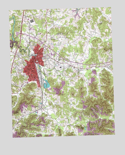
Corbin, KY USGS Topographic Map
Click on map above to begin viewing in our Map Viewer.

This topographic map contains these locations and features:
Feature Name Type Latitude Longitude GNIS ID View Map
Bacon CreekStreamN36.9215°W84.0858°510336View Map
Bacon Creek Baptist ChurchChurchN36.9179°W84.1177°510337View Map
Baptist Health Hospital CorbinHospitalN36.9228°W84.1197°2660403View Map
Bingham BranchStreamN36.9229°W84.1119°510731View Map
Bingham CemeteryCemeteryN36.9276°W84.1194°510733View Map
Calvary Baptist ChurchChurchN36.9418°W84.0398°2543236View Map
Camp GroundsPopulated PlaceN36.9720°W84.0722°511154View Map
Candle RidgeRidgeN36.9207°W84.0191°2543239View Map
Candle Ridge ChurchChurchN36.9234°W84.0152°511176View Map
Central SchoolSchoolN36.9418°W84.1027°511305View Map
Chapel Grove Baptist ChurchChurchN36.8862°W84.0469°511315View Map
City of CorbinCivilN36.9320°W84.1003°2404128View Map
CorbinPopulated PlaceN36.9487°W84.0969°511536View Map
Corbin DivisionCivilN36.9322°W84.0479°1936948View Map
Corbin Fire Department Station 1BuildingN36.9420°W84.0945°2636492View Map
Corbin Fire Department Station 2BuildingN36.9322°W84.0958°2637305View Map
Corbin Fire Department Station 3BuildingN36.9530°W84.0841°2637306View Map
Corbin Municipal Golf CourseLocaleN36.9445°W84.0473°2554748View Map
Corbin Police DepartmentBuildingN36.9421°W84.0946°2767633View Map
Corn CreekStreamN36.8862°W84.0697°511546View Map
Corn Creek Baptist ChurchChurchN36.8837°W84.0852°511547View Map
DorthaePopulated PlaceN36.9934°W84.1047°511869View Map
Dorthae ChurchChurchN36.9865°W84.1016°511870View Map
Dorthae Depot (historical)LocaleN36.9930°W84.1049°2723148View Map
East Fork Lynn Camp CreekStreamN36.9418°W84.0880°511990View Map
East Ward SchoolSchoolN36.9520°W84.0883°511997View Map
Eaton BranchStreamN36.8998°W84.0819°512002View Map
Felts Chapel Methodist ChurchChurchN36.9751°W84.0908°512144View Map
Felts Chapel SchoolSchoolN36.9662°W84.0952°512145View Map
GrayPopulated PlaceN36.9426°W84.0083°512406View Map
Gray Census Designated PlaceCensusN36.9432°W84.0058°2629624View Map
Gray Post OfficePost OfficeN36.9443°W84.0086°2543275View Map
Gray School (historical)SchoolN36.9437°W84.0104°2543276View Map
Hart CemeteryCemeteryN36.9217°W84.0919°512575View Map
Harts CemeteryCemeteryN36.9320°W84.0646°512578View Map
Harts ChapelChurchN36.9345°W84.0655°512579View Map
Hazel ForkStreamN36.9362°W84.0374°512620View Map
Henry Field (historical)AirportN36.9598°W84.0763°516772View Map
HopewellPopulated PlaceN36.9926°W84.0919°512778View Map
Horse CreekStreamN36.9637°W84.1024°512792View Map
Horse Creek ChurchChurchN36.9901°W84.0638°512794View Map
Liberty CemeteryCemeteryN36.9073°W84.0544°513370View Map
Liberty ChurchChurchN36.9095°W84.0527°513371View Map
Liberty School (historical)SchoolN36.9104°W84.0526°2543302View Map
Lily Volunteer Fire Department Station 3BuildingN36.9915°W84.0951°2637313View Map
Lynn Camp ChurchChurchN36.9498°W84.0541°513738View Map
Lynn Camp CreekStreamN36.9689°W84.1199°513739View Map
Lynn Camp SchoolSchoolN36.9498°W84.0652°513740View Map
McFarland CemeteryCemeteryN36.8987°W84.1085°513861View Map
Mills ForkStreamN36.8904°W84.0010°514017View Map
Moore HillPopulated PlaceN36.9356°W84.0813°514044View Map
Negro CreekStreamN36.9337°W84.0324°514219View Map
North CorbinPopulated PlaceN36.9606°W84.0933°514286View Map
North Corbin Census Designated PlaceCensusN36.9649°W84.0973°2403345View Map
North Side ChurchChurchN36.9862°W84.0808°514296View Map
Oak Ridge ChurchChurchN36.9756°W84.0602°514302View Map
Park Hill ChurchChurchN36.9623°W84.0827°514433View Map
Pine Hill CemeteryCemeteryN36.9566°W84.0838°514584View Map
Piney Grove ChurchChurchN36.9501°W84.0780°514610View Map
Place Post Office (historical)Post OfficeN36.9413°W84.0399°2543330View Map
Poplar Grove ChurchChurchN36.9756°W84.0213°514714View Map
Rest Haven CemeteryCemeteryN36.9605°W84.0822°514892View Map
Saint Camillus AcademySchoolN36.9515°W84.0847°515174View Map
Sharp CemeteryCemeteryN36.8801°W84.0758°515338View Map
SilerPopulated PlaceN36.9412°W84.0397°515407View Map
South Ward SchoolSchoolN36.9337°W84.0966°515559View Map
Spider CreekStreamN36.9415°W84.0719°515595View Map
Steel HollowValleyN36.8766°W84.0873°515675View Map
Steel Post Office (historical)Post OfficeN36.9065°W84.0394°2554735View Map
Steels Mill (historical)LocaleN36.9410°W84.0404°2543348View Map
Stewarts CreekStreamN36.8823°W84.0624°515701View Map
Stony ForkStreamN36.9395°W84.0424°515734View Map
Suprise ChurchChurchN36.9379°W84.0419°515819View Map
WatchLocaleN36.9551°W84.0460°516240View Map
Watch Post Office (historical)Post OfficeN36.9550°W84.0462°2543372View Map
WCTT-AM (Corbin)TowerN36.9026°W84.0805°517788View Map
WCTT-FM (Corbin)TowerN36.9026°W84.0819°517937View Map
West Knox Fire Department Station 1BuildingN36.9505°W84.0687°2637286View Map
West Knox Fire Department Station 2BuildingN36.9644°W84.0904°2636677View Map
Whipporwill Post Office (historical)Post OfficeN36.9644°W84.1048°2712116View Map
WiltonPopulated PlaceN36.8904°W84.0474°516413View Map
Wilton Junction (historical)LocaleN36.9016°W84.0919°2710265View Map
Wilton LakeReservoirN36.8820°W84.0360°516414View Map
Wilton Post Office (historical)Post OfficeN36.8906°W84.0470°2543376View Map
WKDP-AM (Corbin)TowerN36.9390°W84.0788°517790View Map
WKYZ-AM (Gray)TowerN36.9456°W84.0191°517816View Map
WoodbinePopulated PlaceN36.9048°W84.0888°516470View Map
Woodbine Census Designated PlaceCensusN36.9047°W84.0913°2629703View Map
Woodbine Fire and Rescue Department Station 1BuildingN36.8950°W84.0793°2636827View Map
Woodbine Fire and Rescue Department Station 3BuildingN36.9037°W84.0881°2637316View Map
WVCT-FM (Keavy)TowerN36.9726°W84.1244°517969View Map
Youngs CreekStreamN36.9381°W84.0633°516520View Map

Note: Coordinates in the location and feature list above are referenced to NAD83 datum.


Copyright (C) 2008-2024 Ryan Niemi / Sunset Dynamics ... All Rights Reserved