TopoQuest Logo
Do you find TopoQuest useful?
Help keep TopoQuest running and adding new maps/features by donating!
Bitcoin:  19c7KJd3qBynnjoSw5npx9KScwjBe4ifkT
Litecoin:  LXs6TkuXGGXo1vDsWCkWVdjQX94eUKd6ui
Home View Maps Find Maps Find Places Resources & Links


Cordes Junction, Arizona Topographic Map

USGS Map Title: Cordes Junction, AZ
USGS Map MRC: 34112C1
DRG (GeoTIFF) Download: o34112c1.tif


Neighboring USGS Topographic Map Quads:


  Mayer, AZ  
34112D2
 

  Estler Peak, AZ  
34112D1
 

  Arnold Mesa, AZ  
34111D8
 

  Cleator, AZ  
34112C2
 

  Cordes Junction, AZ  
34112C1
 

  Dugas, AZ  
34111C8
 

  Bumble Bee, AZ  
34112B2
 

  Joes Hill, AZ  
34112B1
 

  Brooklyn Peak, AZ  
34111B8


Map MRC Location:

N35°
W113°
N35°
W112°
H8 H7 H6 H5 H4 H3 H2 H1
G8 G7 G6 G5 G4 G3 G2 G1
F8 F7 F6 F5 F4 F3 F2 F1
E8 E7 E6 E5 E4 E3 E2 E1
D8 D7 D6 D5 D4 D3 D2 D1
C8 C7 C6 C5 C4 C3 C2 C1
B8 B7 B6 B5 B4 B3 B2 B1
A8 A7 A6 A5 A4 A3 A2 A1
N34°
W113°
N34°
W112°

Cordes Junction, AZ USGS 1:24K Topographic Map Preview:
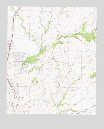
Cordes Junction, AZ USGS Topographic Map
Click on map above to begin viewing in our Map Viewer.

This topographic map contains these locations and features:
Feature Name Type Latitude Longitude GNIS ID View Map
ArcosantiPopulated PlaceN34.3431°W112.1007°38221View Map
Arizona Highway Maintenance YardLocaleN34.3306°W112.1215°43416View Map
Ash CreekStreamN34.3261°W112.0757°25788View Map
Balmes RanchLocaleN34.3078°W112.0552°41015View Map
Big Bug CreekStreamN34.3150°W112.0665°26244View Map
Black Hill WashStreamN34.3117°W112.0557°26391View Map
Bloody Basin InterchangeCrossingN34.2842°W112.1204°26495View Map
Burmister RanchLocaleN34.3270°W112.0715°41014View Map
Cactus BasinBasinN34.3156°W112.0271°27159View Map
Community Bible ChurchChurchN34.3102°W112.1110°2670794View Map
Cordes JunctionPopulated PlaceN34.3323°W112.1204°27941View Map
Cordes Junction InterchangeCrossingN34.3292°W112.1207°38368View Map
Cordes LakesPopulated PlaceN34.3078°W112.1035°38369View Map
Cordes Lakes Census Designated PlaceCensusN34.3103°W112.1073°2407661View Map
Cordes Lakes Public LibraryBuildingN34.3111°W112.1045°2669406View Map
Dry CreekStreamN34.3578°W112.0660°28626View Map
First Baptist ChurchChurchN34.3143°W112.1090°2670939View Map
Horseshoe RanchLocaleN34.2611°W112.0582°30196View Map
Indian CreekStreamN34.2584°W112.0590°30333View Map
Little Ash CreekStreamN34.3459°W112.0715°31029View Map
Long GulchValleyN34.2617°W112.0513°31240View Map
Mayer Fire Department Fire Station 23BuildingN34.3064°W112.1042°2672526View Map
Mountain of Faith Lutheran ChurchChurchN34.3149°W112.1097°2671249View Map
Red Rock GulchValleyN34.2950°W112.0213°33499View Map
Sheep GulchValleyN34.2842°W112.0513°34332View Map
Sycamore CreekStreamN34.3245°W112.0707°35033View Map
Sycamore MesaSummitN34.3203°W112.0154°35037View Map

Note: Coordinates in the location and feature list above are referenced to NAD83 datum.


Copyright (C) 2008-2024 Ryan Niemi / Sunset Dynamics ... All Rights Reserved