TopoQuest Logo
Do you find TopoQuest useful?
Help keep TopoQuest running and adding new maps/features by donating!
Bitcoin:  19c7KJd3qBynnjoSw5npx9KScwjBe4ifkT
Litecoin:  LXs6TkuXGGXo1vDsWCkWVdjQX94eUKd6ui
Home View Maps Find Maps Find Places Resources & Links


Cleator, Arizona Topographic Map

USGS Map Title: Cleator, AZ
USGS Map MRC: 34112C2
DRG (GeoTIFF) Download: o34112c2.tif


Neighboring USGS Topographic Map Quads:


  Poland Junction, AZ  
34112D3
 

  Mayer, AZ  
34112D2
 

  Estler Peak, AZ  
34112D1
 

  Battle Flat, AZ  
34112C3
 

  Cleator, AZ  
34112C2
 

  Cordes Junction, AZ  
34112C1
 

  Crown King, AZ  
34112B3
 

  Bumble Bee, AZ  
34112B2
 

  Joes Hill, AZ  
34112B1


Map MRC Location:

N35°
W113°
N35°
W112°
H8 H7 H6 H5 H4 H3 H2 H1
G8 G7 G6 G5 G4 G3 G2 G1
F8 F7 F6 F5 F4 F3 F2 F1
E8 E7 E6 E5 E4 E3 E2 E1
D8 D7 D6 D5 D4 D3 D2 D1
C8 C7 C6 C5 C4 C3 C2 C1
B8 B7 B6 B5 B4 B3 B2 B1
A8 A7 A6 A5 A4 A3 A2 A1
N34°
W113°
N34°
W112°

Cleator, AZ USGS 1:24K Topographic Map Preview:
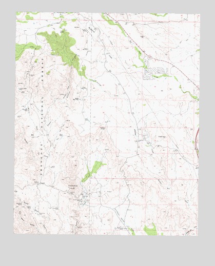
Cleator, AZ USGS Topographic Map
Click on map above to begin viewing in our Map Viewer.

This topographic map contains these locations and features:
Feature Name Type Latitude Longitude GNIS ID View Map
Antelope CreekStreamN34.2773°W112.1471°25664View Map
Blanchard SpringSpringN34.2677°W112.2451°26475View Map
Blue Bell (historical)LocaleN34.3370°W112.2143°42734View Map
Blue Bell MineMineN34.3395°W112.2410°26503View Map
Blue Bell Tank Number TwoReservoirN34.3395°W112.2327°41001View Map
Blue Bell Trick TankReservoirN34.3439°W112.2252°41011View Map
Blue Bell WellWellN34.3231°W112.2263°41002View Map
Cedar CanyonValleyN34.2950°W112.2271°27405View Map
Cedar CreekStreamN34.2945°W112.2257°27411View Map
Cedar WellWellN34.3545°W112.2332°38324View Map
CleatorPopulated PlaceN34.2786°W112.2329°27704View Map
CordesPopulated PlaceN34.3034°W112.1668°27940View Map
Cordes Airport (historical)AirportN34.3052°W112.1646°1764987View Map
Cordes PeakSummitN34.3056°W112.1482°27942View Map
Dripping SpringSpringN34.3101°W112.1894°28599View Map
French Lilly MineMineN34.2611°W112.2335°29194View Map
Geary SpringSpringN34.3644°W112.2182°29285View Map
Golden Belt MineMineN34.2723°W112.2040°29395View Map
Golden Turkey MineMineN34.2698°W112.2052°29399View Map
Gray Goose MineMineN34.2659°W112.2196°29557View Map
Hackberry CreekStreamN34.3450°W112.1640°29664View Map
Hidden Treasure MineMineN34.2539°W112.1788°29951View Map
Hook TankReservoirN34.3058°W112.2376°30094View Map
Jubilee MineMineN34.3159°W112.2493°30637View Map
Jubilee SpringSpringN34.3183°W112.2294°41003View Map
Little Cedar TankReservoirN34.3558°W112.2495°38570View Map
Lower RR TankReservoirN34.3544°W112.2018°31374View Map
Mayer Fire Department Fire Station 22BuildingN34.3712°W112.1828°2672653View Map
Mayer Fire Department Fire Station 24BuildingN34.3433°W112.1641°2672527View Map
Mayer Junior Senior High SchoolSchoolN34.3463°W112.1565°38613View Map
Mesa TankReservoirN34.3145°W112.2007°31730View Map
Middle Mesa TankReservoirN34.3263°W112.2067°31816View Map
Mineral CreekStreamN34.2945°W112.2268°31904View Map
OcotilloPopulated PlaceN34.3636°W112.2018°42749View Map
Poor Mans GulchValleyN34.2503°W112.2318°33104View Map
Powerline TankReservoirN34.3206°W112.2430°33175View Map
Quail SpringSpringN34.2654°W112.2418°33250View Map
RR TankReservoirN34.3666°W112.2077°33300View Map
Saint Johns MineMineN34.2739°W112.2124°33958View Map
Silver Cord MineMineN34.2548°W112.2054°34430View Map
Spring ValleyPopulated PlaceN34.3450°W112.1590°38837View Map
Spring Valley Census Designated PlaceCensusN34.3531°W112.1513°2408795View Map
Spring Valley Community ChurchChurchN34.3416°W112.1626°2671820View Map
Susie Hendrick PlaceLocaleN34.3667°W112.2418°41010View Map
Swiettendick PlaceLocaleN34.3639°W112.2424°2040934View Map
Swiettendick Place WellWellN34.3645°W112.2452°38854View Map
Townsend ButteSummitN34.2767°W112.2113°35426View Map
Upper Mesa TankReservoirN34.3317°W112.2045°35698View Map
Upper RR TankReservoirN34.3654°W112.2055°35706View Map
White TankReservoirN34.3057°W112.2180°36114View Map
Yellow Jacket TankReservoirN34.3317°W112.2479°36463View Map

Note: Coordinates in the location and feature list above are referenced to NAD83 datum.


Copyright (C) 2008-2024 Ryan Niemi / Sunset Dynamics ... All Rights Reserved