TopoQuest Logo
Do you find TopoQuest useful?
Help keep TopoQuest running and adding new maps/features by donating!
Bitcoin:  19c7KJd3qBynnjoSw5npx9KScwjBe4ifkT
Litecoin:  LXs6TkuXGGXo1vDsWCkWVdjQX94eUKd6ui
Home View Maps Find Maps Find Places Resources & Links


Cortland, Ohio Topographic Map

USGS Map Title: Cortland, OH
USGS Map MRC: 41080C6
DRG (GeoTIFF) Download: o41080c6.tif


Neighboring USGS Topographic Map Quads:


  Bristolville, OH  
41080D7
 

  Gustavus, OH  
41080D6
 

  Kinsman, OH  
41080D5
 

  Champion, OH  
41080C7
 

  Cortland, OH  
41080C6
 

  Orangeville, OH  
41080C5
 

  Warren, OH  
41080B7
 

  Girard, OH  
41080B6
 

  Sharon West, PA  
41080B5


Map MRC Location:

N42°
W81°
N42°
W80°
H8 H7 H6 H5 H4 H3 H2 H1
G8 G7 G6 G5 G4 G3 G2 G1
F8 F7 F6 F5 F4 F3 F2 F1
E8 E7 E6 E5 E4 E3 E2 E1
D8 D7 D6 D5 D4 D3 D2 D1
C8 C7 C6 C5 C4 C3 C2 C1
B8 B7 B6 B5 B4 B3 B2 B1
A8 A7 A6 A5 A4 A3 A2 A1
N41°
W81°
N41°
W80°

Cortland, OH USGS 1:24K Topographic Map Preview:
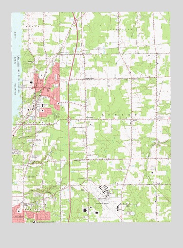
Cortland, OH USGS Topographic Map
Click on map above to begin viewing in our Map Viewer.

This topographic map contains these locations and features:
Feature Name Type Latitude Longitude GNIS ID View Map
Allen AirportAirportN41.3731°W80.6688°1082628View Map
Bazetta Fire Department Station 13BuildingN41.2900°W80.7416°2550662View Map
Bazetta Township Police DepartmentBuildingN41.2901°W80.7422°2732446View Map
Cadwallader CemeteryCemeteryN41.2670°W80.7195°1038599View Map
Casterline CemeteryCemeteryN41.3235°W80.7290°1038868View Map
Chadwick CornersLocaleN41.2753°W80.6904°1060946View Map
City of CortlandCivilN41.3318°W80.7192°2393640View Map
CortlandPopulated PlaceN41.3303°W80.7254°1056839View Map
Cortland Christian ChurchChurchN41.3287°W80.7276°1807238View Map
Cortland Christian Church CemeteryCemeteryN41.3284°W80.7276°1039090View Map
Cortland City Fire DepartmentBuildingN41.3312°W80.7285°2550583View Map
Cortland Elementary SchoolSchoolN41.3345°W80.7270°1050740View Map
Cortland First Church of GodChurchN41.3203°W80.7301°1807239View Map
Cortland HeliportAirportN41.3209°W80.7331°1082627View Map
Cortland Police DepartmentBuildingN41.3380°W80.7230°2732927View Map
Cortland Post OfficePost OfficeN41.3306°W80.7248°2056257View Map
Cortland United Methodist ChurchChurchN41.3317°W80.7265°1062015View Map
Currys CornersLocaleN41.3503°W80.6359°1039545View Map
Doud CemeteryCemeteryN41.2713°W80.7036°1039759View Map
Dugan CemeteryCemeteryN41.2975°W80.6354°1039858View Map
Four Seasons Mobile Home ParkPopulated PlaceN41.2553°W80.6589°2513473View Map
FowlerPopulated PlaceN41.3112°W80.6556°1080493View Map
Fowler Center CemeteryCemeteryN41.3128°W80.6548°1961532View Map
Fowler Center Historic DistrictParkN41.3112°W80.6556°1071666View Map
Fowler Community ChurchChurchN41.3117°W80.6512°1062017View Map
Fowler Fire DepartmentBuildingN41.3090°W80.6553°2549841View Map
Fowler Mobile Home CourtPopulated PlaceN41.2956°W80.6372°2513493View Map
Fowler Post OfficePost OfficeN41.3112°W80.6554°2060036View Map
Fowler RidgeRidgeN41.3114°W80.6917°1080494View Map
Fowler United Methodist ChurchChurchN41.3101°W80.6551°1062016View Map
Governor FarmsLocaleN41.3261°W80.7367°2707321View Map
Herr PondReservoirN41.2899°W80.7197°1078216View Map
Herr Pond DamDamN41.2917°W80.7215°1078215View Map
Hillside CemeteryCemeteryN41.3314°W80.7420°1048335View Map
Hillside Rehabilitation HospitalBuildingN41.2506°W80.7325°1050739View Map
Howland CenterPopulated PlaceN41.2512°W80.7454°1867457View Map
Howland Glen Elementary SchoolSchoolN41.2567°W80.7445°1050810View Map
Howland Township CemeteryCemeteryN41.2523°W80.7395°1961535View Map
Johnston StationLocaleN41.3539°W80.6656°1071057View Map
Kellogg CornersLocaleN41.3351°W80.6926°1042207View Map
King CornersPopulated PlaceN41.2609°W80.7406°1064940View Map
Lakeview High SchoolSchoolN41.3201°W80.7256°1042394View Map
Lakeview Shopping CenterLocaleN41.3087°W80.7304°1056597View Map
Neal Middle SchoolSchoolN41.3089°W80.6567°1050741View Map
NutwoodPopulated PlaceN41.3112°W80.6362°1065181View Map
Nutwood Post Office (historical)Post OfficeN41.3112°W80.6359°2060383View Map
Rand CemeteryCemeteryN41.3117°W80.6923°1961546View Map
Saint Roberts ChurchChurchN41.3453°W80.7334°1061650View Map
Schwartz FarmsLocaleN41.3372°W80.6681°2707319View Map
Sheldon CemeteryCemeteryN41.3356°W80.6587°1046173View Map
Sheldon CornersLocaleN41.3356°W80.6554°1046174View Map
Tamer Win Country ClubLocaleN41.2995°W80.7312°1080207View Map
Township of FowlerCivilN41.3105°W80.6633°1087029View Map
TyrrellPopulated PlaceN41.2723°W80.6362°1063071View Map
Tyrrell Post Office (historical)Post OfficeN41.2723°W80.6359°2056302View Map
Venice HeightsPopulated PlaceN41.2528°W80.7406°1049273View Map
Walnut CreekStreamN41.3214°W80.7417°1067038View Map
Youngstown Air Reserve Station Fire DepartmentBuildingN41.2663°W80.6760°2550646View Map
Youngstown-Warren Air Reserve StationMilitaryN41.2681°W80.6763°2512396View Map
Youngstown-Warren Regional AirportAirportN41.2572°W80.6672°1083146View Map

Note: Coordinates in the location and feature list above are referenced to NAD83 datum.


Copyright (C) 2008-2025 Ryan Niemi / Sunset Dynamics ... All Rights Reserved