TopoQuest Logo
Do you find TopoQuest useful?
Help keep TopoQuest running and adding new maps/features by donating!
Bitcoin:  19c7KJd3qBynnjoSw5npx9KScwjBe4ifkT
Litecoin:  LXs6TkuXGGXo1vDsWCkWVdjQX94eUKd6ui
Home View Maps Find Maps Find Places Resources & Links


Orangeville, Ohio Topographic Map

USGS Map Title: Orangeville, OH
USGS Map MRC: 41080C5
DRG (GeoTIFF) Download: o41080c5.tif


Neighboring USGS Topographic Map Quads:


  Gustavus, OH  
41080D6
 

  Kinsman, OH  
41080D5
 

  Greenville West, PA  
41080D4
 

  Cortland, OH  
41080C6
 

  Orangeville, OH  
41080C5
 

  Sharpsville, PA  
41080C4
 

  Girard, OH  
41080B6
 

  Sharon West, PA  
41080B5
 

  Sharon East, PA  
41080B4


Map MRC Location:

N42°
W81°
N42°
W80°
H8 H7 H6 H5 H4 H3 H2 H1
G8 G7 G6 G5 G4 G3 G2 G1
F8 F7 F6 F5 F4 F3 F2 F1
E8 E7 E6 E5 E4 E3 E2 E1
D8 D7 D6 D5 D4 D3 D2 D1
C8 C7 C6 C5 C4 C3 C2 C1
B8 B7 B6 B5 B4 B3 B2 B1
A8 A7 A6 A5 A4 A3 A2 A1
N41°
W81°
N41°
W80°

Orangeville, OH USGS 1:24K Topographic Map Preview:
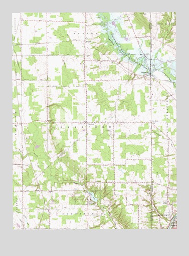
Orangeville, OH USGS Topographic Map
Click on map above to begin viewing in our Map Viewer.

This topographic map contains these locations and features:
Feature Name Type Latitude Longitude GNIS ID View Map
Antietam (historical)Populated PlaceN41.3326°W80.5984°1065541View Map
Antietam Post Office (historical)Post OfficeN41.3320°W80.5984°2059882View Map
Artherholt CemeteryCemeteryN41.2610°W80.5558°1037492View Map
Big RunStreamN41.2542°W80.5048°1037994View Map
Big RunStreamN41.2539°W80.5037°1169568View Map
Booth RunStreamN41.3417°W80.5151°1198464View Map
Brockway (historical)Populated PlaceN41.2773°W80.5684°1050743View Map
Brockway Post Office (historical)Post OfficeN41.2778°W80.5679°2059936View Map
BurghillPopulated PlaceN41.3595°W80.5684°1060908View Map
Burghill Baptist ChurchChurchN41.3548°W80.5698°1062020View Map
Burghill CemeteryCemeteryN41.3504°W80.5681°1038530View Map
Burghill Post OfficePost OfficeN41.3598°W80.5679°2056256View Map
Clark HillSummitN41.2739°W80.5098°1171911View Map
Five PointsCapeN41.3114°W80.5187°1174861View Map
Five PointsPopulated PlaceN41.3114°W80.5190°1062766View Map
HartfordPopulated PlaceN41.3114°W80.5684°1064804View Map
Hartford Center CemeteryCemeteryN41.3106°W80.5703°1961534View Map
Hartford Community ChurchChurchN41.3109°W80.5681°1062019View Map
Hartford Elementary SchoolSchoolN41.3117°W80.5692°1050742View Map
Hartford OrchardsLocaleN41.3144°W80.5731°2515672View Map
Hartford Post OfficePost OfficeN41.3112°W80.5679°2060038View Map
Hartford Township Volunteer Fire DepartmentBuildingN41.3123°W80.5695°2549570View Map
Hartford United Methodist ChurchChurchN41.3112°W80.5731°1062018View Map
Kenley AirportAirportN41.2913°W80.5677°1082733View Map
LatimerPopulated PlaceN41.3567°W80.6179°1062846View Map
Latimer Post Office (historical)Post OfficeN41.3570°W80.6179°2060049View Map
OrangevillePopulated PlaceN41.3392°W80.5190°1065212View Map
Orangeville CemeteryCemeteryN41.3442°W80.5178°1183017View Map
Orangeville Post OfficePost OfficeN41.3389°W80.5192°2060042View Map
Orangeville Volunteer Fire DepartmentBuildingN41.3358°W80.5209°2549832View Map
Port Sember Airport (historical)AirportN41.3109°W80.5137°1194209View Map
Saint Marys CemeteryCemeteryN41.2653°W80.5081°1186400View Map
Sharon SpeedwayLocaleN41.3062°W80.5487°1080193View Map
South Branch Yankee RunStreamN41.2926°W80.5995°1046442View Map
Storeyland Christmas Tree FarmLocaleN41.3594°W80.5633°2647891View Map
Thornton RunStreamN41.2548°W80.5028°1209345View Map
Township of HartfordCivilN41.3102°W80.5702°1087032View Map
Trautman HillSummitN41.3739°W80.5217°1049249View Map
Village of OrangevilleCivilN41.3417°W80.5283°1087042View Map
Village of Yankee LakeCivilN41.2683°W80.5690°2399750View Map
WeldonPopulated PlaceN41.2770°W80.5470°1050744View Map
Weldon Post Office (historical)Post OfficeN41.2764°W80.5470°2062028View Map
West Street CemeteryCemeteryN41.3117°W80.5956°1047803View Map
Yankee LakePopulated PlaceN41.2667°W80.5676°1049353View Map
Yankee LakeReservoirN41.2667°W80.5598°1078214View Map
Yankee Lake DamDamN41.2667°W80.5598°1078213View Map

Note: Coordinates in the location and feature list above are referenced to NAD83 datum.


Copyright (C) 2008-2024 Ryan Niemi / Sunset Dynamics ... All Rights Reserved