TopoQuest Logo
Do you find TopoQuest useful?
Help keep TopoQuest running and adding new maps/features by donating!
Bitcoin:  19c7KJd3qBynnjoSw5npx9KScwjBe4ifkT
Litecoin:  LXs6TkuXGGXo1vDsWCkWVdjQX94eUKd6ui
Home View Maps Find Maps Find Places Resources & Links


Counce, Tennessee Topographic Map

USGS Map Title: Counce, TN
USGS Map MRC: 35088A3
DRG (GeoTIFF) Download: o35088a3.tif


Neighboring USGS Topographic Map Quads:


  Stantonville, TN  
35088B4
 

  Pittsburg Landing, TN  
35088B3
 

  Savannah, TN  
35088B2
 

  Michie, TN  
35088A4
 

  Counce, TN  
35088A3
 

  Pickwick, TN  
35088A2
 

  Kendrick, MS  
34088H4
 

  Doskie, MS  
34088H3
 

  Yellow Creek, MS  
34088H2


Map MRC Location:

N36°
W89°
N36°
W88°
H8 H7 H6 H5 H4 H3 H2 H1
G8 G7 G6 G5 G4 G3 G2 G1
F8 F7 F6 F5 F4 F3 F2 F1
E8 E7 E6 E5 E4 E3 E2 E1
D8 D7 D6 D5 D4 D3 D2 D1
C8 C7 C6 C5 C4 C3 C2 C1
B8 B7 B6 B5 B4 B3 B2 B1
A8 A7 A6 A5 A4 A3 A2 A1
N35°
W89°
N35°
W88°

Counce, TN USGS 1:24K Topographic Map Preview:
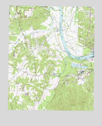
Counce, TN USGS Topographic Map
Click on map above to begin viewing in our Map Viewer.

This topographic map contains these locations and features:
Feature Name Type Latitude Longitude GNIS ID View Map
Austin HollowValleyN35.1061°W88.2501°1276000View Map
Barbwood BranchStreamN35.0862°W88.2803°1276287View Map
Barnes BranchStreamN35.0848°W88.2525°1276343View Map
Batey BranchStreamN35.0904°W88.3500°1276468View Map
Battles BranchStreamN35.0195°W88.3103°1276484View Map
Bellis DockLocaleN35.0648°W88.2692°1276966View Map
Beshears CemeteryCemeteryN35.0495°W88.3620°1277070View Map
Bethel ChurchChurchN35.0381°W88.2714°1323728View Map
Bethel School (historical)SchoolN35.0381°W88.2717°1323729View Map
Big BendBendN35.0751°W88.2795°1277229View Map
Big Bend ShoalsBarN35.0662°W88.2831°1313240View Map
Blevins BranchStreamN35.0818°W88.2564°1277686View Map
Bluff Spring BranchStreamN35.0195°W88.3103°1277835View Map
Booker BranchStreamN35.0734°W88.3509°1277967View Map
Browder BranchStreamN35.1126°W88.3134°1278499View Map
Brown CemeteryCemeteryN35.0842°W88.2548°1323745View Map
Callens DockLocaleN35.0645°W88.2681°1279335View Map
Callens Ferry (historical)CrossingN35.0631°W88.2662°1313247View Map
Center Hill BranchStreamN35.0431°W88.2995°1280128View Map
Center Hill ChurchChurchN35.0462°W88.3187°1305804View Map
Chambers CreekStreamN35.0614°W88.2717°668303View Map
Childers HillPopulated PlaceN35.0784°W88.3250°1280451View Map
Childers Hill CemeteryCemeteryN35.0826°W88.3245°1323758View Map
Childers Hill CemeteryCemeteryN35.0834°W88.3220°1323759View Map
Childers Hill School (historical)SchoolN35.0798°W88.3259°1323760View Map
Churchwell LandingLocaleN35.0823°W88.2923°1314845View Map
Commissioner District 3CivilN35.0365°W88.2859°2464153View Map
CouncePopulated PlaceN35.0423°W88.2734°1281377View Map
Counce CemeteryCemeteryN35.0490°W88.3086°1323766View Map
Counce Post OfficePost OfficeN35.0460°W88.2593°1652241View Map
DamonPopulated PlaceN35.0115°W88.3292°1314928View Map
District 10 (historical)CivilN35.0459°W88.3334°1310173View Map
District 6 (historical)CivilN35.1168°W88.2584°1310169View Map
Emmanuel ChurchChurchN35.1237°W88.2556°1283753View Map
Fraley FieldFlatN35.1195°W88.3556°1313258View Map
Griscoms LandingLocaleN35.1131°W88.2964°1646318View Map
HamburgPopulated PlaceN35.0948°W88.3042°1286632View Map
Hamburg Ferry (historical)CrossingN35.0981°W88.2989°1313260View Map
Hamburg LandingLocaleN35.0987°W88.3009°1323803View Map
Hardin County Fire Department / Emergency Management District 3 Station 1BuildingN35.0429°W88.2696°2654247View Map
Hardin County Fire Department / Emergency Management District 3 Station 2BuildingN35.0713°W88.3135°2654246View Map
Hardin County Fire Department / Emergency Management District 7 Station 1BuildingN35.1136°W88.2583°2654084View Map
Hatley CemeteryCemeteryN35.1065°W88.2559°1287137View Map
Hatley CemeteryCemeteryN35.1237°W88.2684°1323821View Map
Hatley CreekStreamN35.1079°W88.2967°1287140View Map
Hatley PondLakeN35.1237°W88.2764°1287142View Map
Hindman BottomBendN35.0898°W88.3345°1287865View Map
Hindman BranchStreamN35.0926°W88.3392°1287866View Map
Hoover BranchStreamN35.0262°W88.3081°1288266View Map
Hoover CemeteryCemeteryN35.0659°W88.3067°1323829View Map
Houston BranchStreamN35.0479°W88.2517°1288503View Map
Johnson SloughStreamN35.0620°W88.2939°1289655View Map
Kelley BranchStreamN35.0734°W88.3514°1289995View Map
Leath CemeteryCemeteryN35.0584°W88.3042°1323849View Map
Leath CreekStreamN35.0573°W88.2925°1290876View Map
Lick CreekStreamN35.1201°W88.3009°1291211View Map
Lick Creek CanalCanalN35.0793°W88.3653°1313266View Map
Little CreekStreamN35.0795°W88.3650°1291457View Map
Littlejohn BranchStreamN35.0048°W88.3289°1291718View Map
McDonald CemeteryCemeteryN35.0756°W88.3156°1323860View Map
Murdock BranchStreamN35.0893°W88.3528°1295100View Map
Nash LandingLocaleN35.0718°W88.2909°1315576View Map
NixonPopulated PlaceN35.1148°W88.2567°1295773View Map
Nixon Elementary SchoolSchoolN35.1134°W88.2575°1323883View Map
North Carolina LandingLocaleN35.0620°W88.2648°1315610View Map
Pickwick ChurchChurchN35.0381°W88.2712°1297404View Map
Pickwick Church (historical)ChurchN35.0462°W88.2548°1323901View Map
Pickwick Division (historical)CensusN35.0645°W88.3009°1648754View Map
Pickwick Ferry (historical)CrossingN35.0645°W88.2592°1313274View Map
Pickwick Landing DamDamN35.0705°W88.2506°1297406View Map
Pine Ridge School (historical)SchoolN35.0126°W88.2975°1323904View Map
Pinkston BranchStreamN35.0068°W88.3239°675919View Map
Pinkston BranchStreamN35.0068°W88.3239°1297674View Map
Pisgah BranchStreamN35.0893°W88.3528°1297708View Map
Pisgah CemeteryCemeteryN35.0759°W88.3478°1323907View Map
Pisgah ChurchChurchN35.0765°W88.3473°1297715View Map
Pisgah HillSlopeN35.0795°W88.3495°1297722View Map
Purgamus CemeteryCemeteryN35.1092°W88.2592°1323915View Map
PyburnPopulated PlaceN35.0912°W88.2542°1298722View Map
Pyburns CemeteryCemeteryN35.0923°W88.2548°1323916View Map
Roberts CemeteryCemeteryN35.0390°W88.2664°1299617View Map
Robinson CreekStreamN35.0618°W88.2678°1299701View Map
Salem CemeteryCemeteryN35.0037°W88.3642°1300537View Map
Sand GapGapN35.0068°W88.2834°1300661View Map
Shady Grove CemeteryCemeteryN35.0901°W88.3681°1301160View Map
ShilohPopulated PlaceN35.1154°W88.3617°1303574View Map
Shiloh Post OfficePost OfficeN35.1131°W88.3599°1652271View Map
Slab Town (historical)Populated PlaceN35.0479°W88.2525°1313282View Map
South Side SchoolSchoolN35.0426°W88.3473°1323952View Map
SouthsidePopulated PlaceN35.0456°W88.3517°1314314View Map
Spain BranchStreamN35.1184°W88.3167°1270940View Map
Sugar Hill CemeteryCemeteryN35.0984°W88.3528°1323957View Map
Taylor CemeteryCemeteryN35.0984°W88.2584°1272190View Map
Tennessee River Pulp and Paper Company East DamDamN35.0533°W88.2617°1301522View Map
Tennessee River Pulp and Paper Company West DamDamN35.0568°W88.2800°1301527View Map
Tennessee River Pulp and Paper East LakeReservoirN35.0523°W88.2625°1301523View Map
Tennessee River Pulp and Paper West LakeReservoirN35.0546°W88.2788°1301526View Map
Tucker LandingCrossingN35.0648°W88.2689°1313286View Map
Turner BranchStreamN35.0951°W88.3181°1273059View Map
Turner CemeteryCemeteryN35.0856°W88.3425°1323964View Map
Union Grove ChurchChurchN35.0918°W88.2542°1323968View Map
Walker CemeteryCemeteryN35.0437°W88.2756°1323971View Map
Watkins BranchStreamN35.0609°W88.3142°1273905View Map
Wayne School (historical)SchoolN35.0201°W88.3498°1323980View Map
Wesley ChapelChurchN35.1173°W88.2559°1304445View Map
Wesley Chapel CemeteryCemeteryN35.1173°W88.2556°1323985View Map
Wildcat HollowValleyN35.1020°W88.2544°1274551View Map
Wood CemeteryCemeteryN35.0804°W88.2556°1275011View Map
Wood CemeteryCemeteryN35.0859°W88.2659°1275012View Map
Woods BranchStreamN35.0095°W88.3189°1275070View Map
Worley BranchStreamN35.0879°W88.2739°1275126View Map

Note: Coordinates in the location and feature list above are referenced to NAD83 datum.


Copyright (C) 2008-2025 Ryan Niemi / Sunset Dynamics ... All Rights Reserved