TopoQuest Logo
Do you find TopoQuest useful?
Help keep TopoQuest running and adding new maps/features by donating!
Bitcoin:  19c7KJd3qBynnjoSw5npx9KScwjBe4ifkT
Litecoin:  LXs6TkuXGGXo1vDsWCkWVdjQX94eUKd6ui
Home View Maps Find Maps Find Places Resources & Links


Doskie, Mississippi Topographic Map

USGS Map Title: Doskie, MS
USGS Map MRC: 34088H3
DRG (GeoTIFF) Download: o34088h3.tif


Neighboring USGS Topographic Map Quads:


  Michie, TN  
35088A4
 

  Counce, TN  
35088A3
 

  Pickwick, TN  
35088A2
 

  Kendrick, MS  
34088H4
 

  Doskie, MS  
34088H3
 

  Yellow Creek, MS  
34088H2
 

  Glens, MS  
34088G4
 

  Burnsville, MS  
34088G3
 

  Iuka, MS  
34088G2


Map MRC Location:

N35°
W89°
N35°
W88°
H8 H7 H6 H5 H4 H3 H2 H1
G8 G7 G6 G5 G4 G3 G2 G1
F8 F7 F6 F5 F4 F3 F2 F1
E8 E7 E6 E5 E4 E3 E2 E1
D8 D7 D6 D5 D4 D3 D2 D1
C8 C7 C6 C5 C4 C3 C2 C1
B8 B7 B6 B5 B4 B3 B2 B1
A8 A7 A6 A5 A4 A3 A2 A1
N34°
W89°
N34°
W88°

Doskie, MS USGS 1:24K Topographic Map Preview:
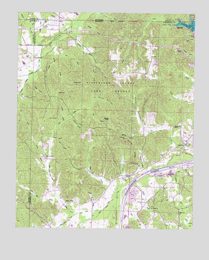
Doskie, MS USGS Topographic Map
Click on map above to begin viewing in our Map Viewer.

This topographic map contains these locations and features:
Feature Name Type Latitude Longitude GNIS ID View Map
Barnes Chapel School (historical)SchoolN34.9240°W88.2842°689859View Map
Barnes HollowValleyN34.9318°W88.2870°666531View Map
Beaver Pond (historical)LakeN34.9748°W88.3625°689866View Map
Bethel CemeteryCemeteryN34.8881°W88.2798°689871View Map
Bethel ChurchChurchN34.8870°W88.2789°666960View Map
Bethel SchoolSchoolN34.8773°W88.2825°666966View Map
Bethel School (historical)SchoolN34.8876°W88.2784°689872View Map
Bingham School (historical)SchoolN34.9740°W88.3095°689874View Map
Blackard CemeteryCemeteryN34.9537°W88.3459°667239View Map
Blue Bill SpringSpringN34.9389°W88.3101°667282View Map
Calahan BranchStreamN34.9923°W88.3375°667912View Map
Caney CreekStreamN34.8854°W88.3139°668038View Map
Caney Creek Drainage DitchCanalN34.9001°W88.3495°689888View Map
Caroline BranchStreamN34.9076°W88.3512°668078View Map
Center Point SchoolSchoolN34.9223°W88.3559°668246View Map
Chalybeate SpringSpringN34.9935°W88.2668°668298View Map
Chamber Creek Drainage DitchCanalN34.9809°W88.3737°689892View Map
Cochrane BranchStreamN34.9023°W88.2909°668639View Map
Coke CreekStreamN34.8837°W88.3309°668648View Map
Cold Mill CreekStreamN34.9151°W88.2553°668657View Map
Coln BranchStreamN34.9834°W88.3487°668709View Map
Copperas BranchStreamN34.9365°W88.3417°668823View Map
Counts BranchStreamN34.8815°W88.2567°668863View Map
Cross RoadsPopulated PlaceN34.9243°W88.2559°668967View Map
DoskiePopulated PlaceN34.9059°W88.2950°669338View Map
Fairview ChurchChurchN34.9790°W88.2623°669894View Map
Fairview School (historical)SchoolN34.9801°W88.2612°689904View Map
Foote BranchStreamN34.8879°W88.2992°670070View Map
Gray HollowValleyN34.9450°W88.3233°670631View Map
Grays Box (historical)LocaleN34.9176°W88.3334°689917View Map
Greenhaw BranchStreamN34.9637°W88.3673°670693View Map
Grissom ChapelChurchN34.8898°W88.3398°670751View Map
Happy HollowValleyN34.9323°W88.2853°670889View Map
Haynes BranchStreamN34.9793°W88.3517°671027View Map
Hepsibah School (historical)SchoolN34.9245°W88.2570°689920View Map
Hill BranchStreamN34.9448°W88.3231°671206View Map
Hogue BranchStreamN34.9270°W88.3500°671273View Map
Johnson BranchStreamN34.8851°W88.3209°671918View Map
Johnson CemeteryCemeteryN34.8915°W88.3195°671928View Map
Lambs Chapel CemeteryCemeteryN34.9387°W88.3467°672285View Map
Lambs Chapel School (historical)SchoolN34.9506°W88.3470°689935View Map
Leitch Mill BranchStreamN34.8887°W88.3417°672399View Map
Little Yellow CreekStreamN34.8998°W88.2939°672714View Map
Long BranchStreamN34.9265°W88.3459°672801View Map
Marlar BranchStreamN34.9809°W88.3525°673141View Map
Mayo BranchStreamN34.8951°W88.3037°673274View Map
McMinn BranchStreamN34.9920°W88.3312°673406View Map
Morris CemeteryCemeteryN34.9967°W88.2661°1294410View Map
Moser BranchStreamN34.9112°W88.2598°673863View Map
Moser BridgeBridgeN34.9006°W88.2931°673864View Map
Mulberry CemeteryCemeteryN34.8987°W88.3131°689949View Map
Mulberry SchoolSchoolN34.8981°W88.3131°674460View Map
Mulberry School (historical)SchoolN34.8979°W88.3131°689950View Map
North Cross Roads CemeteryCemeteryN34.9212°W88.2567°689953View Map
North Crossroads Fire DepartmentBuildingN34.9287°W88.2592°2666071View Map
Oak Hill BranchStreamN34.9894°W88.3667°675073View Map
Oak Hill ChurchChurchN34.9948°W88.3650°675084View Map
Old Pleasant Hill CemeteryCemeteryN34.9354°W88.2639°689955View Map
Pig BranchStreamN34.9704°W88.3212°675723View Map
Pine BranchStreamN34.9393°W88.3375°675800View Map
Pine FlatPopulated PlaceN34.9743°W88.2800°692142View Map
Pleasant Grove CemeteryCemeteryN34.9131°W88.2889°689962View Map
Pleasant Grove ChurchChurchN34.9129°W88.2881°676049View Map
Pleasant Hill ChurchChurchN34.9348°W88.2637°676086View Map
Robinson CreekStreamN34.9129°W88.2606°676732View Map
Salem CemeteryCemeteryN34.8840°W88.2592°689977View Map
Salem ChurchChurchN34.8845°W88.2589°677293View Map
Sandy Creek SubdivisionPopulated PlaceN34.9923°W88.2573°677387View Map
Scotch HillSummitN34.9590°W88.3295°677461View Map
Sevenmile CreekStreamN34.9806°W88.3550°677528View Map
Sevenmile CreekStreamN34.9806°W88.3550°1301105View Map
Shady Grove CemeteryCemeteryN34.9162°W88.3559°689981View Map
Shady Grove ChurchChurchN34.9156°W88.3556°677599View Map
Shady Grove Church (historical)ChurchN34.9245°W88.3703°683204View Map
Sharp BridgeBridgeN34.9879°W88.3437°677621View Map
Slab BranchStreamN34.9515°W88.3737°677873View Map
Supervisor District 2CivilN34.8871°W88.3079°712101View Map
Tishomingo County Game RefugeParkN34.9573°W88.3098°678782View Map
Union ChurchChurchN34.9218°W88.2578°679068View Map
Utley BranchStreamN34.9720°W88.3498°679164View Map
Waldrop CreekStreamN34.9854°W88.3475°679253View Map
Waldrop CreekStreamN34.9851°W88.3473°1304327View Map
Wardlow BranchStreamN34.9923°W88.3317°679337View Map
Wayne BranchStreamN34.9851°W88.3523°1273958View Map
Wayne BranchStreamN34.9854°W88.3525°679399View Map
Welch BranchStreamN34.9048°W88.2881°679429View Map
Woodruff BranchStreamN34.9081°W88.2823°679860View Map
Yankee Charlie RidgeRidgeN34.9229°W88.2925°679913View Map

Note: Coordinates in the location and feature list above are referenced to NAD83 datum.


Copyright (C) 2008-2025 Ryan Niemi / Sunset Dynamics ... All Rights Reserved