TopoQuest Logo
Do you find TopoQuest useful?
Help keep TopoQuest running and adding new maps/features by donating!
Bitcoin:  19c7KJd3qBynnjoSw5npx9KScwjBe4ifkT
Litecoin:  LXs6TkuXGGXo1vDsWCkWVdjQX94eUKd6ui
Home View Maps Find Maps Find Places Resources & Links


Fondaway Canyon, Nevada Topographic Map

USGS Map Title: Fondaway Canyon, NV
USGS Map MRC: 39118G2
DRG (GeoTIFF) Download: o39118g2.tif


Neighboring USGS Topographic Map Quads:


  Lone Rock, NV  
39118H3
 

  Buena Vista Hills South, NV  
39118H2
 

  Dixie Hot Springs NE, NV  
39118H1
 

  Lone Rock SE, NV  
39118G3
 

  Fondaway Canyon, NV  
39118G2
 

  Dixie Hot Springs, NV  
39118G1
 

  Cox Canyon, NV  
39118F3
 

  I X L Canyon, NV  
39118F2
 

  Dixie Valley, NV  
39118F1


Map MRC Location:

N40°
W119°
N40°
W118°
H8 H7 H6 H5 H4 H3 H2 H1
G8 G7 G6 G5 G4 G3 G2 G1
F8 F7 F6 F5 F4 F3 F2 F1
E8 E7 E6 E5 E4 E3 E2 E1
D8 D7 D6 D5 D4 D3 D2 D1
C8 C7 C6 C5 C4 C3 C2 C1
B8 B7 B6 B5 B4 B3 B2 B1
A8 A7 A6 A5 A4 A3 A2 A1
N39°
W119°
N39°
W118°

Fondaway Canyon, NV USGS 1:24K Topographic Map Preview:
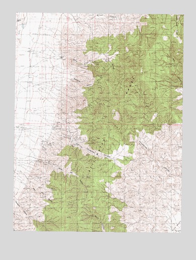
Fondaway Canyon, NV USGS Topographic Map
Click on map above to begin viewing in our Map Viewer.

This topographic map contains these locations and features:
Feature Name Type Latitude Longitude GNIS ID View Map
Big Elk CanyonValleyN39.7755°W118.2415°838738View Map
Coppereid (historical)Populated PlaceN39.8488°W118.2190°856002View Map
Coppereid Post Office (historical)Post OfficeN39.8488°W118.2190°864687View Map
Fondaway CanyonValleyN39.8077°W118.2218°863998View Map
Fork Fondaway CanyonValleyN39.7999°W118.2032°847597View Map
Home Station (historical)LocaleN39.8082°W118.2443°847636View Map
Pike HollowBasinN39.7938°W118.1732°848323View Map
Quick Tung Quicksilver MineMineN39.7882°W118.2260°855609View Map
Quik Tung MineMineN39.8041°W118.2049°854957View Map
Shady Run (historical)LocaleN39.7894°W118.2332°847630View Map
Shady Run CanyonValleyN39.7913°W118.2340°843588View Map
Shady Run Mining DistrictCivilN39.7805°W118.2176°856557View Map
Shamrock CanyonValleyN39.8369°W118.2099°843601View Map
Shanghai CanyonValleyN39.7669°W118.2479°843604View Map
Shanghai SpringSpringN39.7594°W118.2371°847615View Map
Silver Range MineMineN39.8041°W118.2049°843712View Map
White Cloud CanyonValleyN39.8482°W118.2162°844768View Map
White Cloud Mining DistrictCivilN39.8471°W118.1860°856559View Map

Note: Coordinates in the location and feature list above are referenced to NAD83 datum.


Copyright (C) 2008-2025 Ryan Niemi / Sunset Dynamics ... All Rights Reserved