TopoQuest Logo
Do you find TopoQuest useful?
Help keep TopoQuest running and adding new maps/features by donating!
Bitcoin:  19c7KJd3qBynnjoSw5npx9KScwjBe4ifkT
Litecoin:  LXs6TkuXGGXo1vDsWCkWVdjQX94eUKd6ui
Home View Maps Find Maps Find Places Resources & Links


Crane Creek, Oregon Topographic Map

USGS Map Title: Crane Creek, OR
USGS Map MRC: 42120A3
DRG (GeoTIFF) Download: o42120a3.tif


Neighboring USGS Topographic Map Quads:


  Lakeview Airport, OR  
42120B4
 

  Lakeview, OR  
42120B3
 

  Horse Prairie, OR  
42120B2
 

  West Side, OR  
42120A4
 

  Crane Creek, OR  
42120A3
 

  Crane Mountain, OR  
42120A2
 

  West of Willow Ranch, CA  
41120H4
 

  Willow Ranch, CA  
41120H3
 

  Mount Bidwell, CA  
41120H2


Map MRC Location:

N43°
W121°
N43°
W120°
H8 H7 H6 H5 H4 H3 H2 H1
G8 G7 G6 G5 G4 G3 G2 G1
F8 F7 F6 F5 F4 F3 F2 F1
E8 E7 E6 E5 E4 E3 E2 E1
D8 D7 D6 D5 D4 D3 D2 D1
C8 C7 C6 C5 C4 C3 C2 C1
B8 B7 B6 B5 B4 B3 B2 B1
A8 A7 A6 A5 A4 A3 A2 A1
N42°
W121°
N42°
W120°

Crane Creek, OR USGS 1:24K Topographic Map Preview:
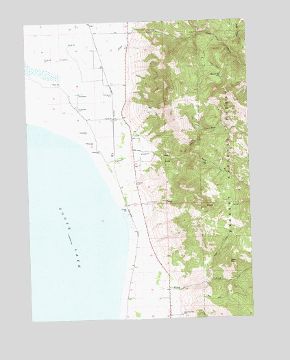
Crane Creek, OR USGS Topographic Map
Click on map above to begin viewing in our Map Viewer.

This topographic map contains these locations and features:
Feature Name Type Latitude Longitude GNIS ID View Map
Church CreekStreamN42.0999°W120.3177°1153730View Map
Cogswell CreekStreamN42.0660°W120.3388°1139904View Map
Crane CreekStreamN42.1071°W120.3372°1140372View Map
Deter RanchLocaleN42.0838°W120.3277°1639097View Map
Duke CreekStreamN42.0957°W120.3163°1153729View Map
Fisher RanchLocaleN42.0082°W120.3036°1155836View Map
Goose Lake Post Office (historical)Post OfficeN42.1068°W120.3191°1164381View Map
Hot Springs (historical)Populated PlaceN42.1068°W120.3191°1153733View Map
Hot Springs Post Office (historical)Post OfficeN42.1068°W120.3191°1165415View Map
Kelley CreekStreamN42.0154°W120.3233°1144519View Map
New Pine Creek CemeteryCemeteryN42.0021°W120.2908°1146803View Map
New Pine Creek Census Designated PlaceCensusN42.0014°W120.3043°2612515View Map
North Fork Cogswell CreekStreamN42.0702°W120.3000°1146932View Map
North Fork Crane CreekStreamN42.1152°W120.2633°1146936View Map
Sherlock RanchLocaleN42.1088°W120.3194°1639096View Map
Snelling (historical)LocaleN42.0685°W120.3269°1167025View Map
Snider RanchLocaleN42.0927°W120.3202°1155835View Map
South Fork Cogswell CreekStreamN42.0699°W120.2997°1149955View Map
Sugar CreekStreamN42.0163°W120.2733°1150526View Map
Sugar PeakSummitN42.0232°W120.2636°1150536View Map
Tandy CreekStreamN42.0463°W120.3241°1150886View Map
Thomas (historical)LocaleN42.0666°W120.3483°1153731View Map
Thunder Egg LakeLakeN42.1014°W120.2656°1151202View Map
Vernon RanchLocaleN42.1207°W120.3175°1155834View Map
Wendell (historical)LocaleN42.0846°W120.3261°1153732View Map

Note: Coordinates in the location and feature list above are referenced to NAD83 datum.


Copyright (C) 2008-2025 Ryan Niemi / Sunset Dynamics ... All Rights Reserved