TopoQuest Logo
Do you find TopoQuest useful?
Help keep TopoQuest running and adding new maps/features by donating!
Bitcoin:  19c7KJd3qBynnjoSw5npx9KScwjBe4ifkT
Litecoin:  LXs6TkuXGGXo1vDsWCkWVdjQX94eUKd6ui
Home View Maps Find Maps Find Places Resources & Links


Crawfordsville, Oregon Topographic Map

USGS Map Title: Crawfordsville, OR
USGS Map MRC: 44122C7
DRG (GeoTIFF) Download: o44122c7.tif


Neighboring USGS Topographic Map Quads:


  Brownsville, OR  
44122D8
 

  Waterloo, OR  
44122D7
 

  Sweet Home, OR  
44122D6
 

  Union Point, OR  
44122C8
 

  Crawfordsville, OR  
44122C7
 

  Chandler Mountain, OR  
44122C6
 

  Mohawk, OR  
44122B8
 

  Marcola, OR  
44122B7
 

  Mount Nebo, OR  
44122B6


Map MRC Location:

N45°
W123°
N45°
W122°
H8 H7 H6 H5 H4 H3 H2 H1
G8 G7 G6 G5 G4 G3 G2 G1
F8 F7 F6 F5 F4 F3 F2 F1
E8 E7 E6 E5 E4 E3 E2 E1
D8 D7 D6 D5 D4 D3 D2 D1
C8 C7 C6 C5 C4 C3 C2 C1
B8 B7 B6 B5 B4 B3 B2 B1
A8 A7 A6 A5 A4 A3 A2 A1
N44°
W123°
N44°
W122°

Crawfordsville, OR USGS 1:24K Topographic Map Preview:
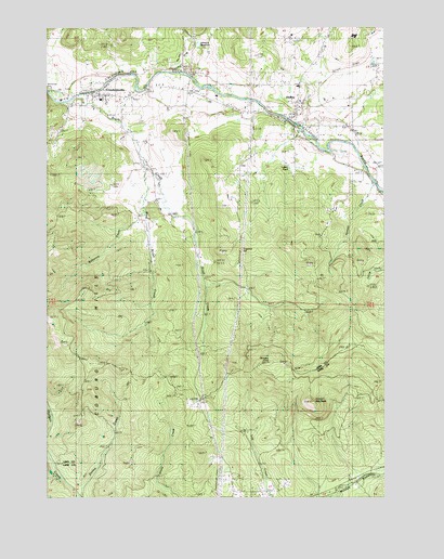
Crawfordsville, OR USGS Topographic Map
Click on map above to begin viewing in our Map Viewer.

This topographic map contains these locations and features:
Feature Name Type Latitude Longitude GNIS ID View Map
Bickmore CreekStreamN44.3262°W122.8415°1130594View Map
Brush CreekStreamN44.3548°W122.8701°1118150View Map
CrawfordsvillePopulated PlaceN44.3571°W122.8579°1119522View Map
Crawfordsville BridgeBridgeN44.3568°W122.8609°1162194View Map
Crawfordsville Census Designated PlaceCensusN44.3561°W122.8649°2584413View Map
Crawfordsville Elementary SchoolSchoolN44.3558°W122.8561°2466031View Map
Crawfordsville Post OfficePost OfficeN44.3573°W122.8558°1165104View Map
Crawfordsville Union CemeteryCemeteryN44.3500°W122.8408°1130622View Map
Crescent HillSummitN44.3157°W122.8051°1136191View Map
Ernests PondLakeN44.2790°W122.7790°1130630View Map
Georges KnobSummitN44.2857°W122.7934°1136313View Map
Grassy MountainSummitN44.2753°W122.7782°1121313View Map
HolleyPopulated PlaceN44.3543°W122.7834°1121920View Map
Holley Census Designated PlaceCensusN44.3490°W122.7856°2584416View Map
Holley Elementary SchoolSchoolN44.3593°W122.7827°2466076View Map
Holley Post Office (historical)Post OfficeN44.3543°W122.7834°1165403View Map
Independent Order of Odd Fellows CemeteryCemeteryN44.3576°W122.8683°1162196View Map
Johnson CreekStreamN44.3612°W122.8212°1159063View Map
Johnson ReservoirReservoirN44.3703°W122.8200°1133223View Map
Lutton PondLakeN44.3418°W122.7862°1133222View Map
Matlock BridgeBridgeN44.3498°W122.7845°1162198View Map
McClun Wayside County ParkParkN44.3337°W122.7562°1966248View Map
Noble SpringSpringN44.3651°W122.7804°1130593View Map
Sawyer CreekStreamN44.3332°W122.7540°1130629View Map
Sweet Home Fire and Ambulance District Station 23BuildingN44.3549°W122.8551°2576917View Map
West Brush CreekStreamN44.3382°W122.8401°1128814View Map

Note: Coordinates in the location and feature list above are referenced to NAD83 datum.


Copyright (C) 2008-2025 Ryan Niemi / Sunset Dynamics ... All Rights Reserved