TopoQuest Logo
Do you find TopoQuest useful?
Help keep TopoQuest running and adding new maps/features by donating!
Bitcoin:  19c7KJd3qBynnjoSw5npx9KScwjBe4ifkT
Litecoin:  LXs6TkuXGGXo1vDsWCkWVdjQX94eUKd6ui
Home View Maps Find Maps Find Places Resources & Links


Creeds, Virginia Topographic Map

USGS Map Title: Creeds, VA
USGS Map MRC: 36076E1
DRG (GeoTIFF) Download: o36076e1.tif


Neighboring USGS Topographic Map Quads:


  Fentress, VA  
36076F2
 

  Pleasant Ridge, VA  
36076F1
 

  North Bay, VA  
36075F8
 

  Moyock, NC  
36076E2
 

  Creeds, VA  
36076E1
 

  Knotts Island, NC  
36075E8
 

  Lambs Corner, NC  
36076D2
 

  Currituck, NC  
36076D1
 

  Barco, NC  
36075D8


Map MRC Location:

N37°
W77°
N37°
W76°
H8 H7 H6 H5 H4 H3 H2 H1
G8 G7 G6 G5 G4 G3 G2 G1
F8 F7 F6 F5 F4 F3 F2 F1
E8 E7 E6 E5 E4 E3 E2 E1
D8 D7 D6 D5 D4 D3 D2 D1
C8 C7 C6 C5 C4 C3 C2 C1
B8 B7 B6 B5 B4 B3 B2 B1
A8 A7 A6 A5 A4 A3 A2 A1
N36°
W77°
N36°
W76°

Creeds, VA USGS 1:24K Topographic Map Preview:
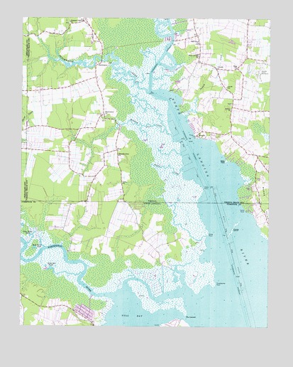
Creeds, VA USGS Topographic Map
Click on map above to begin viewing in our Map Viewer.

This topographic map contains these locations and features:
Feature Name Type Latitude Longitude GNIS ID View Map
Bethel CemeteryCemeteryN36.5904°W76.0185°1478191View Map
Bethel ChurchChurchN36.5879°W76.0191°1478193View Map
BlackwaterPopulated PlaceN36.6060°W76.0866°1492587View Map
Blackwater CemeteryCemeteryN36.5857°W76.0822°1780195View Map
Blackwater ChurchChurchN36.5857°W76.0827°1478227View Map
Blackwater CreekStreamN36.5946°W76.0599°1478229View Map
Buck Island PondLakeN36.5318°W76.1175°982110View Map
Cava ChurchChurchN36.5577°W76.0735°1478340View Map
CreedsPopulated PlaceN36.6049°W76.0263°1492820View Map
Creeds Field (historical)AirportN36.6050°W76.0078°2092479View Map
Creeds HeliportAirportN36.6049°W76.0044°1501675View Map
Creeds SchoolSchoolN36.5971°W76.0216°1478442View Map
Faraby IslandIslandN36.5399°W76.0180°1020215View Map
Gibbs PointCapeN36.5374°W76.0302°985662View Map
Gibbs WoodsWoodsN36.5354°W76.0463°1002457View Map
Green PointCapeN36.5560°W76.0324°1478693View Map
GreentownPopulated PlaceN36.5007°W76.0872°1018668View Map
Hog IslandIslandN36.5113°W76.0288°1002491View Map
Kala ChurchChurchN36.6049°W76.0160°1478877View Map
Knight's Landing LLC Airport (historical)AirportN36.5601°W76.1194°2675634View Map
Milldam CreekStreamN36.5774°W76.0483°1479099View Map
MundenPopulated PlaceN36.5779°W76.0358°1493329View Map
Munden PointCapeN36.5779°W76.0360°1488879View Map
Nellie Bell PondsLakeN36.5233°W76.1097°990903View Map
Northwest RiverStreamN36.5121°W76.0747°1025587View Map
Oak Grove Baptist ChurchChurchN36.6149°W76.0349°1479233View Map
Oak Grove CemeteryCemeteryN36.6145°W76.0359°1780206View Map
Oakum CreekStreamN36.5857°W76.0416°1479245View Map
Peter Dozier PondLakeN36.5368°W76.1197°992081View Map
Piney Grove ChurchChurchN36.6099°W76.0352°1479330View Map
Pleasant Valley ChurchChurchN36.6232°W76.1005°1479349View Map
Princess Anne ChurchChurchN36.5693°W76.0758°1479384View Map
Pungo FerryPopulated PlaceN36.6154°W76.0463°1488862View Map
Pungo Ferry MarinaHarborN36.6181°W76.0466°2520113View Map
Sandy PointCapeN36.5463°W76.0124°994305View Map
Slab Landing (historical)LocaleN36.5302°W76.1013°1002409View Map
Snake CreekStreamN36.5699°W76.0444°1496455View Map
The LaunchChannelN36.5038°W76.0419°995985View Map
Troublesome PointCapeN36.5179°W76.0260°996267View Map
Tull BayBayN36.5029°W76.0674°996304View Map
VinePopulated PlaceN36.5715°W76.0766°1479796View Map
Virginia Beach Fire Department Station 13 BlackwaterBuildingN36.5849°W76.0833°2090090View Map
Virginia Beach Fire Department Station 6 CreedsBuildingN36.6035°W76.0268°2090092View Map
Walke PointCapeN36.5668°W76.0216°1479809View Map
Walnut CreekStreamN36.5643°W76.0427°1479815View Map

Note: Coordinates in the location and feature list above are referenced to NAD83 datum.


Copyright (C) 2008-2025 Ryan Niemi / Sunset Dynamics ... All Rights Reserved