TopoQuest Logo
Do you find TopoQuest useful?
Help keep TopoQuest running and adding new maps/features by donating!
Bitcoin:  19c7KJd3qBynnjoSw5npx9KScwjBe4ifkT
Litecoin:  LXs6TkuXGGXo1vDsWCkWVdjQX94eUKd6ui
Home View Maps Find Maps Find Places Resources & Links


Pleasant Ridge, Virginia Topographic Map

USGS Map Title: Pleasant Ridge, VA
USGS Map MRC: 36076F1
DRG (GeoTIFF) Download: o36076f1.tif


Neighboring USGS Topographic Map Quads:


  Kempsville, VA  
36076G2
 

  Princess Anne, VA  
36076G1
 

  Virginia Beach, VA  
36075G8
 

  Fentress, VA  
36076F2
 

  Pleasant Ridge, VA  
36076F1
 

  North Bay, VA  
36075F8
 

  Moyock, NC  
36076E2
 

  Creeds, VA  
36076E1
 

  Knotts Island, NC  
36075E8


Map MRC Location:

N37°
W77°
N37°
W76°
H8 H7 H6 H5 H4 H3 H2 H1
G8 G7 G6 G5 G4 G3 G2 G1
F8 F7 F6 F5 F4 F3 F2 F1
E8 E7 E6 E5 E4 E3 E2 E1
D8 D7 D6 D5 D4 D3 D2 D1
C8 C7 C6 C5 C4 C3 C2 C1
B8 B7 B6 B5 B4 B3 B2 B1
A8 A7 A6 A5 A4 A3 A2 A1
N36°
W77°
N36°
W76°

Pleasant Ridge, VA USGS 1:24K Topographic Map Preview:
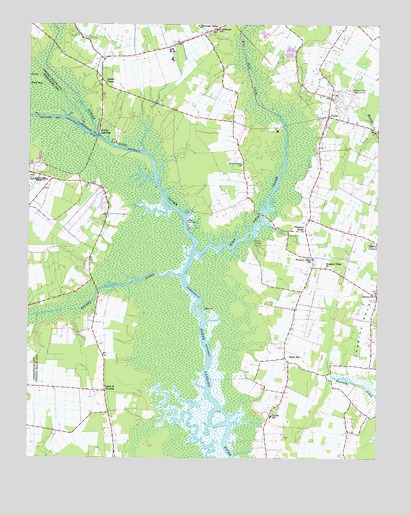
Pleasant Ridge, VA USGS Topographic Map
Click on map above to begin viewing in our Map Viewer.

This topographic map contains these locations and features:
Feature Name Type Latitude Longitude GNIS ID View Map
Asbury Methodist ChurchChurchN36.6828°W76.0228°2092428View Map
Back BayLocaleN36.6540°W76.0324°1478121View Map
Backbay Post OfficePost OfficeN36.6551°W76.0331°1780192View Map
Beech Grove ChurchChurchN36.7096°W76.0480°1478168View Map
Bonney LandingLocaleN36.6865°W76.0438°1496810View Map
Camels ChapelChurchN36.7332°W76.0974°1478309View Map
Charity United Methodist Church CemeteryCemeteryN36.6728°W76.0012°1780197View Map
Christ Unity Oceanside ChurchChurchN36.7222°W76.0075°2520229View Map
Christian Chapel Assembly of God ChurchChurchN36.7435°W76.1039°2520231View Map
City HeliportAirportN36.7460°W76.0524°1501671View Map
Court House Elementary SchoolSchoolN36.7482°W76.0574°1478430View Map
Cow CreekStreamN36.7049°W76.0802°1488864View Map
Creeds Elementary SchoolSchoolN36.6373°W76.0376°1478443View Map
Dawley CornersPopulated PlaceN36.6871°W76.0002°1496871View Map
Floyd E Kellam High SchoolSchoolN36.7431°W76.0626°1478604View Map
Haynes CreekStreamN36.7054°W76.0788°1488861View Map
Heron Ridge Golf ClubLocaleN36.7332°W76.0336°2520166View Map
Hope Haven Adult HomeBuildingN36.7430°W76.0742°2520007View Map
Land of PromiseLocaleN36.6443°W76.0969°1478920View Map
Military Aviation MuseumBuildingN36.6789°W76.0282°2520519View Map
North LandingPopulated PlaceN36.7185°W76.0997°1497053View Map
North Landing Elementary SchoolSchoolN36.7401°W76.0735°1780205View Map
Pleasant RidgeLocaleN36.6907°W76.0252°1479345View Map
Pleasant Ridge ChurchChurchN36.6802°W76.0183°1479346View Map
Pleasant Ridge School (historical)SchoolN36.6827°W76.0227°1479347View Map
Pocaty RiverStreamN36.6779°W76.0699°1479355View Map
Princess Anne Middle SchoolSchoolN36.7495°W76.0343°1780208View Map
PungoPopulated PlaceN36.7235°W76.0177°1497109View Map
Pungo Field (historical)AirportN36.7281°W76.0114°2092519View Map
Red Mill Elementary SchoolSchoolN36.7477°W76.0000°1780209View Map
Saint John the Apostle Catholic SchoolSchoolN36.7496°W76.0054°2519545View Map
Signature at West Neck Golf CourseLocaleN36.7318°W76.0641°2520199View Map
Technical and Career Educational CenterSchoolN36.7427°W76.0741°2465267View Map
Tidewater United Church of ChristChurchN36.7454°W76.0596°2519848View Map
Virginia Beach AirportAirportN36.6788°W76.0307°2675637View Map
Virginia Beach Police AviationBuildingN36.7466°W76.0420°2332065View Map
Virginia Beach Public Library-Pungo-Backwater Area LibraryBuildingN36.6371°W76.0374°2056791View Map
Virginia Beach Public Library-Pungo-Backwater Area LibraryBuildingN36.6371°W76.0374°2057334View Map
Virginia Beach Sheriff's OfficeBuildingN36.7461°W76.0405°2331945View Map
West LandingLocaleN36.6921°W76.0669°1497203View Map
West Neck CreekStreamN36.6843°W76.0647°1479850View Map
West Neck MarinaHarborN36.6917°W76.0370°2520124View Map

Note: Coordinates in the location and feature list above are referenced to NAD83 datum.


Copyright (C) 2008-2024 Ryan Niemi / Sunset Dynamics ... All Rights Reserved