TopoQuest Logo
Do you find TopoQuest useful?
Help keep TopoQuest running and adding new maps/features by donating!
Bitcoin:  19c7KJd3qBynnjoSw5npx9KScwjBe4ifkT
Litecoin:  LXs6TkuXGGXo1vDsWCkWVdjQX94eUKd6ui
Home View Maps Find Maps Find Places Resources & Links


Knotts Island, North Carolina Topographic Map

USGS Map Title: Knotts Island, NC
USGS Map MRC: 36075E8
DRG (GeoTIFF) Download: o36075e8.tif


Neighboring USGS Topographic Map Quads:


  Pleasant Ridge, VA  
36076F1
 

  North Bay, VA  
36075F8


  Creeds, VA  
36076E1
 

  Knotts Island, NC  
36075E8


  Currituck, NC  
36076D1
 

  Barco, NC  
36075D8


Map MRC Location:

N37°
W76°
N37°
W75°
H8 H7 H6 H5 H4 H3 H2 H1
G8 G7 G6 G5 G4 G3 G2 G1
F8 F7 F6 F5 F4 F3 F2 F1
E8 E7 E6 E5 E4 E3 E2 E1
D8 D7 D6 D5 D4 D3 D2 D1
C8 C7 C6 C5 C4 C3 C2 C1
B8 B7 B6 B5 B4 B3 B2 B1
A8 A7 A6 A5 A4 A3 A2 A1
N36°
W76°
N36°
W75°

Knotts Island, NC USGS 1:24K Topographic Map Preview:
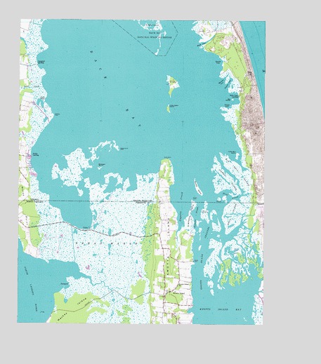
Knotts Island, NC USGS Topographic Map
Click on map above to begin viewing in our Map Viewer.

This topographic map contains these locations and features:
Feature Name Type Latitude Longitude GNIS ID View Map
Back BayBayN36.6002°W75.9663°1478120View Map
Back CreekBayN36.5179°W75.9627°1002492View Map
Barbours Hill Waterfowl Management AreaParkN36.5946°W75.8830°1780193View Map
Big Ball IslandIslandN36.5624°W75.8874°1478207View Map
Big IslandIslandN36.5924°W75.8910°1478211View Map
Big Perch IslandIslandN36.5365°W75.8974°2040089View Map
Buckle IslandIslandN36.5557°W75.9080°1930511View Map
Campbells LandingPopulated PlaceN36.6068°W75.9910°1495348View Map
Capsies CreekStreamN36.5621°W75.9144°982643View Map
Carol PondReservoirN36.5917°W75.9890°1478326View Map
Cason PointCapeN36.5263°W75.9102°982732View Map
Cedar IslandIslandN36.5985°W75.9213°1478351View Map
CorysPopulated PlaceN36.5388°W75.9633°1019796View Map
Cowpen CoveBayN36.5990°W75.8930°1478434View Map
Deal CreekBayN36.5527°W75.8921°1502000View Map
Deal IslandIslandN36.5457°W75.8913°1025279View Map
Devil CreekStreamN36.5974°W75.9877°1478484View Map
False CapeLocaleN36.6027°W75.8841°1478585View Map
False Cape Coast Guard Station (historical)MilitaryN36.6019°W75.8811°1780199View Map
False Cape LandingPopulated PlaceN36.5943°W75.8877°1495528View Map
False Cape State ParkParkN36.5877°W75.8841°1780200View Map
Ferguson Mobile Home ParkPopulated PlaceN36.5185°W75.9243°2505471View Map
Great MarshSwampN36.5266°W75.9509°1025351View Map
Hammet CoveBayN36.6004°W75.8955°1478716View Map
Hammock IslandIslandN36.5385°W75.9069°2040090View Map
Hemsath Mobile Home ParkPopulated PlaceN36.5060°W75.9242°2505599View Map
Horse IslandIslandN36.5604°W75.8930°1478790View Map
Knight PointCapeN36.5515°W75.9116°1478900View Map
Knotts IslandIslandN36.5324°W75.9230°1025459View Map
Knotts IslandPopulated PlaceN36.5135°W75.9191°1026300View Map
Knotts Island Baptist ChurchChurchN36.5154°W75.9174°988056View Map
Knotts Island BayBayN36.5035°W75.8955°988054View Map
Knotts Island ChannelChannelN36.5302°W75.9052°988055View Map
Knotts Island Community CenterBuildingN36.5140°W75.9194°2056430View Map
Knotts Island Elementary SchoolSchoolN36.5133°W75.9203°1002451View Map
Knotts Island Post OfficePost OfficeN36.5296°W75.9246°2056429View Map
Knotts Island Post OfficePost OfficeN36.5299°W75.9251°2774177View Map
Knotts Island Rescue SquadBuildingN36.5076°W75.9252°2720359View Map
Knotts Island Ruritan ParkParkN36.5086°W75.9174°2076394View Map
Knotts Island United Methodist ChurchChurchN36.5118°W75.9244°2056431View Map
Knotts Island Volunteer Fire DepartmentBuildingN36.5075°W75.9250°2056432View Map
Little Ball IslandIslandN36.5699°W75.8885°1478964View Map
Little Cedar IslandIslandN36.5888°W75.9235°1478966View Map
Little Perch IslandIslandN36.5377°W75.9010°2040088View Map
Mackay IslandIslandN36.5060°W75.9716°989211View Map
Mackay Island National Wildlife RefugeParkN36.5245°W75.9558°1026282View Map
Man IslandIslandN36.5460°W75.9052°1478286View Map
Manns IslandIslandN36.5418°W75.8996°2044408View Map
Mon IslandIslandN36.5457°W75.9049°1025554View Map
Morse PointCapeN36.5474°W75.9960°1025559View Map
North End (historical)Populated PlaceN36.5671°W75.9241°1780204View Map
North End SchoolSchoolN36.5318°W75.9271°1002454View Map
Pellitory PointCapeN36.5857°W75.9821°1479310View Map
Pocahontas Waterfowl Management AreaParkN36.5660°W75.9685°1780207View Map
Porpoise SloughStreamN36.5446°W75.9094°1025624View Map
Porpoise SloughGutN36.5446°W75.9094°1502098View Map
Public LandingPopulated PlaceN36.5690°W75.9935°1496118View Map
Sedge Island PointCapeN36.5715°W75.9485°1479566View Map
Simon IslandIslandN36.5521°W75.8952°1027627View Map
Simpson IslandIslandN36.5640°W75.9583°1479626View Map
Simpson NeckCapeN36.5457°W75.9124°1025701View Map
Smith IslandIslandN36.5418°W75.9080°2040092View Map
South Buckle IslandIslandN36.5456°W75.9053°2090003View Map
South InletGutN36.6152°W75.9069°1479648View Map
Spratts CoveBayN36.6079°W75.8971°1479666View Map
Tripps CoveBayN36.5893°W75.8933°1479763View Map
Trojan Waterfowl Management AreaParkN36.5860°W75.9863°1780214View Map
WoodleighLocaleN36.5260°W75.9183°1002455View Map

Note: Coordinates in the location and feature list above are referenced to NAD83 datum.


Copyright (C) 2008-2024 Ryan Niemi / Sunset Dynamics ... All Rights Reserved