TopoQuest Logo
Do you find TopoQuest useful?
Help keep TopoQuest running and adding new maps/features by donating!
Bitcoin:  19c7KJd3qBynnjoSw5npx9KScwjBe4ifkT
Litecoin:  LXs6TkuXGGXo1vDsWCkWVdjQX94eUKd6ui
Home View Maps Find Maps Find Places Resources & Links


Crevison Peak, California Topographic Map

USGS Map Title: Crevison Peak, CA
USGS Map MRC: 37121B2
DRG (GeoTIFF) Download: o37121b2.tif


Neighboring USGS Topographic Map Quads:


  Wilcox Ridge, CA  
37121C3
 

  Orestimba Peak, CA  
37121C2
 

  Newman, CA  
37121C1
 

  Mustang Peak, CA  
37121B3
 

  Crevison Peak, CA  
37121B2
 

  Howard Ranch, CA  
37121B1
 

  Pacheco Peak, CA  
37121A3
 

  Pacheco Pass, CA  
37121A2
 

  San Luis Dam, CA  
37121A1


Map MRC Location:

N38°
W122°
N38°
W121°
H8 H7 H6 H5 H4 H3 H2 H1
G8 G7 G6 G5 G4 G3 G2 G1
F8 F7 F6 F5 F4 F3 F2 F1
E8 E7 E6 E5 E4 E3 E2 E1
D8 D7 D6 D5 D4 D3 D2 D1
C8 C7 C6 C5 C4 C3 C2 C1
B8 B7 B6 B5 B4 B3 B2 B1
A8 A7 A6 A5 A4 A3 A2 A1
N37°
W122°
N37°
W121°

Crevison Peak, CA USGS 1:24K Topographic Map Preview:
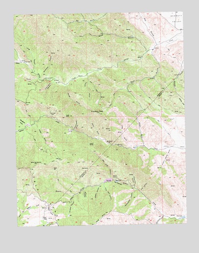
Crevison Peak, CA USGS Topographic Map
Click on map above to begin viewing in our Map Viewer.

This topographic map contains these locations and features:
Feature Name Type Latitude Longitude GNIS ID View Map
Bald Eagle MineMineN37.1902°W121.2233°218567View Map
Bass LakeReservoirN37.1505°W121.1773°218722View Map
Bear GulchValleyN37.2263°W121.1488°218840View Map
Big Deer CanyonValleyN37.1455°W121.2016°219177View Map
Big Pine CanyonValleyN37.1533°W121.1816°219228View Map
Big SpringSpringN37.1584°W121.2028°219259View Map
Bone Spring HillSummitN37.1622°W121.2358°219633View Map
Brown GulchValleyN37.1722°W121.1569°219888View Map
Cedar GulchValleyN37.1858°W121.2366°220780View Map
China Cabin FlatFlatN37.2111°W121.2252°221014View Map
Crevison PeakSummitN37.1911°W121.1888°221829View Map
Dry LakeLakeN37.1514°W121.1833°222649View Map
Eagle SpringSpringN37.1588°W121.2212°222836View Map
Eli HillSummitN37.1972°W121.2430°223093View Map
Fifield RanchLocaleN37.1294°W121.2324°223492View Map
Hawk RockPillarN37.1894°W121.2108°225032View Map
Indian Wells CanyonValleyN37.2099°W121.2224°225919View Map
Jeffers CanyonValleyN37.1474°W121.1902°226161View Map
Laurel SpringSpringN37.1726°W121.1968°226952View Map
Little Deer CanyonValleyN37.1491°W121.1863°227244View Map
Little Pine CanyonValleyN37.1477°W121.1641°227328View Map
Long CanyonValleyN37.2172°W121.2360°227542View Map
Long GulchValleyN37.1708°W121.1658°227558View Map
McDowell SpringSpringN37.1732°W121.1827°228353View Map
Mountain ValleyValleyN37.1808°W121.2072°229203View Map
Mule GulchValleyN37.2280°W121.1530°229306View Map
Oat GulchValleyN37.2324°W121.1469°229905View Map
Parnel CanyonValleyN37.2122°W121.1972°230376View Map
Reeves SpringSpringN37.1528°W121.1769°231476View Map
Richard CreekStreamN37.2227°W121.2452°234563View Map
Richey CampLocaleN37.2219°W121.2447°231548View Map
Rough GulchValleyN37.2069°W121.2124°231949View Map
Sulphur Spring GulchValleyN37.1694°W121.1374°235728View Map
Sycamore CanyonValleyN37.2133°W121.2277°235917View Map
The NarrowsGapN37.1497°W121.1744°236200View Map
Tile CanyonValleyN37.1444°W121.1588°236351View Map
Tule LakeReservoirN37.1287°W121.1290°236602View Map
Warm GulchValleyN37.1769°W121.1902°237239View Map
Williams CanyonValleyN37.1408°W121.2099°237842View Map
Woodchopper CanyonValleyN37.1452°W121.1638°238124View Map
Woodchopper GulchValleyN37.1819°W121.2072°238125View Map

Note: Coordinates in the location and feature list above are referenced to NAD83 datum.


Copyright (C) 2008-2025 Ryan Niemi / Sunset Dynamics ... All Rights Reserved