TopoQuest Logo
Do you find TopoQuest useful?
Help keep TopoQuest running and adding new maps/features by donating!
Bitcoin:  19c7KJd3qBynnjoSw5npx9KScwjBe4ifkT
Litecoin:  LXs6TkuXGGXo1vDsWCkWVdjQX94eUKd6ui
Home View Maps Find Maps Find Places Resources & Links


San Luis Dam, California Topographic Map

USGS Map Title: San Luis Dam, CA
USGS Map MRC: 37121A1
DRG (GeoTIFF) Download: o37121a1.tif


Neighboring USGS Topographic Map Quads:


  Crevison Peak, CA  
37121B2
 

  Howard Ranch, CA  
37121B1
 

  Ingomar, CA  
37120B8
 

  Pacheco Pass, CA  
37121A2
 

  San Luis Dam, CA  
37121A1
 

  Volta, CA  
37120A8
 

  Mariposa Peak, CA  
36121H2
 

  Los Banos Valley, CA  
36121H1
 

  Ortigalita Peak NW, CA  
36120H8


Map MRC Location:

N38°
W122°
N38°
W121°
H8 H7 H6 H5 H4 H3 H2 H1
G8 G7 G6 G5 G4 G3 G2 G1
F8 F7 F6 F5 F4 F3 F2 F1
E8 E7 E6 E5 E4 E3 E2 E1
D8 D7 D6 D5 D4 D3 D2 D1
C8 C7 C6 C5 C4 C3 C2 C1
B8 B7 B6 B5 B4 B3 B2 B1
A8 A7 A6 A5 A4 A3 A2 A1
N37°
W122°
N37°
W121°

San Luis Dam, CA USGS 1:24K Topographic Map Preview:
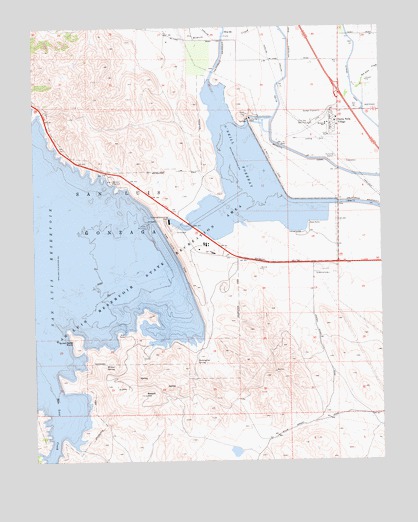
San Luis Dam, CA USGS Topographic Map
Click on map above to begin viewing in our Map Viewer.

This topographic map contains these locations and features:
Feature Name Type Latitude Longitude GNIS ID View Map
Basalt CampgroundLocaleN37.0313°W121.0644°1816734View Map
Basalt Day Use AreaParkN37.0333°W121.0669°1816735View Map
Basalt HillSummitN37.0188°W121.0863°254588View Map
Department of Forestry and Fire Protection Los Bannos StationBuildingN37.0552°W121.0540°2624092View Map
Domengine SpringSpringN37.0290°W121.0676°222478View Map
Fore Bay Golf ClubLocaleN37.0969°W121.0271°1654256View Map
Indian PointCapeN37.0752°W121.0577°1816743View Map
Lone Oak BayBayN37.0119°W121.1160°1816744View Map
Lower Cottonwood Creek Wildlife AreaParkN37.0922°W121.0858°1816754View Map
Meadows Area CampgroundLocaleN37.1086°W121.0649°1816756View Map
Medeiros Area CampgroundLocaleN37.0652°W121.0299°1816755View Map
Merced County Fire Department Station 72 Santa NellaBuildingN37.0936°W121.0196°2624301View Map
Merced County Fire Department Station 73 Los BanosBuildingN37.0552°W121.0540°2624302View Map
North BeachBeachN37.0863°W121.0596°1816760View Map
O'Neill DamDamN37.0844°W121.0408°229834View Map
O'Neill ForebayReservoirN37.0807°W121.0494°254988View Map
O'Neill Forebay Wildlife AreaParkN37.0819°W121.0291°1816762View Map
Oneill DamDamN37.0899°W121.0394°1664640View Map
Oneill Forebay Dike DamDamN37.1133°W121.0544°1664642View Map
Quien Sabe PointCapeN37.0347°W121.1121°231137View Map
Romero CreekStreamN37.1247°W121.0460°231842View Map
Romero OverlookLocaleN37.0805°W121.0980°231843View Map
Romero SchoolSchoolN37.0963°W121.0208°231844View Map
Romero Visitors CenterBuildingN37.0808°W121.0977°1816766View Map
San Joaquin Valley National CemeteryCemeteryN37.1141°W121.0803°2059220View Map
San Luis Creek Area CampgroundLocaleN37.0941°W121.0630°1816767View Map
San Luis DamDamN37.0592°W121.0748°232442View Map
San Luis Dike DamDamN37.1133°W121.0544°1664660View Map
San Luis Pump-Generator PlantBuildingN37.0688°W121.0771°1816770View Map
San Luis Ranch (historical)LocaleN37.0597°W121.0796°1812959View Map
San Luis ReservoirReservoirN37.0573°W121.1211°232446View Map
San Luis Reservoir State Recreation AreaParkN37.0522°W121.1141°248900View Map
Santa Nella Airport (historical)AirportN37.0928°W121.0236°2101580View Map
Santa Nella Census Designated PlaceCensusN37.1014°W121.0154°2583129View Map
Santa Nella VillagePopulated PlaceN37.0977°W121.0169°1659597View Map
South BeachBeachN37.0799°W121.0580°1816771View Map
West Side Community Ambulance Santa NellaBuildingN37.0901°W121.0192°2662251View Map
Willow SpringSpringN37.0276°W121.1004°237936View Map

Note: Coordinates in the location and feature list above are referenced to NAD83 datum.


Copyright (C) 2008-2024 Ryan Niemi / Sunset Dynamics ... All Rights Reserved