TopoQuest Logo
Do you find TopoQuest useful?
Help keep TopoQuest running and adding new maps/features by donating!
Bitcoin:  19c7KJd3qBynnjoSw5npx9KScwjBe4ifkT
Litecoin:  LXs6TkuXGGXo1vDsWCkWVdjQX94eUKd6ui
Home View Maps Find Maps Find Places Resources & Links


Newman, California Topographic Map

USGS Map Title: Newman, CA
USGS Map MRC: 37121C1
DRG (GeoTIFF) Download: o37121c1.tif


Neighboring USGS Topographic Map Quads:


  Patterson, CA  
37121D2
 

  Crows Landing, CA  
37121D1
 

  Hatch, CA  
37120D8
 

  Orestimba Peak, CA  
37121C2
 

  Newman, CA  
37121C1
 

  Gustine, CA  
37120C8
 

  Crevison Peak, CA  
37121B2
 

  Howard Ranch, CA  
37121B1
 

  Ingomar, CA  
37120B8


Map MRC Location:

N38°
W122°
N38°
W121°
H8 H7 H6 H5 H4 H3 H2 H1
G8 G7 G6 G5 G4 G3 G2 G1
F8 F7 F6 F5 F4 F3 F2 F1
E8 E7 E6 E5 E4 E3 E2 E1
D8 D7 D6 D5 D4 D3 D2 D1
C8 C7 C6 C5 C4 C3 C2 C1
B8 B7 B6 B5 B4 B3 B2 B1
A8 A7 A6 A5 A4 A3 A2 A1
N37°
W122°
N37°
W121°

Newman, CA USGS 1:24K Topographic Map Preview:
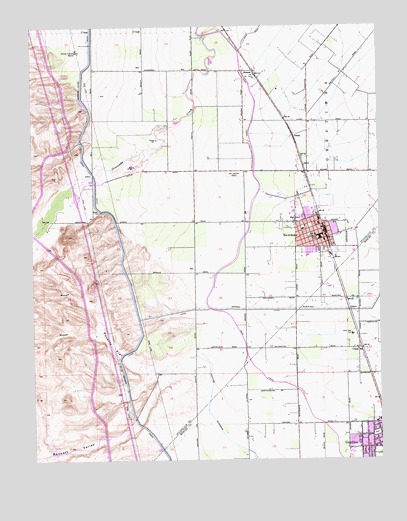
Newman, CA USGS Topographic Map
Click on map above to begin viewing in our Map Viewer.

This topographic map contains these locations and features:
Feature Name Type Latitude Longitude GNIS ID View Map
Bennett ValleyValleyN37.2727°W121.0774°219050View Map
Canal SchoolSchoolN37.2816°W121.0091°220533View Map
City of NewmanCivilN37.3157°W121.0211°2411247View Map
Crow CreekStreamN37.3733°W121.0649°221862View Map
First Baptist ChurchChurchN37.2513°W121.0041°1812936View Map
Gustine Branch Merced County LibraryBuildingN37.2577°W121.0021°1812938View Map
Gustine Community Presbyterian ChurchChurchN37.2555°W121.0027°1812939View Map
Gustine Fire DepartmentBuildingN37.2566°W121.0018°2623675View Map
Gustine High SchoolSchoolN37.2611°W121.0008°1812940View Map
Gustine Police DepartmentBuildingN37.2565°W121.0024°2755860View Map
Harry P Schmidt ParkParkN37.2511°W121.0105°1812941View Map
Henry Miller ParkParkN37.2574°W121.0027°1812942View Map
Highway 33 Egg RanchLocaleN37.2794°W121.0075°2677540View Map
Hunt Elementary SchoolSchoolN37.3193°W121.0291°1817263View Map
Lions ParkParkN37.3194°W121.0330°1817219View Map
Marks Gravel PitMineN37.3358°W121.0900°2680207View Map
NewmanPopulated PlaceN37.3138°W121.0208°277563View Map
Newman Branch Stanislaus County Free LibraryBuildingN37.3163°W121.0280°1817221View Map
Newman Memorial CenterBuildingN37.3185°W121.0330°1817222View Map
Newman PitMineN37.3361°W121.0900°2681435View Map
Newman Police DepartmentBuildingN37.3170°W121.0230°2755745View Map
Newman Post OfficePost OfficeN37.3155°W121.0230°1817223View Map
Newman Waste-WayCanalN37.2930°W121.0041°233356View Map
Newman Youth CenterBuildingN37.3205°W121.0308°1817224View Map
Orestimba High SchoolSchoolN37.3217°W121.0315°1817237View Map
Orestimba School (historical)SchoolN37.3205°W121.1219°1662149View Map
Our Lady of Miracles Catholic SchoolSchoolN37.2554°W121.0075°1812952View Map
Our Lady of Miracles ChurchChurchN37.2558°W121.0080°1812953View Map
Pioneer ParkParkN37.3144°W121.0263°1817246View Map
Poverty FlatFlatN37.2833°W121.0977°231003View Map
San Joachim CemeteryCemeteryN37.3322°W121.0508°232404View Map
Sherwood ParkParkN37.2549°W121.0113°1812961View Map
Stimba Pumping StationLocaleN37.3677°W121.1091°1654469View Map
StomarPopulated PlaceN37.3619°W121.0458°252809View Map
Sullivan ExtensionCanalN37.2572°W121.0574°235695View Map
TimbaPopulated PlaceN37.3427°W121.0310°1660002View Map
Von Renner Elementary SchoolSchoolN37.3089°W121.0270°1817260View Map
West Side Community AmbulanceBuildingN37.2860°W121.0110°2662279View Map
West Side HospitalHospitalN37.2858°W121.0108°1660150View Map
West Stanislaus County Fire Protection District Newman Station 5BuildingN37.3180°W121.0218°2624555View Map
Westside Christian CenterChurchN37.2536°W121.0021°1812965View Map

Note: Coordinates in the location and feature list above are referenced to NAD83 datum.


Copyright (C) 2008-2025 Ryan Niemi / Sunset Dynamics ... All Rights Reserved