TopoQuest Logo
Do you find TopoQuest useful?
Help keep TopoQuest running and adding new maps/features by donating!
Bitcoin:  19c7KJd3qBynnjoSw5npx9KScwjBe4ifkT
Litecoin:  LXs6TkuXGGXo1vDsWCkWVdjQX94eUKd6ui
Home View Maps Find Maps Find Places Resources & Links


Cricket Flat, Oregon Topographic Map

USGS Map Title: Cricket Flat, OR
USGS Map MRC: 45117E7
DRG (GeoTIFF) Download: o45117e7.tif


Neighboring USGS Topographic Map Quads:


  Partridge Creek, OR  
45117F8
 

  Rondowa, OR  
45117F7
 

  Howard Butte, OR  
45117F6
 

  Elgin, OR  
45117E8
 

  Cricket Flat, OR  
45117E7
 

  Minam, OR  
45117E6
 

  Imbler, OR  
45117D8
 

  Gasset Bluff, OR  
45117D7
 

  Mount Moriah, OR  
45117D6


Map MRC Location:

N46°
W118°
N46°
W117°
H8 H7 H6 H5 H4 H3 H2 H1
G8 G7 G6 G5 G4 G3 G2 G1
F8 F7 F6 F5 F4 F3 F2 F1
E8 E7 E6 E5 E4 E3 E2 E1
D8 D7 D6 D5 D4 D3 D2 D1
C8 C7 C6 C5 C4 C3 C2 C1
B8 B7 B6 B5 B4 B3 B2 B1
A8 A7 A6 A5 A4 A3 A2 A1
N45°
W118°
N45°
W117°

Cricket Flat, OR USGS 1:24K Topographic Map Preview:
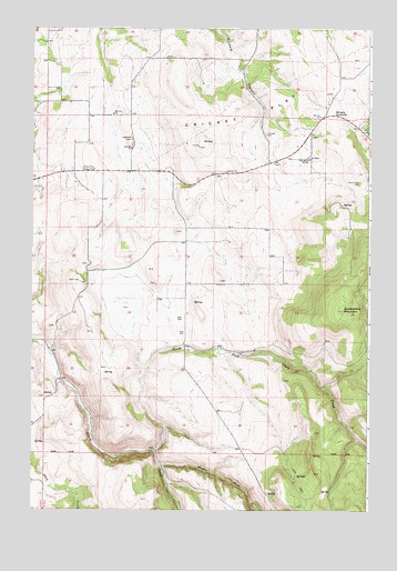
Cricket Flat, OR USGS Topographic Map
Click on map above to begin viewing in our Map Viewer.

This topographic map contains these locations and features:
Feature Name Type Latitude Longitude GNIS ID View Map
Cricket FlatFlatN45.6026°W117.7944°1119546View Map
Cricket Flat Grange HallBuildingN45.5885°W117.8522°1639205View Map
Elk FlatFlatN45.5540°W117.8413°1129475View Map
Elk Flat (historical)Populated PlaceN45.5693°W117.8191°1129476View Map
Elk Flat Post Office (historical)Post OfficeN45.5693°W117.8191°1165204View Map
Highland CemeteryCemeteryN45.5960°W117.8385°1121820View Map
Johnson SpringSpringN45.5354°W117.7816°1129569View Map
Middle Fork Clark CreekStreamN45.5118°W117.8266°1124105View Map
Minam HillSummitN45.5874°W117.7552°1129474View Map
Minam SummitGapN45.6032°W117.7641°1158377View Map
North Fork Clark CreekStreamN45.5160°W117.8294°1146929View Map
Owenby HillSummitN45.5846°W117.7969°1129477View Map
Parsons SpringSpringN45.5796°W117.8721°1129570View Map
Pine Grove CemeteryCemeteryN45.5849°W117.7544°1125401View Map
Pine Grove ChurchChurchN45.5910°W117.7727°1125402View Map
Roulet PondLakeN45.5886°W117.8609°1129473View Map
Stubblefield MountainSummitN45.5521°W117.7599°1127669View Map
Waller Reservoir 2ReservoirN45.5921°W117.7594°1129571View Map
Waller Reservoir 3ReservoirN45.5971°W117.7538°1129491View Map
Waller Reservoir 4ReservoirN45.6096°W117.7646°1130987View Map
Waller Reservoir 6ReservoirN45.6193°W117.7858°1129572View Map
Waller Reservoir Number OneReservoirN45.5982°W117.7533°1130986View Map

Note: Coordinates in the location and feature list above are referenced to NAD83 datum.


Copyright (C) 2008-2024 Ryan Niemi / Sunset Dynamics ... All Rights Reserved