TopoQuest Logo
Do you find TopoQuest useful?
Help keep TopoQuest running and adding new maps/features by donating!
Bitcoin:  19c7KJd3qBynnjoSw5npx9KScwjBe4ifkT
Litecoin:  LXs6TkuXGGXo1vDsWCkWVdjQX94eUKd6ui
Home View Maps Find Maps Find Places Resources & Links


Croghan, New York Topographic Map

USGS Map Title: Croghan, NY
USGS Map MRC: 43075H4
DRG (GeoTIFF) Download: o43075h4.tif


Neighboring USGS Topographic Map Quads:


  North Wilna, NY  
44075A5
 

  Natural Bridge, NY  
44075A4
 

  Remington Corners, NY  
44075A3
 

  Carthage, NY  
43075H5
 

  Croghan, NY  
43075H4
 

  Belfort, NY  
43075H3
 

  West Lowville, NY  
43075G5
 

  Lowville, NY  
43075G4
 

  Crystal Dale, NY  
43075G3


Map MRC Location:

N44°
W76°
N44°
W75°
H8 H7 H6 H5 H4 H3 H2 H1
G8 G7 G6 G5 G4 G3 G2 G1
F8 F7 F6 F5 F4 F3 F2 F1
E8 E7 E6 E5 E4 E3 E2 E1
D8 D7 D6 D5 D4 D3 D2 D1
C8 C7 C6 C5 C4 C3 C2 C1
B8 B7 B6 B5 B4 B3 B2 B1
A8 A7 A6 A5 A4 A3 A2 A1
N43°
W76°
N43°
W75°

Croghan, NY USGS 1:24K Topographic Map Preview:
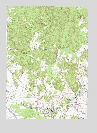
Croghan, NY USGS Topographic Map
Click on map above to begin viewing in our Map Viewer.

This topographic map contains these locations and features:
Feature Name Type Latitude Longitude GNIS ID View Map
Basselin CemeteryCemeteryN43.8945°W75.3920°943146View Map
Beaver FallsPopulated PlaceN43.8870°W75.4274°943383View Map
Beaver Falls Fire DepartmentBuildingN43.8858°W75.4313°2718288View Map
Beaver Falls LibraryBuildingN43.8857°W75.4282°2617217View Map
Beaver Falls New CemeteryCemeteryN43.8875°W75.4405°964294View Map
Beaver Falls Post OfficePost OfficeN43.8861°W75.4303°2617810View Map
Beaver River BridgeBridgeN43.8983°W75.4937°2614872View Map
Beaver River SchoolSchoolN43.8803°W75.4369°943445View Map
Black CreekStreamN43.8942°W75.4057°944122View Map
Charlies HillSummitN43.9542°W75.4141°946411View Map
CroghanPopulated PlaceN43.8959°W75.3924°947761View Map
Croghan Free LibraryBuildingN43.8943°W75.3919°2617254View Map
Croghan Post OfficePost OfficeN43.8931°W75.3931°2617880View Map
Croghan Village Sewage Treatment PlantLocaleN43.8953°W75.3967°2617717View Map
Croghan Volunteer Fire DepartmentBuildingN43.8944°W75.3894°2734777View Map
Forest CityPopulated PlaceN43.9520°W75.4421°972489View Map
Hall Dale AcresLocaleN43.8956°W75.4961°2703261View Map
Monnatt School (historical)SchoolN43.9336°W75.3817°2519079View Map
Murmur CreekStreamN43.9081°W75.3835°958180View Map
NaumburgPopulated PlaceN43.9012°W75.4941°958301View Map
New Life FellowshipChurchN43.8844°W75.4264°2616126View Map
Pine Grove Mennonite ChurchChurchN43.8992°W75.4940°2616239View Map
Pine IslandIslandN43.9545°W75.4074°960488View Map
Putman SwampSwampN43.9684°W75.3852°962001View Map
Reynolds CreekStreamN43.9976°W75.3919°962429View Map
Saint Stephens CemeteryCemeteryN43.9012°W75.3852°964219View Map
Salem Christian Fellowship ChurchChurchN43.8863°W75.4260°2617053View Map
Swiss CreekStreamN43.9428°W75.4580°966942View Map
Swiss Road School (historical)SchoolN43.9025°W75.4108°2519078View Map
Texas Road School (historical)SchoolN43.9831°W75.4700°2519076View Map
Village of CroghanCivilN43.8946°W75.3912°2391629View Map
Widmeyer CreekStreamN43.8859°W75.4474°971224View Map
Wisner School (historical)SchoolN43.9156°W75.4772°2519077View Map
Zion ChurchChurchN43.8998°W75.4916°971883View Map

Note: Coordinates in the location and feature list above are referenced to NAD83 datum.


Copyright (C) 2008-2024 Ryan Niemi / Sunset Dynamics ... All Rights Reserved