TopoQuest Logo
Do you find TopoQuest useful?
Help keep TopoQuest running and adding new maps/features by donating!
Bitcoin:  19c7KJd3qBynnjoSw5npx9KScwjBe4ifkT
Litecoin:  LXs6TkuXGGXo1vDsWCkWVdjQX94eUKd6ui
Home View Maps Find Maps Find Places Resources & Links


West Lowville, New York Topographic Map

USGS Map Title: West Lowville, NY
USGS Map MRC: 43075G5
DRG (GeoTIFF) Download: o43075g5.tif


Neighboring USGS Topographic Map Quads:


  Copenhagen, NY  
43075H6
 

  Carthage, NY  
43075H5
 

  Croghan, NY  
43075H4
 

  New Boston, NY  
43075G6
 

  West Lowville, NY  
43075G5
 

  Lowville, NY  
43075G4
 

  Sears Pond, NY  
43075F6
 

  Page, NY  
43075F5
 

  Glenfield, NY  
43075F4


Map MRC Location:

N44°
W76°
N44°
W75°
H8 H7 H6 H5 H4 H3 H2 H1
G8 G7 G6 G5 G4 G3 G2 G1
F8 F7 F6 F5 F4 F3 F2 F1
E8 E7 E6 E5 E4 E3 E2 E1
D8 D7 D6 D5 D4 D3 D2 D1
C8 C7 C6 C5 C4 C3 C2 C1
B8 B7 B6 B5 B4 B3 B2 B1
A8 A7 A6 A5 A4 A3 A2 A1
N43°
W76°
N43°
W75°

West Lowville, NY USGS 1:24K Topographic Map Preview:
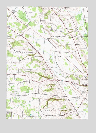
West Lowville, NY USGS Topographic Map
Click on map above to begin viewing in our Map Viewer.

This topographic map contains these locations and features:
Feature Name Type Latitude Longitude GNIS ID View Map
Briggs CornerPopulated PlaceN43.8745°W75.5357°972259View Map
Cedars Golf CourseLocaleN43.8682°W75.5184°2615365View Map
Fairview CemeteryCemeteryN43.8515°W75.5187°949842View Map
Gallup CemeteryCemeteryN43.8518°W75.6243°970155View Map
HarrisburgPopulated PlaceN43.8423°W75.6027°972601View Map
Northern Quest FarmLocaleN43.8161°W75.5978°2703259View Map
Riverjack RanchLocaleN43.8719°W75.5031°2703260View Map
School Number 11 (historical)SchoolN43.7542°W75.5596°975008View Map
School Number 11 (historical)SchoolN43.8695°W75.6177°975009View Map
School Number 12 (historical)SchoolN43.8712°W75.5552°975047View Map
School Number 13 (historical)SchoolN43.7576°W75.6232°975073View Map
School Number 14 (historical)SchoolN43.7781°W75.5785°975096View Map
School Number 16 (historical)SchoolN43.7776°W75.6196°975132View Map
School Number 2 (historical)SchoolN43.8431°W75.6047°2353112View Map
School Number 3 (historical)SchoolN43.8331°W75.5188°975292View Map
School Number 4 (historical)SchoolN43.7995°W75.6241°975376View Map
School Number 4 (historical)SchoolN43.8237°W75.5424°975377View Map
School Number 5 (historical)SchoolN43.7559°W75.5152°975450View Map
School Number 5 (historical)SchoolN43.8384°W75.5619°975452View Map
School Number 6 (historical)SchoolN43.7922°W75.5464°2353113View Map
School Number 7 (historical)SchoolN43.8134°W75.5652°975570View Map
School Number 9 (historical)SchoolN43.8478°W75.5152°975663View Map
Town of LowvilleCivilN43.8162°W75.5236°979171View Map
Tug Hill Farm Airport (historical)AirportN43.7778°W75.6069°978125View Map
West LowvillePopulated PlaceN43.7934°W75.5477°970786View Map
West Lowville Rural CemeteryCemeteryN43.8048°W75.5571°963092View Map
West MartinsburgPopulated PlaceN43.7595°W75.5174°970789View Map
WindeckerPopulated PlaceN43.7992°W75.6124°973276View Map
Windy AcresLocaleN43.8475°W75.5858°2708359View Map
WLLG-FM (Lowville)TowerN43.7534°W75.5635°977753View Map

Note: Coordinates in the location and feature list above are referenced to NAD83 datum.


Copyright (C) 2008-2025 Ryan Niemi / Sunset Dynamics ... All Rights Reserved