TopoQuest Logo
Do you find TopoQuest useful?
Help keep TopoQuest running and adding new maps/features by donating!
Bitcoin:  19c7KJd3qBynnjoSw5npx9KScwjBe4ifkT
Litecoin:  LXs6TkuXGGXo1vDsWCkWVdjQX94eUKd6ui
Home View Maps Find Maps Find Places Resources & Links


Cross Plains, Indiana Topographic Map

USGS Map Title: Cross Plains, IN
USGS Map MRC: 38085H2
DRG (GeoTIFF) Download: o38085h2.tif


Neighboring USGS Topographic Map Quads:


  Versailles, IN  
39085A3
 

  Milan, IN  
39085A2
 

  Dillsboro, IN  
39085A1
 

  Rexville, IN  
38085H3
 

  Cross Plains, IN  
38085H2
 

  Bear Branch, IN  
38085H1
 

  Canaan, IN  
38085G3
 

  Bennington, IN  
38085G2
 

  Vevay North, IN  
38085G1


Map MRC Location:

N39°
W86°
N39°
W85°
H8 H7 H6 H5 H4 H3 H2 H1
G8 G7 G6 G5 G4 G3 G2 G1
F8 F7 F6 F5 F4 F3 F2 F1
E8 E7 E6 E5 E4 E3 E2 E1
D8 D7 D6 D5 D4 D3 D2 D1
C8 C7 C6 C5 C4 C3 C2 C1
B8 B7 B6 B5 B4 B3 B2 B1
A8 A7 A6 A5 A4 A3 A2 A1
N38°
W86°
N38°
W85°

Cross Plains, IN USGS 1:24K Topographic Map Preview:
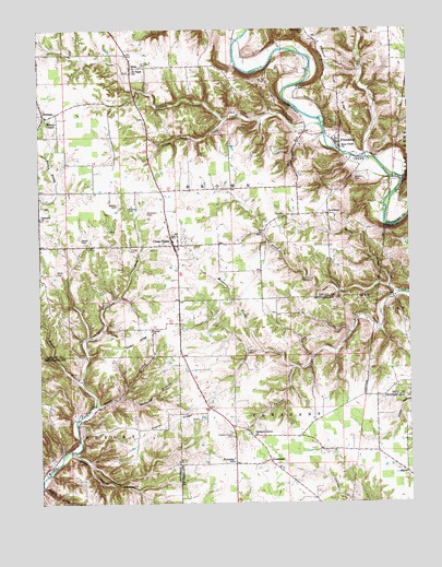
Cross Plains, IN USGS Topographic Map
Click on map above to begin viewing in our Map Viewer.

This topographic map contains these locations and features:
Feature Name Type Latitude Longitude GNIS ID View Map
AaronPopulated PlaceN38.8831°W85.1258°429980View Map
Akers CemeteryCemeteryN38.9756°W85.1491°430035View Map
Arlington Avenue Baptist ChurchChurchN38.9506°W85.1669°430242View Map
AvonburgPopulated PlaceN38.8864°W85.1722°430360View Map
Basset CemeteryCemeteryN38.9528°W85.2194°430567View Map
Bear Creek CemeteryCemeteryN38.9289°W85.1372°430635View Map
Bear Creek ChurchChurchN38.9684°W85.1475°430639View Map
Beebe CemeteryCemeteryN38.9445°W85.2358°430709View Map
Black BranchStreamN38.9076°W85.2358°431118View Map
Black CreekStreamN38.9301°W85.1286°431125View Map
Caesar CreekStreamN38.9662°W85.1386°431938View Map
Concord ChurchChurchN38.9503°W85.2497°432860View Map
Connell CemeteryCemeteryN38.9850°W85.1616°432884View Map
Cross PlainsPopulated PlaceN38.9439°W85.2047°449643View Map
Devils BackboneRidgeN38.8814°W85.2291°433500View Map
DewberryPopulated PlaceN38.9512°W85.1516°433519View Map
FriendshipPopulated PlaceN38.9703°W85.1477°434856View Map
Friendship CemeteryCemeteryN38.9984°W85.1597°434859View Map
Friendship Volunteer Fire DepartmentBuildingN38.9730°W85.1516°2625568View Map
Horton HollowValleyN38.8795°W85.2495°436499View Map
Little CreekStreamN38.9312°W85.1313°438023View Map
Little Raccoon CreekStreamN38.9762°W85.1861°438124View Map
McCurry BranchStreamN38.9028°W85.2238°438846View Map
Miller BranchStreamN38.8887°W85.2405°439179View Map
Mosquito CreekStreamN38.9148°W85.1741°439493View Map
Myers CemeteryCemeteryN38.9359°W85.2441°439915View Map
Nickolson CemeteryCemeteryN38.9517°W85.2130°440168View Map
OleanPopulated PlaceN38.9903°W85.2186°440628View Map
Pleasant Grove CemeteryCemeteryN38.8926°W85.1850°441246View Map
Pleasant Grove ChurchChurchN38.8923°W85.1775°441256View Map
Poplar RidgeRidgeN38.8973°W85.2058°441448View Map
Possum Trot RidgeRidgeN38.9856°W85.1511°441487View Map
Raccoon CreekStreamN38.9748°W85.1544°441718View Map
Rost RunStreamN38.9739°W85.1594°442330View Map
Saint Pauls ChurchChurchN38.9889°W85.2180°442772View Map
Saint Peters CemeteryCemeteryN38.9903°W85.2150°442800View Map
Salem BranchStreamN38.9009°W85.2313°442877View Map
Salem ChurchChurchN38.9206°W85.2125°442905View Map
Salem RidgeRidgeN38.9170°W85.2175°442929View Map
Township of BrownCivilN38.9642°W85.2123°453141View Map
Uhlman CreekStreamN38.9109°W85.1627°445032View Map
Wesley ChapelChurchN38.9770°W85.2472°445695View Map
Wilson CemeteryCemeteryN38.9606°W85.1427°446126View Map
Winkler CemeteryCemeteryN38.9537°W85.2233°446186View Map
Young CemeteryCemeteryN38.9420°W85.2191°446411View Map

Note: Coordinates in the location and feature list above are referenced to NAD83 datum.


Copyright (C) 2008-2025 Ryan Niemi / Sunset Dynamics ... All Rights Reserved