TopoQuest Logo
Do you find TopoQuest useful?
Help keep TopoQuest running and adding new maps/features by donating!
Bitcoin:  19c7KJd3qBynnjoSw5npx9KScwjBe4ifkT
Litecoin:  LXs6TkuXGGXo1vDsWCkWVdjQX94eUKd6ui
Home View Maps Find Maps Find Places Resources & Links


Cross Roads, California Topographic Map

USGS Map Title: Cross Roads, CA
USGS Map MRC: 34114B2
DRG (GeoTIFF) Download: o34114b2.tif


Neighboring USGS Topographic Map Quads:


  Whipple Wash, CA  
34114C3
 

  Gene Wash, CA  
34114C2
 

  Monkeys Head, AZ  
34114C1
 

  Parker, AZ  
34114B3
 

  Cross Roads, CA  
34114B2
 

  Osborne Well, AZ  
34114B1
 

  Parker SE, AZ  
34114A3
 

  Black Peak, AZ  
34114A2
 

  Bobs Well, AZ  
34114A1


Map MRC Location:

N35°
W115°
N35°
W114°
H8 H7 H6 H5 H4 H3 H2 H1
G8 G7 G6 G5 G4 G3 G2 G1
F8 F7 F6 F5 F4 F3 F2 F1
E8 E7 E6 E5 E4 E3 E2 E1
D8 D7 D6 D5 D4 D3 D2 D1
C8 C7 C6 C5 C4 C3 C2 C1
B8 B7 B6 B5 B4 B3 B2 B1
A8 A7 A6 A5 A4 A3 A2 A1
N34°
W115°
N34°
W114°

Cross Roads, CA USGS 1:24K Topographic Map Preview:
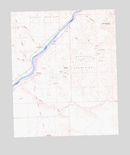
Cross Roads, CA USGS Topographic Map
Click on map above to begin viewing in our Map Viewer.

This topographic map contains these locations and features:
Feature Name Type Latitude Longitude GNIS ID View Map
Ah Villa ParkParkN34.2267°W114.1916°22731View Map
Bennett WashStreamN34.2014°W114.2272°239224View Map
Billy Mack MineMineN34.1892°W114.1905°1423View Map
Billy Mack MountainSummitN34.1922°W114.1841°1424View Map
Bowmans WashStreamN34.2142°W114.2108°239618View Map
Bransons Mobile Home ParkPopulated PlaceN34.2200°W114.1990°2670140View Map
Buckskin Fire Department Station 11BuildingN34.2113°W114.2093°2672403View Map
Carnation MineMineN34.1989°W114.1469°2468View Map
Christ's Church on the RiverChurchN34.1974°W114.2222°2670751View Map
Cienega SpringsPopulated PlaceN34.1886°W114.2247°24372View Map
Cienega Springs Census Designated PlaceCensusN34.1930°W114.2159°2582756View Map
Copper Basin WashStreamN34.2472°W114.1752°240903View Map
Cross RoadsPopulated PlaceN34.2145°W114.2158°241123View Map
Eagle WashStreamN34.2342°W114.1844°4253View Map
Eagles Nest MineMineN34.2097°W114.1447°4254View Map
Emerald Canyon Golf CourseLocaleN34.2243°W114.1887°2670247View Map
Empire FlatFlatN34.2228°W114.1944°4446View Map
Giers MountainSummitN34.2350°W114.1361°5010View Map
Gray Eagle MineMineN34.2139°W114.1508°5313View Map
Lion HillSummitN34.1836°W114.1863°7051View Map
Osborne WashStreamN34.1758°W114.2427°9021View Map
Parker StripPopulated PlaceN34.2194°W114.1982°2413657View Map
Red MountainSummitN34.2386°W114.1522°10096View Map
Rio Vista MineMineN34.1778°W114.2008°10310View Map
San Bernardino County Fire Department Station 21 Parker StripBuildingN34.2215°W114.2073°2665013View Map
Sandbar Resort Red Rock CampgroundsLocaleN34.2295°W114.1893°2669724View Map
Sue MineMineN34.1931°W114.2119°11908View Map

Note: Coordinates in the location and feature list above are referenced to NAD83 datum.


Copyright (C) 2008-2025 Ryan Niemi / Sunset Dynamics ... All Rights Reserved