TopoQuest Logo
Do you find TopoQuest useful?
Help keep TopoQuest running and adding new maps/features by donating!
Bitcoin:  19c7KJd3qBynnjoSw5npx9KScwjBe4ifkT
Litecoin:  LXs6TkuXGGXo1vDsWCkWVdjQX94eUKd6ui
Home View Maps Find Maps Find Places Resources & Links


Crystal Springs, Arkansas Topographic Map

USGS Map Title: Crystal Springs, AR
USGS Map MRC: 34093E3
DRG (GeoTIFF) Download: o34093e3.tif


Neighboring USGS Topographic Map Quads:


  Fannie, AR  
34093F4
 

  Avant, AR  
34093F3
 

  Hamilton, AR  
34093F2
 

  McGraw Mountain, AR  
34093E4
 

  Crystal Springs, AR  
34093E3
 

  Mountain Pine, AR  
34093E2
 

  Bonnerdale, AR  
34093D4
 

  Pearcy, AR  
34093D3
 

  Hempwallace, AR  
34093D2


Map MRC Location:

N35°
W94°
N35°
W93°
H8 H7 H6 H5 H4 H3 H2 H1
G8 G7 G6 G5 G4 G3 G2 G1
F8 F7 F6 F5 F4 F3 F2 F1
E8 E7 E6 E5 E4 E3 E2 E1
D8 D7 D6 D5 D4 D3 D2 D1
C8 C7 C6 C5 C4 C3 C2 C1
B8 B7 B6 B5 B4 B3 B2 B1
A8 A7 A6 A5 A4 A3 A2 A1
N34°
W94°
N34°
W93°

Crystal Springs, AR USGS 1:24K Topographic Map Preview:
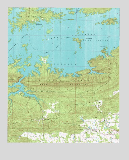
Crystal Springs, AR USGS Topographic Map
Click on map above to begin viewing in our Map Viewer.

This topographic map contains these locations and features:
Feature Name Type Latitude Longitude GNIS ID View Map
Arkansas Noname 136 DamDamN34.5218°W93.2919°80372View Map
Arkansas Noname 136 ReservoirReservoirN34.5218°W93.2920°80373View Map
BearPopulated PlaceN34.5345°W93.2738°76263View Map
Bear MountainRidgeN34.5537°W93.3166°70568View Map
Brady Mountain Public Use AreaParkN34.5881°W93.2649°76409View Map
Brooks CemeteryCemeteryN34.6162°W93.3391°70832View Map
Bucksville (historical)Populated PlaceN34.6123°W93.3405°64292View Map
Buckville CemeteriesCemeteryN34.6143°W93.3438°70906View Map
Buckville Public Use AreaParkN34.6106°W93.3452°76456View Map
Cedar Fourche CreekStreamN34.6195°W93.2980°71084View Map
Cedar Glades (historical)Populated PlaceN34.6126°W93.2974°85446View Map
Church of GodChurchN34.5287°W93.2705°64298View Map
Crystal SpringsPopulated PlaceN34.5220°W93.3360°76725View Map
Crystal Springs LandingPopulated PlaceN34.5473°W93.3613°71307View Map
Crystal Springs Public Use AreaParkN34.5470°W93.3613°64300View Map
Crystal Springs Recreation SiteLocaleN34.5465°W93.3594°74441View Map
Lake OuachitaReservoirN34.6065°W93.3478°75813View Map
Little Bear CreekStreamN34.5465°W93.3549°72365View Map
Lowe CemeteryCemeteryN34.5095°W93.2855°72511View Map
Piney Fire Department Station 3BuildingN34.5175°W93.3360°2116977View Map
Rector LakeReservoirN34.5212°W93.2907°80375View Map
Rector Lake DamDamN34.5206°W93.2902°80374View Map
Rouse CreekStreamN34.5345°W93.2863°73423View Map
Social Hill ChurchChurchN34.5134°W93.2841°73637View Map
Township of Bear (historical)CivilN34.5390°W93.2794°64286View Map
Township of Cedar Glades (historical)CivilN34.6043°W93.2835°64295View Map
Township of Crystal (historical)CivilN34.5501°W93.3627°64301View Map
Township of Valley (historical)CivilN34.5412°W93.3044°66601View Map
Valley SchoolSchoolN34.5076°W93.2752°73956View Map
Walnut CreekStreamN34.5618°W93.3569°73996View Map

Note: Coordinates in the location and feature list above are referenced to NAD83 datum.


Copyright (C) 2008-2025 Ryan Niemi / Sunset Dynamics ... All Rights Reserved