TopoQuest Logo
Do you find TopoQuest useful?
Help keep TopoQuest running and adding new maps/features by donating!
Bitcoin:  19c7KJd3qBynnjoSw5npx9KScwjBe4ifkT
Litecoin:  LXs6TkuXGGXo1vDsWCkWVdjQX94eUKd6ui
Home View Maps Find Maps Find Places Resources & Links


Mountain Pine, Arkansas Topographic Map

USGS Map Title: Mountain Pine, AR
USGS Map MRC: 34093E2
DRG (GeoTIFF) Download: o34093e2.tif


Neighboring USGS Topographic Map Quads:


  Avant, AR  
34093F3
 

  Hamilton, AR  
34093F2
 

  Jessieville, AR  
34093F1
 

  Crystal Springs, AR  
34093E3
 

  Mountain Pine, AR  
34093E2
 

  Hot Springs North, AR  
34093E1
 

  Pearcy, AR  
34093D3
 

  Hempwallace, AR  
34093D2
 

  Hot Springs South, AR  
34093D1


Map MRC Location:

N35°
W94°
N35°
W93°
H8 H7 H6 H5 H4 H3 H2 H1
G8 G7 G6 G5 G4 G3 G2 G1
F8 F7 F6 F5 F4 F3 F2 F1
E8 E7 E6 E5 E4 E3 E2 E1
D8 D7 D6 D5 D4 D3 D2 D1
C8 C7 C6 C5 C4 C3 C2 C1
B8 B7 B6 B5 B4 B3 B2 B1
A8 A7 A6 A5 A4 A3 A2 A1
N34°
W94°
N34°
W93°

Mountain Pine, AR USGS 1:24K Topographic Map Preview:
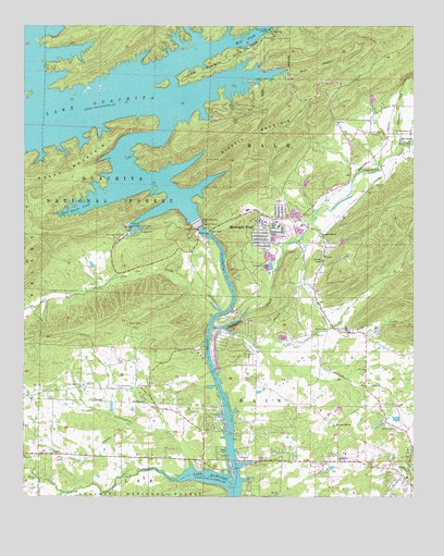
Mountain Pine, AR USGS Topographic Map
Click on map above to begin viewing in our Map Viewer.

This topographic map contains these locations and features:
Feature Name Type Latitude Longitude GNIS ID View Map
Avery CemeteryCemeteryN34.5311°W93.1774°70482View Map
Bear CreekStreamN34.6131°W93.1669°70547View Map
Bear CreekStreamN34.5001°W93.2377°70554View Map
Blakely MountainRidgeN34.5973°W93.1769°70711View Map
Blakely Mountain DamDamN34.5734°W93.1885°79570View Map
Brady MountainSummitN34.5851°W93.2457°70794View Map
Cearley CreekStreamN34.5048°W93.2021°71049View Map
Cedar Glades Baptist ChurchChurchN34.5968°W93.1263°76558View Map
City of Mountain PineCivilN34.5702°W93.1722°2404332View Map
Clear CreekStreamN34.5448°W93.1863°71163View Map
Coker CemeteryCemeteryN34.5102°W93.1323°71184View Map
Crudington CreekStreamN34.5081°W93.1963°71298View Map
Crystal Hill ChurchChurchN34.5190°W93.1496°71300View Map
Cunningham CemeteryCemeteryN34.5293°W93.2202°71316View Map
Fleming CemeteryCemeteryN34.5091°W93.1525°71634View Map
Garland CountyCivilN34.5767°W93.1504°66855View Map
Gibbons CemeteryCemeteryN34.5012°W93.1794°71748View Map
Glazypeau CreekStreamN34.5445°W93.1896°77024View Map
Godwin CemeteryCemeteryN34.5445°W93.1571°71779View Map
Gospel MissionChurchN34.5695°W93.1546°71792View Map
Greenwood ChurchChurchN34.5098°W93.1494°71839View Map
Gum Spring ChurchChurchN34.5940°W93.1266°71858View Map
Harveys Chapel Baptist ChurchChurchN34.5629°W93.1544°77140View Map
HawesPopulated PlaceN34.5501°W93.1549°64314View Map
Lake Ouachita State ParkParkN34.6159°W93.1846°72280View Map
Little Glazypeau CreekStreamN34.5931°W93.1288°72395View Map
Mill CreekStreamN34.6123°W93.2099°72660View Map
Mountain PinePopulated PlaceN34.5720°W93.1732°72790View Map
Mountain Pine Elementary SchoolSchoolN34.5770°W93.1764°64335View Map
Mountain Pine High SchoolSchoolN34.5765°W93.1784°64336View Map
Mountain Pine Police DepartmentBuildingN34.5717°W93.1746°2118801View Map
Mountain Pine Post OfficePost OfficeN34.5732°W93.1737°2781935View Map
Mountain Pine Volunteer Fire StationBuildingN34.5746°W93.1705°2116831View Map
New Home ChurchChurchN34.5293°W93.2321°72853View Map
New Salem ChurchChurchN34.5443°W93.1466°72859View Map
Ouachita Job Corps Conservation CenterLocaleN34.5393°W93.1955°74561View Map
Owl CreekStreamN34.5493°W93.1871°72968View Map
PineyPopulated PlaceN34.5031°W93.1260°73101View Map
Piney Census Designated PlaceCensusN34.5023°W93.1419°2403421View Map
Piney Fire Department Station 2BuildingN34.5110°W93.2208°2116976View Map
Piney Fire Department Station 4BuildingN34.5804°W93.1531°2116978View Map
Rabbit CreekStreamN34.5448°W93.1519°73225View Map
RoyalPopulated PlaceN34.5115°W93.2410°73430View Map
Royal ChurchChurchN34.5109°W93.2499°73431View Map
Scott CemeteryCemeteryN34.5965°W93.1355°73498View Map
Spillway LandingLocaleN34.5718°W93.2157°73667View Map
Spillway Public Use AreaParkN34.5695°W93.2144°64354View Map
Spillway Recreation SiteLocaleN34.5698°W93.2146°74560View Map
Steep Shoals CreekStreamN34.5779°W93.2285°73695View Map
Three Sisters LandingLocaleN34.6240°W93.1716°73871View Map
Township of Bain (historical)CivilN34.5293°W93.1502°66589View Map
Township of HaleCivilN34.6216°W93.2353°66591View Map
Township of Ouachita (historical)CivilN34.5529°W93.2127°64341View Map

Note: Coordinates in the location and feature list above are referenced to NAD83 datum.


Copyright (C) 2008-2025 Ryan Niemi / Sunset Dynamics ... All Rights Reserved