TopoQuest Logo
Do you find TopoQuest useful?
Help keep TopoQuest running and adding new maps/features by donating!
Bitcoin:  19c7KJd3qBynnjoSw5npx9KScwjBe4ifkT
Litecoin:  LXs6TkuXGGXo1vDsWCkWVdjQX94eUKd6ui
Home View Maps Find Maps Find Places Resources & Links


McGraw Mountain, Arkansas Topographic Map

USGS Map Title: McGraw Mountain, AR
USGS Map MRC: 34093E4
DRG (GeoTIFF) Download: o34093e4.tif


Neighboring USGS Topographic Map Quads:


  Story, AR  
34093F5
 

  Fannie, AR  
34093F4
 

  Avant, AR  
34093F3
 

  Reed Mountain, AR  
34093E5
 

  McGraw Mountain, AR  
34093E4
 

  Crystal Springs, AR  
34093E3
 

  Caddo Gap, AR  
34093D5
 

  Bonnerdale, AR  
34093D4
 

  Pearcy, AR  
34093D3


Map MRC Location:

N35°
W94°
N35°
W93°
H8 H7 H6 H5 H4 H3 H2 H1
G8 G7 G6 G5 G4 G3 G2 G1
F8 F7 F6 F5 F4 F3 F2 F1
E8 E7 E6 E5 E4 E3 E2 E1
D8 D7 D6 D5 D4 D3 D2 D1
C8 C7 C6 C5 C4 C3 C2 C1
B8 B7 B6 B5 B4 B3 B2 B1
A8 A7 A6 A5 A4 A3 A2 A1
N34°
W94°
N34°
W93°

McGraw Mountain, AR USGS 1:24K Topographic Map Preview:
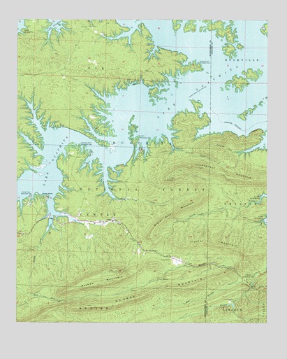
McGraw Mountain, AR USGS Topographic Map
Click on map above to begin viewing in our Map Viewer.

This topographic map contains these locations and features:
Feature Name Type Latitude Longitude GNIS ID View Map
Arnold CreekStreamN34.5762°W93.4244°70466View Map
Bashaw MountainRidgeN34.5159°W93.4588°70524View Map
Big Fir Public Use AreaParkN34.6062°W93.4096°77241View Map
Broken Rock MountainRidgeN34.5451°W93.4213°70830View Map
Camp Clear Fork ReservoirReservoirN34.5076°W93.3941°80377View Map
Camp ClearforkLocaleN34.5090°W93.3916°70968View Map
Camp Clearfork Lake DamDamN34.5084°W93.3919°80376View Map
Caney CreekStreamN34.5498°W93.3807°70991View Map
Charlton Public Use AreaParkN34.5176°W93.3835°76592View Map
Crystal MountainRidgeN34.5326°W93.4021°71301View Map
Denby CreekStreamN34.5448°W93.4824°71365View Map
Denby PointCapeN34.5518°W93.4849°71366View Map
Denby Point Public Use AreaParkN34.5520°W93.4935°76781View Map
Fir (historical)Populated PlaceN34.5876°W93.4391°70098View Map
Gap CreekStreamN34.5520°W93.4830°71719View Map
Gap Creek Recreation SiteLocaleN34.5423°W93.4482°74445View Map
Harbor ChapelChurchN34.5590°W93.4710°63506View Map
Hickory Nut Mountain CampgroundLocaleN34.5612°W93.4238°74448View Map
Hickorynut Lookout TowerTowerN34.5598°W93.4224°82443View Map
Hickorynut MountainRidgeN34.5601°W93.3935°77178View Map
Irons CreekStreamN34.5643°W93.4566°72150View Map
JoplinPopulated PlaceN34.5423°W93.4527°72219View Map
Joplin CemeteryCemeteryN34.5429°W93.4507°63520View Map
Joplin Public Use AreaParkN34.5754°W93.4405°77390View Map
Joplin School (historical)SchoolN34.5423°W93.4521°63521View Map
Joplin Volunteer Fire StationBuildingN34.5669°W93.4404°2116657View Map
Lake Ouachita Nursery PondReservoirN34.5876°W93.4682°80627View Map
Lake Ouachita Nursery Pond DamDamN34.5851°W93.4669°80626View Map
Lake Ouachita Vista Point of InterestLocaleN34.5679°W93.4077°74447View Map
Little Fir CemeteryCemeteryN34.6220°W93.4655°72391View Map
Little Fir School (historical)SchoolN34.6226°W93.4660°63527View Map
McGraw MountainRidgeN34.5112°W93.4360°72596View Map
Murphy CemeteryCemeteryN34.5259°W93.4238°72817View Map
Murphy CreekStreamN34.5151°W93.3827°72818View Map
North Fork Ouachita RiverStreamN34.6048°W93.3952°72887View Map
Pollard CreekStreamN34.5731°W93.3791°73156View Map
Red BranchStreamN34.5170°W93.3869°73248View Map
Tompkins Bend Public Use AreaParkN34.5731°W93.4691°83619View Map
Township of Fir (historical)CivilN34.6181°W93.4627°63488View Map

Note: Coordinates in the location and feature list above are referenced to NAD83 datum.


Copyright (C) 2008-2025 Ryan Niemi / Sunset Dynamics ... All Rights Reserved