TopoQuest Logo
Do you find TopoQuest useful?
Help keep TopoQuest running and adding new maps/features by donating!
Bitcoin:  19c7KJd3qBynnjoSw5npx9KScwjBe4ifkT
Litecoin:  LXs6TkuXGGXo1vDsWCkWVdjQX94eUKd6ui
Home View Maps Find Maps Find Places Resources & Links


Curtisville, Pennsylvania Topographic Map

USGS Map Title: Curtisville, PA
USGS Map MRC: 40079F7
DRG (GeoTIFF) Download: o40079f7.tif


Neighboring USGS Topographic Map Quads:


  Butler, PA  
40079G8
 

  Saxonburg, PA  
40079G7
 

  Worthington, PA  
40079G6
 

  Valencia, PA  
40079F8
 

  Curtisville, PA  
40079F7
 

  Freeport, PA  
40079F6
 

  Glenshaw, PA  
40079E8
 

  New Kensington West, PA  
40079E7
 

  New Kensington East, PA  
40079E6


Map MRC Location:

N41°
W80°
N41°
W79°
H8 H7 H6 H5 H4 H3 H2 H1
G8 G7 G6 G5 G4 G3 G2 G1
F8 F7 F6 F5 F4 F3 F2 F1
E8 E7 E6 E5 E4 E3 E2 E1
D8 D7 D6 D5 D4 D3 D2 D1
C8 C7 C6 C5 C4 C3 C2 C1
B8 B7 B6 B5 B4 B3 B2 B1
A8 A7 A6 A5 A4 A3 A2 A1
N40°
W80°
N40°
W79°

Curtisville, PA USGS 1:24K Topographic Map Preview:
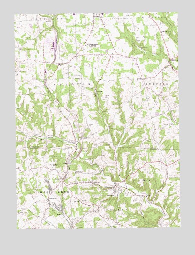
Curtisville, PA USGS Topographic Map
Click on map above to begin viewing in our Map Viewer.

This topographic map contains these locations and features:
Feature Name Type Latitude Longitude GNIS ID View Map
BenjaminPopulated PlaceN40.6337°W79.8398°1203064View Map
BlanchardPopulated PlaceN40.6573°W79.8284°1169807View Map
Buffalo Township Elementary SchoolSchoolN40.7226°W79.7542°1210525View Map
Buffalo Township Emergency Medical Ambulance ServicesBuildingN40.7086°W79.7747°2719536View Map
Bull Creek CemeteryCemeteryN40.6415°W79.8262°1170636View Map
Bull Creek ChurchChurchN40.6403°W79.8262°1170637View Map
Carnegie Institute of TechnologySchoolN40.7323°W79.8178°1171228View Map
Cherry ValleyValleyN40.6744°W79.8291°1171681View Map
ClintonPopulated PlaceN40.7242°W79.7856°1172014View Map
Clinton ChurchChurchN40.7220°W79.8701°1172017View Map
Clinton Elementary SchoolSchoolN40.7201°W79.8401°1210545View Map
Clinton United Pentecostal ChurchChurchN40.7226°W79.8705°2430388View Map
Coal HollowPopulated PlaceN40.7295°W79.7776°1172055View Map
Cooper Airport (historical)AirportN40.7334°W79.7664°1194086View Map
CulmervillePopulated PlaceN40.6542°W79.8389°1172818View Map
Culmerville AirportAirportN40.6635°W79.8467°1194058View Map
CunninghamPopulated PlaceN40.6776°W79.8228°1203378View Map
CurtisvillePopulated PlaceN40.6423°W79.8509°1172859View Map
Curtisville Census Designated PlaceCensusN40.6497°W79.8492°2389386View Map
Curtisville Post OfficePost OfficeN40.6403°W79.8502°2777477View Map
Davis RunStreamN40.7478°W79.8442°1172992View Map
Deer Creek United Presbyterian ChurchChurchN40.6266°W79.8611°2430418View Map
East Union United Presbyterian ChurchChurchN40.6251°W79.8584°2430429View Map
EkastownPopulated PlaceN40.7112°W79.7764°1174066View Map
Fawn Township Police DepartmentBuildingN40.6579°W79.7583°2780123View Map
Fawn Township Volunteer Fire Department 1 Station 150BuildingN40.6506°W79.7917°2644908View Map
Frazer Township Volunteer Fire Department 1 Station 159BuildingN40.6302°W79.8016°2645213View Map
Greisinger DamDamN40.6767°W79.8681°1194970View Map
Greisinger PondReservoirN40.6766°W79.8710°1194969View Map
HousevillePopulated PlaceN40.7262°W79.8428°1203848View Map
IvywoodPopulated PlaceN40.7109°W79.8517°1177895View Map
Knoch Junior Senior High SchoolSchoolN40.7498°W79.8289°1211579View Map
LardintownPopulated PlaceN40.7051°W79.8126°1178889View Map
Lardintown RunStreamN40.6487°W79.7892°1178890View Map
LernervillePopulated PlaceN40.7381°W79.7623°1179211View Map
McDowell RunStreamN40.6378°W79.7728°1180700View Map
MillerstownPopulated PlaceN40.6501°W79.7989°1181259View Map
Millerstown CemeteryCemeteryN40.6490°W79.7985°2775028View Map
Mineral SpringPopulated PlaceN40.7262°W79.8006°1201547View Map
Oak Grove CemeteryCemeteryN40.6852°W79.8193°1182739View Map
Our Lady of Hope CemeteryCemeteryN40.6282°W79.7898°2775049View Map
Pleasant Unity CemeteryCemeteryN40.6518°W79.8168°2775054View Map
Pleasant Unity ChurchChurchN40.6520°W79.8156°1184058View Map
Red HotPopulated PlaceN40.6631°W79.8359°1204470View Map
Rocky RunStreamN40.6745°W79.8281°1185366View Map
Saint Andrew the Apostle Byzantine Catholic ChurchChurchN40.6361°W79.8567°2431199View Map
Saint Paul ChurchChurchN40.7178°W79.7603°1186553View Map
Saint Victors ChurchChurchN40.6342°W79.8737°1186765View Map
Sarver Post OfficePost OfficeN40.7119°W79.7770°2431935View Map
Sarver Volunteer Fire Company Station 36BuildingN40.6926°W79.7580°2645637View Map
SarversvillePopulated PlaceN40.7195°W79.7556°1200115View Map
Saxon Airport (historical)AirportN40.7298°W79.7914°1194082View Map
Saxon Golf CourseLocaleN40.7251°W79.7998°1205256View Map
Saxonburg Post OfficePost OfficeN40.7499°W79.8145°2431936View Map
Saxonburg Volunteer Fire Department Station 15BuildingN40.7477°W79.8138°2645154View Map
Township of ClintonCivilN40.7076°W79.8311°1216049View Map
Township of FawnCivilN40.6500°W79.7674°1215803View Map
Township of West DeerCivilN40.6350°W79.8693°1215837View Map
Transfiguration SchoolSchoolN40.6255°W79.8431°2431603View Map
West Deer Township Volunteer Fire Department 1 Station 288BuildingN40.6537°W79.8405°2645905View Map
West SaxonburgPopulated PlaceN40.7467°W79.8464°1191107View Map
Westminster ChurchChurchN40.7126°W79.8237°1191165View Map
WoodsLocaleN40.7042°W79.8476°1205258View Map

Note: Coordinates in the location and feature list above are referenced to NAD83 datum.


Copyright (C) 2008-2025 Ryan Niemi / Sunset Dynamics ... All Rights Reserved