TopoQuest Logo
Do you find TopoQuest useful?
Help keep TopoQuest running and adding new maps/features by donating!
Bitcoin:  19c7KJd3qBynnjoSw5npx9KScwjBe4ifkT
Litecoin:  LXs6TkuXGGXo1vDsWCkWVdjQX94eUKd6ui
Home View Maps Find Maps Find Places Resources & Links


Diamond Lake, Washington Topographic Map

USGS Map Title: Diamond Lake, WA
USGS Map MRC: 48117B2
DRG (GeoTIFF) Download: o48117b2.tif


Neighboring USGS Topographic Map Quads:


  Cusick, WA  
48117C3
 

  Skookum Creek, WA  
48117C2
 

  Bead Lake, WA  
48117C1
 

  Sacheen Lake, WA  
48117B3
 

  Diamond Lake, WA  
48117B2
 

  Newport, WA  
48117B1
 

  Elk, WA  
48117A3
 

  Camden, WA  
48117A2
 

  Tweedie, WA  
48117A1


Map MRC Location:

N49°
W118°
N49°
W117°
H8 H7 H6 H5 H4 H3 H2 H1
G8 G7 G6 G5 G4 G3 G2 G1
F8 F7 F6 F5 F4 F3 F2 F1
E8 E7 E6 E5 E4 E3 E2 E1
D8 D7 D6 D5 D4 D3 D2 D1
C8 C7 C6 C5 C4 C3 C2 C1
B8 B7 B6 B5 B4 B3 B2 B1
A8 A7 A6 A5 A4 A3 A2 A1
N48°
W118°
N48°
W117°

Diamond Lake, WA USGS 1:24K Topographic Map Preview:
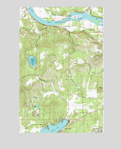
Diamond Lake, WA USGS Topographic Map
Click on map above to begin viewing in our Map Viewer.

This topographic map contains these locations and features:
Feature Name Type Latitude Longitude GNIS ID View Map
Albeni Falls CreekStreamN48.1827°W117.1274°376496View Map
Bracket CreekStreamN48.2443°W117.2347°1516916View Map
Camp CowlesLocaleN48.1305°W117.2108°1517256View Map
Carey CreekStreamN48.1641°W117.1998°2702014View Map
DalkenaPopulated PlaceN48.2449°W117.2377°1531544View Map
Deer ValleyValleyN48.1463°W117.1408°1518657View Map
DelkenaPopulated PlaceN48.2474°W117.2385°1518667View Map
Diamond LakeLakeN48.1281°W117.2011°1518754View Map
Diamond Lake Water and Sewer District Wastewater Treatment PlantLocaleN48.1282°W117.1635°2610755View Map
FurportPopulated PlaceN48.2418°W117.1760°1519855View Map
Furport HillSummitN48.2427°W117.1858°1519856View Map
Indian CreekStreamN48.2446°W117.1513°1521175View Map
Indian IslandIslandN48.2405°W117.1649°1521190View Map
Kent CreekStreamN48.2327°W117.2094°1521621View Map
Kent Meadows Lake DamDamN48.1999°W117.2260°1531973View Map
Lake Marney DamDamN48.2066°W117.2494°1531994View Map
Lake Newport State ParkParkN48.2332°W117.1538°1529426View Map
Mallard MarshLakeN48.1511°W117.2229°1522660View Map
McCloud CreekStreamN48.2318°W117.2002°1522870View Map
Mountain Meadows LakeReservoirN48.1964°W117.2306°1523441View Map
Panhandle LakeLakeN48.1590°W117.2242°1524165View Map
Pend Oreille Fire District 4 Station 41BuildingN48.2492°W117.2415°2643725View Map
Pend Oreille Fire District 6 and Rescue 6 FurportBuildingN48.2424°W117.1763°2643708View Map
Saddle MountainSummitN48.2016°W117.1252°1525334View Map
Sand ButteSummitN48.1699°W117.1305°1525407View Map
South Pend Oreille Fire and Rescue Station 33 Deer Valley RoadBuildingN48.1600°W117.1500°2643726View Map
WolfredPopulated PlaceN48.2257°W117.1372°1534118View Map
Yergens and Anselmo Dam Number OneDamN48.2049°W117.1360°1532034View Map
Yergens and Anselmo Dam Number TwoDamN48.2049°W117.1327°1532535View Map

Note: Coordinates in the location and feature list above are referenced to NAD83 datum.


Copyright (C) 2008-2024 Ryan Niemi / Sunset Dynamics ... All Rights Reserved