TopoQuest Logo
Do you find TopoQuest useful?
Help keep TopoQuest running and adding new maps/features by donating!
Bitcoin:  19c7KJd3qBynnjoSw5npx9KScwjBe4ifkT
Litecoin:  LXs6TkuXGGXo1vDsWCkWVdjQX94eUKd6ui
Home View Maps Find Maps Find Places Resources & Links


Daingerfield, Texas Topographic Map

USGS Map Title: Daingerfield, TX
USGS Map MRC: 33094A6
DRG (GeoTIFF) Download: o33094a6.tif


Neighboring USGS Topographic Map Quads:


  Cookville, TX  
33094B7
 

  Naples, TX  
33094B6
 

  Marietta, TX  
33094B5
 

  Cason, TX  
33094A7
 

  Daingerfield, TX  
33094A6
 

  Sardis, TX  
33094A5
 

  Lafayette, TX  
32094H7
 

  Lone Star, TX  
32094H6
 

  Avinger, TX  
32094H5


Map MRC Location:

N34°
W95°
N34°
W94°
H8 H7 H6 H5 H4 H3 H2 H1
G8 G7 G6 G5 G4 G3 G2 G1
F8 F7 F6 F5 F4 F3 F2 F1
E8 E7 E6 E5 E4 E3 E2 E1
D8 D7 D6 D5 D4 D3 D2 D1
C8 C7 C6 C5 C4 C3 C2 C1
B8 B7 B6 B5 B4 B3 B2 B1
A8 A7 A6 A5 A4 A3 A2 A1
N33°
W95°
N33°
W94°

Daingerfield, TX USGS 1:24K Topographic Map Preview:
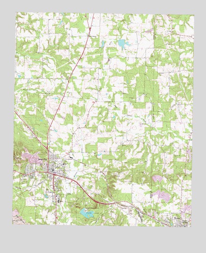
Daingerfield, TX USGS Topographic Map
Click on map above to begin viewing in our Map Viewer.

This topographic map contains these locations and features:
Feature Name Type Latitude Longitude GNIS ID View Map
Ahoads SchoolSchoolN33.0360°W94.7144°1329280View Map
Barber CemeteryCemeteryN33.0840°W94.6288°1330026View Map
Bethlehem CemeteryCemeteryN33.0907°W94.6488°1330525View Map
Bethlehem ChurchChurchN33.1148°W94.6405°1330535View Map
Bradfield ChurchChurchN33.0482°W94.6738°1331178View Map
City of DaingerfieldCivilN33.0306°W94.7251°2410284View Map
County Line ChurchChurchN33.0779°W94.6583°1333514View Map
DaingerfieldPopulated PlaceN33.0318°W94.7219°1333874View Map
Daingerfield DivisionCivilN33.0056°W94.7263°1938666View Map
Daingerfield High SchoolSchoolN33.0154°W94.7202°2007430View Map
Daingerfield Junior High SchoolSchoolN33.0354°W94.7135°2007431View Map
Daingerfield Municipal BuildingBuildingN33.0323°W94.7219°2754017View Map
Daingerfield Police DepartmentBuildingN33.0324°W94.7218°2751223View Map
Daingerfield Post OfficePost OfficeN33.0328°W94.7238°2732254View Map
Daingerfield State ParkParkN33.0087°W94.6988°1333875View Map
Daingerfield State Park DamDamN33.0068°W94.7019°1862126View Map
Daingerfield State Park LakeReservoirN33.0071°W94.6979°1862127View Map
Daingerfield State Park TrailTrailN33.0082°W94.6988°2032824View Map
Daingerfield Volunteer Fire Department / Emergency Medical ServiceBuildingN33.0315°W94.7227°2655555View Map
Day CemeteryCemeteryN33.0248°W94.6599°1334112View Map
Fellowship Baptist ChurchChurchN33.0407°W94.7258°2023095View Map
First United Methodist Church - DaingerfieldChurchN33.0326°W94.7241°2023096View Map
Florence DamDamN33.0501°W94.6252°1854993View Map
Florence LakeReservoirN33.0501°W94.6252°1854994View Map
Hall CemeteryCemeteryN33.0983°W94.6835°1337250View Map
Holly Springs CemeteryCemeteryN33.0421°W94.6377°1337961View Map
Hughes SpringsSpringN33.0085°W94.6419°1998656View Map
Irvin ParkParkN33.0176°W94.7138°2029162View Map
Jerome Wolfson DamDamN33.1085°W94.6869°1862124View Map
Jerome Wolfson LakeReservoirN33.1070°W94.6888°1862125View Map
Jones CemeteryCemeteryN33.0817°W94.6911°1338844View Map
KEGG-AM (Daingerfield)TowerN33.0265°W94.7063°1387826View Map
KWSK-FM (Daingerfield)TowerN33.0390°W94.7485°1387931View Map
Lewis CemeteryCemeteryN33.1004°W94.6530°1339846View Map
Minor LakeReservoirN33.1076°W94.6756°1862129View Map
Minor Lake DamDamN33.1101°W94.6769°1862128View Map
Morris CountyCivilN33.1135°W94.7327°1383957View Map
Morris County Constable's Office Precinct 2BuildingN33.0356°W94.7266°2751344View Map
Morris County CourthouseBuildingN33.0351°W94.7260°2030561View Map
Morris County JailBuildingN33.0356°W94.7266°2738678View Map
Morris County Sheriff's OfficeBuildingN33.0357°W94.7264°2751233View Map
Mount Zion ChurchChurchN33.1012°W94.7330°1342158View Map
Old Morris County CourthouseBuildingN33.0318°W94.7216°2031774View Map
Presbyterian Church CumberlandChurchN33.0335°W94.7260°2023097View Map
Rocky BranchPopulated PlaceN33.1115°W94.6980°1378975View Map
Rocky Branch Volunteer Fire DepartmentBuildingN33.1118°W94.6985°2655540View Map
South Elementary SchoolSchoolN33.0235°W94.7219°2007384View Map
South Side SchoolSchoolN33.0168°W94.7197°1347532View Map
Wakefield CemeteryCemeteryN33.0757°W94.6660°1349353View Map
West Elementary SchoolSchoolN33.0287°W94.7408°2007385View Map
West Side SchoolSchoolN33.0287°W94.7408°1349808View Map
Whitmore CemeteryCemeteryN33.0862°W94.7349°1350022View Map

Note: Coordinates in the location and feature list above are referenced to NAD83 datum.


Copyright (C) 2008-2024 Ryan Niemi / Sunset Dynamics ... All Rights Reserved